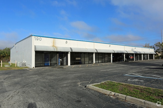
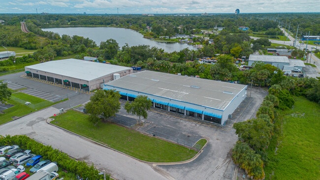
Property Record
190 Lyman Rd, Casselberry, FL 32707


Current Lease Availabilities
NEARBY LISTINGS FOR SALE OR LEASE
Property Detail
190 Lyman Rd
Orlando-Kissimmee-Sanford, FL
Casselberry Lakes Industrial Park
07-21-30-521-0000-0110
LOT 11 (LESS RD) CASSELBERRY LAKES INDUSTRIAL PARK PB 38 PG 23
Stripcommercialcenter
Seminole
X
Florida
12095C0165F
11
2025
1.38 AC
2025
Seminole County
022001
Orlando
17,161 SF
DEMOGRAPHICS near 190 Lyman Rd
1 Mile
3 Mile
5 Mile
2024 Total Population
5,322
96,299
237,498
2029 Population
5,668
100,367
247,313
Pop Growth 2024-2029
+ 6.50%
+ 4.22%
+ 4.13%
Average Age
41
42
41
2024 Total Households
2,051
40,227
99,042
HH Growth 2024-2029
+ 6.48%
+ 4.41%
+ 4.31%
Median Household Inc
$53,353
$60,508
$65,587
Avg Household Size
2.50
2.30
2.30
2024 Avg HH Vehicles
2.00
2.00
2.00
Median Home Value
$261,757
$280,603
$307,903
Median Year Built
1976
1978
1982
Nearby Places
Map Layers
Map Styles
 Street
 Aerial
- Restaurants
- Banks
- Shops
- Fitness
- Groceries
PUBLIC TRANSPORTATION
COMMUTER RAIL
Altamonte Springs (SunRail - Florida Department of Transportation)
DRIVE
WALK
Distance
Altamonte Springs (SunRail - Florida Department of Transportation)
3 min
1.5 mi
Longwood (SunRail - Florida Department of Transportation)
DRIVE
WALK
Distance
Longwood (SunRail - Florida Department of Transportation)
4 min
2.2 mi
AIRPORT
Orlando Sanford International
DRIVE
WALK
Distance
Orlando Sanford International
21 min
11.7 mi
Orlando International
DRIVE
WALK
Distance
Orlando International
31 min
18.1 mi
Freight Ports
Port Canaveral
DRIVE
WALK
Distance
Port Canaveral
77 min
60.6 mi
Nearby Properties
Address
Land Use
TOTAL SIZE
Lot Size
Zoning
Address
Land Use
TOTAL SIZE
Lot Size
Zoning
88,256 SF
39.64 AC
MOC3
Address
Land Use
TOTAL SIZE
Lot Size
Zoning
423,270 SF
3.45 AC
MOC3
Address
Land Use
TOTAL SIZE
Lot Size
Zoning
21.25 AC
GC
Address
Land Use
TOTAL SIZE
Lot Size
Zoning
629,182 SF
1.81 AC
R1A
Address
Land Use
TOTAL SIZE
Lot Size
Zoning
1,158 SF
17.22 AC
Address
Land Use
TOTAL SIZE
Lot Size
Zoning
508,923 SF
41.05 AC
C2
Address
Land Use
TOTAL SIZE
Lot Size
Zoning
Address
Land Use
TOTAL SIZE
Lot Size
Zoning
206 SF
1.43 AC
VMU
Address
Land Use
TOTAL SIZE
Lot Size
Zoning
555,833 SF
3.65 AC
DM
Address
Land Use
TOTAL SIZE
Lot Size
Zoning
400 SF
13.82 AC
R1AA
Address
Land Use
TOTAL SIZE
Lot Size
Zoning
5,256 SF
1.10 AC
PUDRES
Address
Land Use
TOTAL SIZE
Lot Size
Zoning
540 SF
7.72 AC
GC
Address
Land Use
TOTAL SIZE
Lot Size
Zoning
231,070 SF
35.59 AC
MOR2
Address
Land Use
TOTAL SIZE
Lot Size
Zoning
350,767 SF
11.12 AC
PUD
Address
Land Use
TOTAL SIZE
Lot Size
Zoning
456 SF
9.56 AC
Address
Land Use
TOTAL SIZE
Lot Size
Zoning
1,428 SF
8.56 AC
MOR3
Address
Land Use
TOTAL SIZE
Lot Size
Zoning
377,321 SF
20.58 AC
R3A
Address
Land Use
TOTAL SIZE
Lot Size
Zoning
97,888 SF
3.72 AC
IND
Address
Land Use
TOTAL SIZE
Lot Size
Zoning
6,817 SF
19.84 AC
R3
Address
Land Use
TOTAL SIZE
Lot Size
Zoning
254,371 SF
15.63 AC
R1A
Address
Land Use
TOTAL SIZE
Lot Size
Zoning
17,728 SF
14.64 AC
GC
Address
Land Use
TOTAL SIZE
Lot Size
Zoning
409,338 SF
27.27 AC
RSF-2
Address
Land Use
TOTAL SIZE
Lot Size
Zoning
279,457 SF
20.56 AC
R3
Address
Land Use
TOTAL SIZE
Lot Size
Zoning
6,466 SF
18.97 AC
MOC3
Address
Land Use
TOTAL SIZE
Lot Size
Zoning
204 SF
30 AC
R3
Address
Land Use
TOTAL SIZE
Lot Size
Zoning
259,436 SF
11.23 AC
A1
Address
Land Use
TOTAL SIZE
Lot Size
Zoning
184,227 SF
28.86 AC
MOI2
Address
Land Use
TOTAL SIZE
Lot Size
Zoning
223,895 SF
13.16 AC
R3
Address
Land Use
TOTAL SIZE
Lot Size
Zoning
147,310 SF
14.74 AC
GC
Address
Land Use
TOTAL SIZE
Lot Size
Zoning
274,020 SF
19.35 AC
R3
The World's #1 Commercial Real Estate Marketplace
Connect with us
© 2026 CoStar Group
The information above has been obtained from sources believed reliable. While we do not doubt its accuracy we have not verified it and make no guarantee, warranty or representation about it. It is your responsibility to independently confirm its accuracy and completeness. Any projections, opinions, assumptions, or estimates used are for example only and do not represent the current or future performance of the property. The value of this transaction to you depends on tax and other factors which should be evaluated by your tax, financial, and legal advisors. You and your advisors should conduct a careful, independent investigation of the property to determine to your satisfaction the suitability of the property for your needs.