Property Record
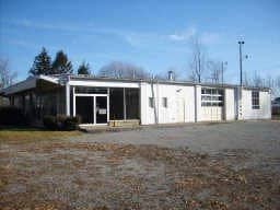
190 Main St N, Perry, NY 14530

NEARBY LISTINGS FOR SALE OR LEASE
-
-
View all Perry listings for sale on LoopNet.com
Property Detail
190 Main St N
Other Market Areas
LOT 28 OGDEN 239-113
564201-088-016-0001-017-000-0000
Wyoming
Vehiclerentalsvehiclesales
New York
2025
17.000
2024
1.20 AC
970600
New York West Area
7,042 SF
DEMOGRAPHICS near 190 Main St N
1 Mile
3 Mile
5 Mile
2024 Total Population
3,077
5,885
8,043
2029 Population
3,061
5,862
8,020
Pop Growth 2024-2029
(0.52%)
(0.39%)
(0.29%)
Average Age
39
41
42
2024 Total Households
1,325
2,351
3,075
HH Growth 2024-2029
(0.60%)
(0.04%)
+ 0.26%
Median Household Inc
$54,583
$55,802
$56,782
Avg Household Size
2.20
2.20
2.20
2024 Avg HH Vehicles
2.00
2.00
2.00
Median Home Value
$88,290
$104,753
$115,085
Median Year Built
1948
1949
1951
Nearby Places
- Restaurants
- Banks
- Shops
- Fitness
- Groceries
PUBLIC TRANSPORTATION
AIRPORT
Frederick Douglass/Greater Rochester International
DRIVE
WALK
Distance
Frederick Douglass/Greater Rochester International
58 min
40.6 mi
Nearby Properties
Address
Land Use
TOTAL SIZE
Lot Size
Zoning
Address
Land Use
TOTAL SIZE
Lot Size
Zoning
12.79 AC
05 - COMME
Address
Land Use
TOTAL SIZE
Lot Size
Zoning
660 SF
0.36 AC
04 - FARM
Address
Land Use
TOTAL SIZE
Lot Size
Zoning
Address
Land Use
TOTAL SIZE
Lot Size
Zoning
04 - FARM
Address
Land Use
TOTAL SIZE
Lot Size
Zoning
144,980 SF
8.32 AC
02
Address
Land Use
TOTAL SIZE
Lot Size
Zoning
7,040 SF
45.82 AC
02 - SINGL
Address
Land Use
TOTAL SIZE
Lot Size
Zoning
92,520 SF
6.27 AC
05 - COMME
Address
Land Use
TOTAL SIZE
Lot Size
Zoning
69,602 SF
5.16 AC
06 - INDUS
Address
Land Use
TOTAL SIZE
Lot Size
Zoning
1,962 SF
5.74 AC
05 - COMME
Address
Land Use
TOTAL SIZE
Lot Size
Zoning
Address
Land Use
TOTAL SIZE
Lot Size
Zoning
Address
Land Use
TOTAL SIZE
Lot Size
Zoning
39,600 SF
12 AC
Address
Land Use
TOTAL SIZE
Lot Size
Zoning
04 - FARM
Address
Land Use
TOTAL SIZE
Lot Size
Zoning
20,910 SF
2.63 AC
05 - COMME
Address
Land Use
TOTAL SIZE
Lot Size
Zoning
3,200 SF
2.15 AC
07 - MIXED
Address
Land Use
TOTAL SIZE
Lot Size
Zoning
2,795 SF
1.95 AC
05 - COMME
Address
Land Use
TOTAL SIZE
Lot Size
Zoning
34,217 SF
20.04 AC
02 - SINGL
Address
Land Use
TOTAL SIZE
Lot Size
Zoning
04 - FARM
Address
Land Use
TOTAL SIZE
Lot Size
Zoning
Address
Land Use
TOTAL SIZE
Lot Size
Zoning
160,499 SF
23.70 AC
06 - INDUS
Address
Land Use
TOTAL SIZE
Lot Size
Zoning
1.45 AC
02 - SINGL
Address
Land Use
TOTAL SIZE
Lot Size
Zoning
05 - COMME
Address
Land Use
TOTAL SIZE
Lot Size
Zoning
22,274 SF
5 AC
07 - MIXED
Address
Land Use
TOTAL SIZE
Lot Size
Zoning
142.97 AC
04 - FARM
Address
Land Use
TOTAL SIZE
Lot Size
Zoning
Address
Land Use
TOTAL SIZE
Lot Size
Zoning
2,540 SF
9.98 AC
02 - SINGL
Address
Land Use
TOTAL SIZE
Lot Size
Zoning
161.86 AC
04 - FARM
Address
Land Use
TOTAL SIZE
Lot Size
Zoning
1.74 AC
05 - COMME
Address
Land Use
TOTAL SIZE
Lot Size
Zoning
169.01 AC
04 - FARM
Address
Land Use
TOTAL SIZE
Lot Size
Zoning
6,924 SF
3.24 AC
05 - COMME
The World's #1 Commercial Real Estate Marketplace
Connect with us
© 2025 CoStar Group
The information above has been obtained from sources believed reliable. While we do not doubt its accuracy we have not verified it and make no guarantee, warranty or representation about it. It is your responsibility to independently confirm its accuracy and completeness. Any projections, opinions, assumptions, or estimates used are for example only and do not represent the current or future performance of the property. The value of this transaction to you depends on tax and other factors which should be evaluated by your tax, financial, and legal advisors. You and your advisors should conduct a careful, independent investigation of the property to determine to your satisfaction the suitability of the property for your needs.