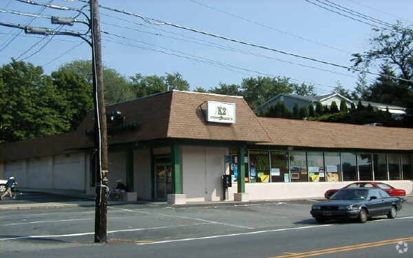
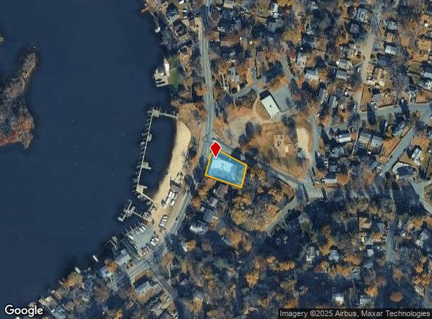
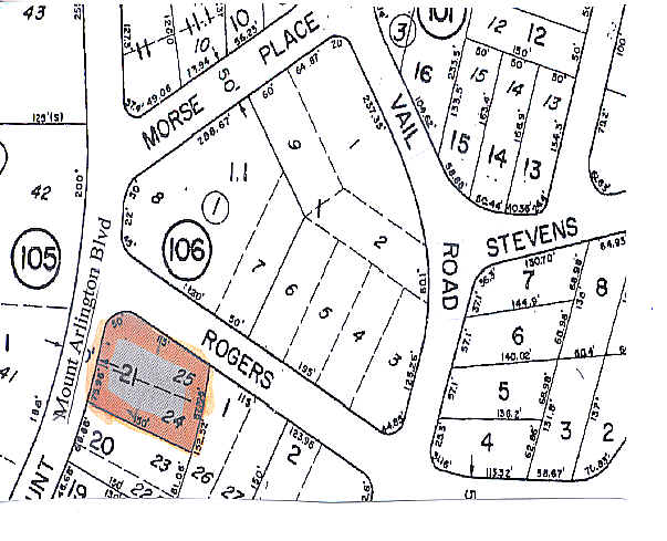
Property Record
190 Mount Arlington Blvd, Landing, NJ 07850
NEARBY LISTINGS FOR SALE OR LEASE
Property Detail
190 Mount Arlington Blvd
Newark, NJ-PA
Shore Hills/Lk Hopatcong Sec 0
36-11301-0000-00016
Morris
Supermarket
New Jersey
2024
16
2025
0.33 AC
045402
Western Morris
9,800 SF
Northern New Jersey
DEMOGRAPHICS near 190 Mount Arlington Blvd
1 Mile
3 Mile
5 Mile
2024 Total Population
7,182
39,252
90,977
2029 Population
7,245
39,554
91,447
Pop Growth 2024-2029
+ 0.88%
+ 0.77%
+ 0.52%
Average Age
44
43
42
2024 Total Households
2,939
15,686
35,235
HH Growth 2024-2029
+ 0.99%
+ 0.83%
+ 0.52%
Median Household Inc
$101,674
$95,166
$102,113
Avg Household Size
2.40
2.40
2.50
2024 Avg HH Vehicles
2.00
2.00
2.00
Median Home Value
$331,330
$320,471
$355,082
Median Year Built
1974
1968
1970
Nearby Places
Map Layers
Map Styles
 Street
 Aerial
- Restaurants
- Banks
- Shops
- Fitness
- Groceries
PUBLIC TRANSPORTATION
COMMUTER RAIL
Lake Hopatcong (Montclair-Boonton Line - NJ Transit Commuter Rail (NJ Transit), Morris & Essex Morristown Line - NJ Transit Commuter Rail (NJ Transit))
DRIVE
WALK
Distance
Lake Hopatcong (Montclair-Boonton Line - NJ Transit Commuter Rail (NJ Transit), Morris & Essex Morristown Line - NJ Transit Commuter Rail (NJ Transit))
2 min
16 min
0.8 mi
Mount Arlington (Montclair-Boonton Line - NJ Transit Commuter Rail (NJ Transit), Morris & Essex Morristown Line - NJ Transit Commuter Rail (NJ Transit))
DRIVE
WALK
Distance
Mount Arlington (Montclair-Boonton Line - NJ Transit Commuter Rail (NJ Transit), Morris & Essex Morristown Line - NJ Transit Commuter Rail (NJ Transit))
6 min
3.6 mi
AIRPORT
Newark Liberty International
DRIVE
WALK
Distance
Newark Liberty International
47 min
38.1 mi
Freight Ports
Maher Terminal
DRIVE
WALK
Distance
Maher Terminal
50 min
38.6 mi
Nearby Properties
Address
Land Use
TOTAL SIZE
Lot Size
Zoning
Address
Land Use
TOTAL SIZE
Lot Size
Zoning
Address
Land Use
TOTAL SIZE
Lot Size
Zoning
25.63 AC
B-3
Address
Land Use
TOTAL SIZE
Lot Size
Zoning
56.90 AC
Address
Land Use
TOTAL SIZE
Lot Size
Zoning
23.74 AC
B-3
Address
Land Use
TOTAL SIZE
Lot Size
Zoning
280,960 SF
46.25 AC
R-4
Address
Land Use
TOTAL SIZE
Lot Size
Zoning
44.67 AC
R2
Address
Land Use
TOTAL SIZE
Lot Size
Zoning
72.81 AC
LIOR
Address
Land Use
TOTAL SIZE
Lot Size
Zoning
8.19 AC
B-3
Address
Land Use
TOTAL SIZE
Lot Size
Zoning
440.89 AC
POLI
Address
Land Use
TOTAL SIZE
Lot Size
Zoning
48.48 AC
MLR
Address
Land Use
TOTAL SIZE
Lot Size
Zoning
126,875 SF
7.02 AC
Address
Land Use
TOTAL SIZE
Lot Size
Zoning
55.26 AC
PUD
Address
Land Use
TOTAL SIZE
Lot Size
Zoning
79,962 SF
27.80 AC
GU
Address
Land Use
TOTAL SIZE
Lot Size
Zoning
20.85 AC
I-3
Address
Land Use
TOTAL SIZE
Lot Size
Zoning
8.43 AC
B-3
Address
Land Use
TOTAL SIZE
Lot Size
Zoning
68,844 SF
5 AC
PUD
Address
Land Use
TOTAL SIZE
Lot Size
Zoning
133,934 SF
21.46 AC
PUD
Address
Land Use
TOTAL SIZE
Lot Size
Zoning
27.96 AC
R2
Address
Land Use
TOTAL SIZE
Lot Size
Zoning
65,128 SF
1.69 AC
B-2
Address
Land Use
TOTAL SIZE
Lot Size
Zoning
3.90 AC
RG-5
Address
Land Use
TOTAL SIZE
Lot Size
Zoning
1.95 AC
PO/R
Address
Land Use
TOTAL SIZE
Lot Size
Zoning
10.76 AC
RG-5
Address
Land Use
TOTAL SIZE
Lot Size
Zoning
5.70 AC
RG-5
Address
Land Use
TOTAL SIZE
Lot Size
Zoning
43,525 SF
11 AC
RA30
Address
Land Use
TOTAL SIZE
Lot Size
Zoning
26.53 AC
R-5
Address
Land Use
TOTAL SIZE
Lot Size
Zoning
98,528 SF
10.05 AC
PUD
Address
Land Use
TOTAL SIZE
Lot Size
Zoning
43,869 SF
5.19 AC
B-2
Address
Land Use
TOTAL SIZE
Lot Size
Zoning
14.93 AC
R2
Address
Land Use
TOTAL SIZE
Lot Size
Zoning
87,970 SF
6.56 AC
PUD
Address
Land Use
TOTAL SIZE
Lot Size
Zoning
40,710 SF
3.88 AC
R-2
The World's #1 Commercial Real Estate Marketplace
Connect with us
© 2025 CoStar Group
The information above has been obtained from sources believed reliable. While we do not doubt its accuracy we have not verified it and make no guarantee, warranty or representation about it. It is your responsibility to independently confirm its accuracy and completeness. Any projections, opinions, assumptions, or estimates used are for example only and do not represent the current or future performance of the property. The value of this transaction to you depends on tax and other factors which should be evaluated by your tax, financial, and legal advisors. You and your advisors should conduct a careful, independent investigation of the property to determine to your satisfaction the suitability of the property for your needs.