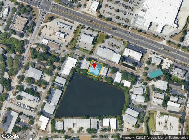
Property Record
190 Scarlet Blvd, Oldsmar, FL 34677

NEARBY LISTINGS FOR SALE OR LEASE
Property Detail
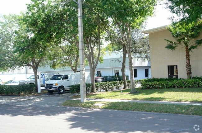
190 Scarlet Blvd
Tampa-St. Petersburg-Clearwater, FL
Oldsmar Revised Map
23-28-16-63936-068-0150
OLDSMAR REVISED MAP BLK 68, LOT 15 & PT OF LOT 14 & PT OF VAC BEDFORD ST DESC FROM MOST NLY COR OF 5 TH S69DE 130FT FOR POB TH S69DE 130FT TH S21DW 150FT TH N69DW 130FT TH N21DE 150FT TO POB (MAP N-23-28-16)
Warehouse
Pinellas
AE
Florida
12103C0091H
15,14
2024
0.46 AC
2025
North Pinellas
027320
Tampa/St Petersburg
8,948 SF
DEMOGRAPHICS near 190 Scarlet Blvd
1 Mile
3 Mile
5 Mile
2024 Total Population
7,736
49,249
159,239
2029 Population
7,641
49,278
161,966
Pop Growth 2024-2029
(1.23%)
+ 0.06%
+ 1.71%
Average Age
40
45
46
2024 Total Households
2,942
21,420
70,214
HH Growth 2024-2029
(1.50%)
(0.13%)
+ 1.43%
Median Household Inc
$81,250
$79,809
$75,248
Avg Household Size
2.60
2.20
2.20
2024 Avg HH Vehicles
2.00
2.00
2.00
Median Home Value
$330,000
$347,256
$333,596
Median Year Built
1986
1985
1986
Nearby Places
Map Layers
Map Styles
 Street
 Aerial
- Restaurants
- Banks
- Shops
- Fitness
- Groceries
PUBLIC TRANSPORTATION
AIRPORT
Tampa International
DRIVE
WALK
Distance
Tampa International
23 min
12.6 mi
St Pete-Clearwater International
DRIVE
WALK
Distance
St Pete-Clearwater International
29 min
15.2 mi
Freight Ports
Port of Tampa Bay
DRIVE
WALK
Distance
Port of Tampa Bay
37 min
21.1 mi
Nearby Properties
Address
Land Use
TOTAL SIZE
Lot Size
Zoning
Address
Land Use
TOTAL SIZE
Lot Size
Zoning
661,982 SF
19.26 AC
Address
Land Use
TOTAL SIZE
Lot Size
Zoning
462,206 SF
30.26 AC
RPD5
Address
Land Use
TOTAL SIZE
Lot Size
Zoning
358,185 SF
41.27 AC
PD
Address
Land Use
TOTAL SIZE
Lot Size
Zoning
473,742 SF
20.84 AC
Address
Land Use
TOTAL SIZE
Lot Size
Zoning
356,262 SF
15.48 AC
Address
Land Use
TOTAL SIZE
Lot Size
Zoning
417,535 SF
42.47 AC
Address
Land Use
TOTAL SIZE
Lot Size
Zoning
305,687 SF
31.48 AC
PD
Address
Land Use
TOTAL SIZE
Lot Size
Zoning
326,008 SF
53.12 AC
Address
Land Use
TOTAL SIZE
Lot Size
Zoning
302,915 SF
55.33 AC
RPD75
Address
Land Use
TOTAL SIZE
Lot Size
Zoning
236,972 SF
19.07 AC
Address
Land Use
TOTAL SIZE
Lot Size
Zoning
286,650 SF
23.36 AC
RPD5
Address
Land Use
TOTAL SIZE
Lot Size
Zoning
427,299 SF
80.27 AC
PD
Address
Land Use
TOTAL SIZE
Lot Size
Zoning
311,117 SF
16.96 AC
Address
Land Use
TOTAL SIZE
Lot Size
Zoning
241,867 SF
19.54 AC
Address
Land Use
TOTAL SIZE
Lot Size
Zoning
233,620 SF
14.13 AC
RPD5
Address
Land Use
TOTAL SIZE
Lot Size
Zoning
304,142 SF
12.19 AC
RPD5
Address
Land Use
TOTAL SIZE
Lot Size
Zoning
258,403 SF
10.62 AC
RPD5
Address
Land Use
TOTAL SIZE
Lot Size
Zoning
160,827 SF
20.22 AC
AE
Address
Land Use
TOTAL SIZE
Lot Size
Zoning
294,022 SF
15.75 AC
RPD5
Address
Land Use
TOTAL SIZE
Lot Size
Zoning
177,360 SF
9.28 AC
Address
Land Use
TOTAL SIZE
Lot Size
Zoning
188,940 SF
24.78 AC
PD
Address
Land Use
TOTAL SIZE
Lot Size
Zoning
145,000 SF
1.26 AC
Address
Land Use
TOTAL SIZE
Lot Size
Zoning
126,644 SF
19.09 AC
Address
Land Use
TOTAL SIZE
Lot Size
Zoning
220,103 SF
28.40 AC
Address
Land Use
TOTAL SIZE
Lot Size
Zoning
575,565 SF
335.60 AC
PD
Address
Land Use
TOTAL SIZE
Lot Size
Zoning
14,334 SF
117.55 AC
Address
Land Use
TOTAL SIZE
Lot Size
Zoning
198,800 SF
10.76 AC
Address
Land Use
TOTAL SIZE
Lot Size
Zoning
130,000 SF
11.27 AC
Address
Land Use
TOTAL SIZE
Lot Size
Zoning
115,788 SF
14.84 AC
C2
Address
Land Use
TOTAL SIZE
Lot Size
Zoning
102,074 SF
18.39 AC
The World's #1 Commercial Real Estate Marketplace
Connect with us
© 2025 CoStar Group
The information above has been obtained from sources believed reliable. While we do not doubt its accuracy we have not verified it and make no guarantee, warranty or representation about it. It is your responsibility to independently confirm its accuracy and completeness. Any projections, opinions, assumptions, or estimates used are for example only and do not represent the current or future performance of the property. The value of this transaction to you depends on tax and other factors which should be evaluated by your tax, financial, and legal advisors. You and your advisors should conduct a careful, independent investigation of the property to determine to your satisfaction the suitability of the property for your needs.