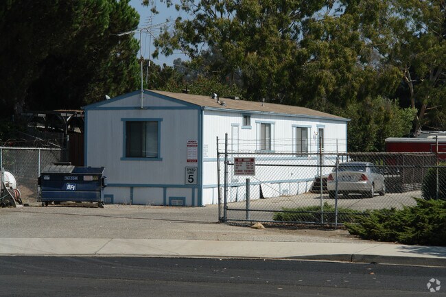
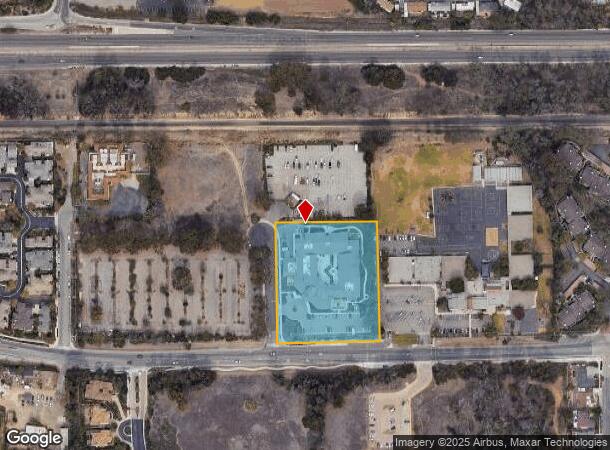
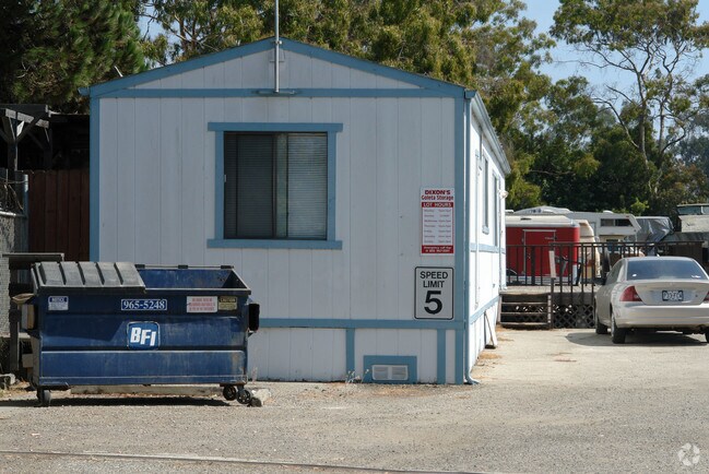
Property Record
190 Viajero Dr, Goleta, CA 93117
NEARBY LISTINGS FOR SALE OR LEASE
Property Detail
190 Viajero Dr
Santa Maria-Santa Barbara, CA
Parcel Map No 11 140
079-210-057
PM 11,140 BK 6/53 PARCEL B
Hospitalprivate
Santa Barbara
X
California
06083C1342H
b
2024
2.95 AC
2025
Santa Barbara Airport
002932
Santa Barbara/Sta Maria/Goleta
DEMOGRAPHICS near 190 Viajero Dr
1 Mile
3 Mile
5 Mile
2024 Total Population
10,659
37,775
53,966
2029 Population
10,559
37,508
53,522
Pop Growth 2024-2029
(0.94%)
(0.71%)
(0.82%)
Average Age
39
31
35
2024 Total Households
3,831
12,088
18,104
HH Growth 2024-2029
(0.97%)
(0.79%)
(0.89%)
Median Household Inc
$105,308
$71,249
$82,208
Avg Household Size
2.70
2.70
2.70
2024 Avg HH Vehicles
2.00
2.00
2.00
Median Home Value
$796,100
$811,441
$844,486
Median Year Built
1973
1977
1974
Nearby Places
Map Layers
Map Styles
 Street
 Aerial
- Restaurants
- Banks
- Shops
- Fitness
- Groceries
PUBLIC TRANSPORTATION
COMMUTER RAIL
Goleta Amtrak (Pacific Surfliner - Amtrak)
DRIVE
WALK
Distance
Goleta Amtrak (Pacific Surfliner - Amtrak)
8 min
3.8 mi
AIRPORT
Santa Barbara Municipal
DRIVE
WALK
Distance
Santa Barbara Municipal
20 min
5.2 mi
Freight Ports
The Port of Hueneme
DRIVE
WALK
Distance
The Port of Hueneme
69 min
53.0 mi
Nearby Properties
Address
Land Use
TOTAL SIZE
Lot Size
Zoning
Address
Land Use
TOTAL SIZE
Lot Size
Zoning
30.03 AC
Address
Land Use
TOTAL SIZE
Lot Size
Zoning
2.50 AC
SRH20
Address
Land Use
TOTAL SIZE
Lot Size
Zoning
1.90 AC
Address
Land Use
TOTAL SIZE
Lot Size
Zoning
13.08 AC
Address
Land Use
TOTAL SIZE
Lot Size
Zoning
39.17 AC
Address
Land Use
TOTAL SIZE
Lot Size
Zoning
8.82 AC
Address
Land Use
TOTAL SIZE
Lot Size
Zoning
4.25 AC
Address
Land Use
TOTAL SIZE
Lot Size
Zoning
2.42 AC
SRH20
Address
Land Use
TOTAL SIZE
Lot Size
Zoning
2.18 AC
Address
Land Use
TOTAL SIZE
Lot Size
Zoning
102,570 SF
14.03 AC
Address
Land Use
TOTAL SIZE
Lot Size
Zoning
3.05 AC
Address
Land Use
TOTAL SIZE
Lot Size
Zoning
37,584 SF
2 AC
SRH20
Address
Land Use
TOTAL SIZE
Lot Size
Zoning
85,052 SF
2.97 AC
SRH20
Address
Land Use
TOTAL SIZE
Lot Size
Zoning
7.18 AC
Address
Land Use
TOTAL SIZE
Lot Size
Zoning
0.87 AC
SRH20
Address
Land Use
TOTAL SIZE
Lot Size
Zoning
129,096 SF
11.56 AC
Address
Land Use
TOTAL SIZE
Lot Size
Zoning
13.74 AC
Address
Land Use
TOTAL SIZE
Lot Size
Zoning
0.38 AC
C2
Address
Land Use
TOTAL SIZE
Lot Size
Zoning
10.19 AC
Address
Land Use
TOTAL SIZE
Lot Size
Zoning
5.34 AC
Address
Land Use
TOTAL SIZE
Lot Size
Zoning
18.65 AC
Address
Land Use
TOTAL SIZE
Lot Size
Zoning
8.33 AC
Address
Land Use
TOTAL SIZE
Lot Size
Zoning
6.66 AC
Address
Land Use
TOTAL SIZE
Lot Size
Zoning
9.85 AC
Address
Land Use
TOTAL SIZE
Lot Size
Zoning
285,000 SF
4.91 AC
Address
Land Use
TOTAL SIZE
Lot Size
Zoning
1.60 AC
SRH20
Address
Land Use
TOTAL SIZE
Lot Size
Zoning
1.97 AC
SRH20
Address
Land Use
TOTAL SIZE
Lot Size
Zoning
0.36 AC
C2
Address
Land Use
TOTAL SIZE
Lot Size
Zoning
1.30 AC
SRH20
Address
Land Use
TOTAL SIZE
Lot Size
Zoning
70,700 SF
13.23 AC
The World's #1 Commercial Real Estate Marketplace
Connect with us
© 2026 CoStar Group
The information above has been obtained from sources believed reliable. While we do not doubt its accuracy we have not verified it and make no guarantee, warranty or representation about it. It is your responsibility to independently confirm its accuracy and completeness. Any projections, opinions, assumptions, or estimates used are for example only and do not represent the current or future performance of the property. The value of this transaction to you depends on tax and other factors which should be evaluated by your tax, financial, and legal advisors. You and your advisors should conduct a careful, independent investigation of the property to determine to your satisfaction the suitability of the property for your needs.