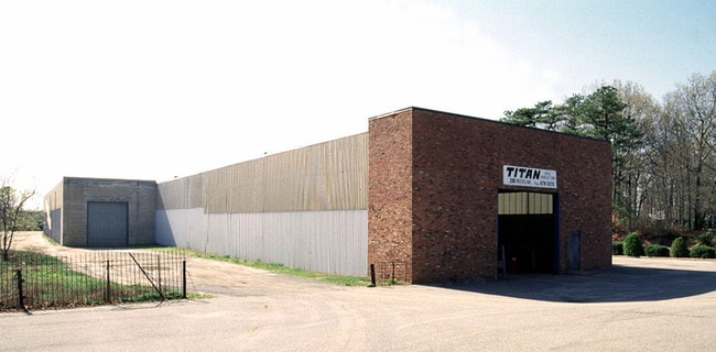
Property Record
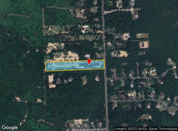
190 Weeks Ave, Manorville, NY 11949
NEARBY LISTINGS FOR SALE OR LEASE
Property Detail
190 Weeks Ave
Nassau County-Suffolk County, NY
Wampmissic
0200-558-00-01-00-019-000
WAMPMISSIC 619 46 EXC E 5X181.5
Warehouse
Suffolk
X
New York
36103C0730H
19
2024
4.98 AC
2024
Eastern Suffolk
159414
Long Island (New York)
DEMOGRAPHICS near 190 Weeks Ave
1 Mile
3 Mile
5 Mile
2024 Total Population
916
30,556
78,027
2029 Population
914
30,313
77,256
Pop Growth 2024-2029
(0.22%)
(0.80%)
(0.99%)
Average Age
39
40
40
2024 Total Households
283
10,390
26,028
HH Growth 2024-2029
(0.35%)
(0.79%)
(1.03%)
Median Household Inc
$121,428
$106,658
$103,920
Avg Household Size
2.90
2.80
2.90
2024 Avg HH Vehicles
3.00
2.00
2.00
Median Home Value
$458,585
$385,095
$400,927
Median Year Built
1985
1982
1981
Nearby Places
- Restaurants
- Banks
- Shops
- Fitness
- Groceries
PUBLIC TRANSPORTATION
COMMUTER RAIL
Mastic-Shirley Station (Montauk Branch - Long Island Rail Road)
DRIVE
WALK
Distance
Mastic-Shirley Station (Montauk Branch - Long Island Rail Road)
11 min
4.7 mi
Yaphank Station (Greenport Branch - Long Island Rail Road)
DRIVE
WALK
Distance
Yaphank Station (Greenport Branch - Long Island Rail Road)
14 min
6.6 mi
AIRPORT
Long Island MacArthur
DRIVE
WALK
Distance
Long Island MacArthur
31 min
17.1 mi
Freight Ports
Port of New Haven
DRIVE
WALK
Distance
Port of New Haven
144 min
54.6 mi
Nearby Properties
Address
Land Use
TOTAL SIZE
Lot Size
Zoning
Address
Land Use
TOTAL SIZE
Lot Size
Zoning
1,180.32 AC
Address
Land Use
TOTAL SIZE
Lot Size
Zoning
1.68 AC
Address
Land Use
TOTAL SIZE
Lot Size
Zoning
7.31 AC
LI200
Address
Land Use
TOTAL SIZE
Lot Size
Zoning
6.82 AC
LI200
Address
Land Use
TOTAL SIZE
Lot Size
Zoning
1.70 AC
RRD
Address
Land Use
TOTAL SIZE
Lot Size
Zoning
Address
Land Use
TOTAL SIZE
Lot Size
Zoning
95.60 AC
09
Address
Land Use
TOTAL SIZE
Lot Size
Zoning
17.62 AC
Address
Land Use
TOTAL SIZE
Lot Size
Zoning
109.78 AC
Address
Land Use
TOTAL SIZE
Lot Size
Zoning
Address
Land Use
TOTAL SIZE
Lot Size
Zoning
28.82 AC
Address
Land Use
TOTAL SIZE
Lot Size
Zoning
Address
Land Use
TOTAL SIZE
Lot Size
Zoning
Address
Land Use
TOTAL SIZE
Lot Size
Zoning
Address
Land Use
TOTAL SIZE
Lot Size
Zoning
48.60 AC
Address
Land Use
TOTAL SIZE
Lot Size
Zoning
0.18 AC
R20
Address
Land Use
TOTAL SIZE
Lot Size
Zoning
30.60 AC
Address
Land Use
TOTAL SIZE
Lot Size
Zoning
2.70 AC
Address
Land Use
TOTAL SIZE
Lot Size
Zoning
3,253 SF
6.80 AC
04
Address
Land Use
TOTAL SIZE
Lot Size
Zoning
39.18 AC
Address
Land Use
TOTAL SIZE
Lot Size
Zoning
0.50 AC
Address
Land Use
TOTAL SIZE
Lot Size
Zoning
Address
Land Use
TOTAL SIZE
Lot Size
Zoning
Address
Land Use
TOTAL SIZE
Lot Size
Zoning
13.63 AC
Address
Land Use
TOTAL SIZE
Lot Size
Zoning
0.62 AC
BUS1
Address
Land Use
TOTAL SIZE
Lot Size
Zoning
22 AC
Address
Land Use
TOTAL SIZE
Lot Size
Zoning
20.30 AC
Address
Land Use
TOTAL SIZE
Lot Size
Zoning
93 AC
Address
Land Use
TOTAL SIZE
Lot Size
Zoning
13.90 AC
Address
Land Use
TOTAL SIZE
Lot Size
Zoning
11.68 AC
The World's #1 Commercial Real Estate Marketplace
Connect with us
© 2025 CoStar Group
The information above has been obtained from sources believed reliable. While we do not doubt its accuracy we have not verified it and make no guarantee, warranty or representation about it. It is your responsibility to independently confirm its accuracy and completeness. Any projections, opinions, assumptions, or estimates used are for example only and do not represent the current or future performance of the property. The value of this transaction to you depends on tax and other factors which should be evaluated by your tax, financial, and legal advisors. You and your advisors should conduct a careful, independent investigation of the property to determine to your satisfaction the suitability of the property for your needs.