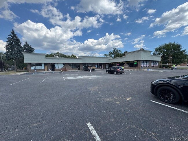
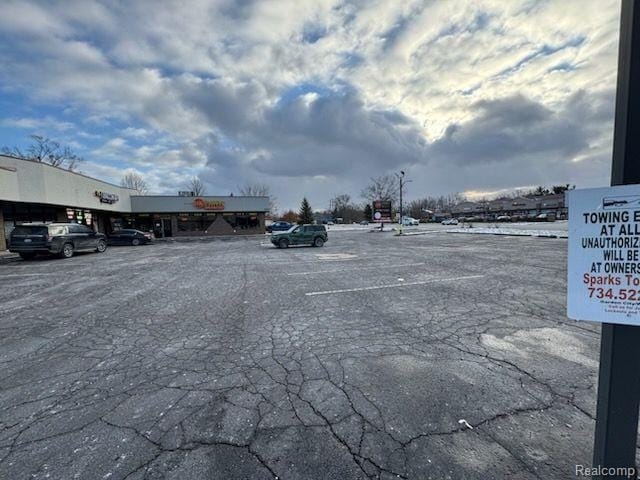
Property Record
1900 N Wayne Rd, Westland, MI 48185

Current Lease Availabilities
NEARBY LISTINGS FOR SALE OR LEASE
Property Detail
1900 N Wayne Rd
Detroit-Warren-Dearborn, MI
Ford Wayne
56-042-02-0431-300
16B 431 TO 434 453 TO 456 LOTS 431 TO 434 INCL ALSO LOTS 453 TO 456 INCL ALSO ADJ VAC ALLEY 20FT WIDE PARKWAY PLAZA FORD WAYNE SUB NO 1 T2S R9E L57 P7 WCR
Stripcommercialcenter
Wayne
X
Michigan
26163C0210E
0431
2025
0.97 AC
2025
Southern I-275 Corridor
567900
Detroit
11,000 SF
DEMOGRAPHICS near 1900 N Wayne Rd
1 Mile
3 Mile
5 Mile
2024 Total Population
12,461
105,603
247,843
2029 Population
11,946
101,423
238,093
Pop Growth 2024-2029
(4.13%)
(3.96%)
(3.93%)
Average Age
43
41
41
2024 Total Households
6,321
46,096
102,449
HH Growth 2024-2029
(4.18%)
(3.99%)
(3.98%)
Median Household Inc
$44,409
$62,064
$67,352
Avg Household Size
1.90
2.20
2.40
2024 Avg HH Vehicles
1.00
2.00
2.00
Median Home Value
$157,537
$166,204
$184,888
Median Year Built
1972
1966
1966
Nearby Places
Map Layers
Map Styles
 Street
 Aerial
- Restaurants
- Banks
- Shops
- Fitness
- Groceries
PUBLIC TRANSPORTATION
AIRPORT
Detroit Metro Wayne County
DRIVE
WALK
Distance
Detroit Metro Wayne County
21 min
12.0 mi
Windsor International
DRIVE
WALK
Distance
Windsor International
53 min
33.6 mi
Freight Ports
Port of Toledo
DRIVE
WALK
Distance
Port of Toledo
72 min
58.4 mi
Nearby Properties
Address
Land Use
TOTAL SIZE
Lot Size
Zoning
Address
Land Use
TOTAL SIZE
Lot Size
Zoning
741,173 SF
63.81 AC
Address
Land Use
TOTAL SIZE
Lot Size
Zoning
352,514 SF
26.40 AC
Address
Land Use
TOTAL SIZE
Lot Size
Zoning
480,910 SF
26.32 AC
Address
Land Use
TOTAL SIZE
Lot Size
Zoning
395,148 SF
9.67 AC
Address
Land Use
TOTAL SIZE
Lot Size
Zoning
169,489 SF
14.51 AC
R-6
Address
Land Use
TOTAL SIZE
Lot Size
Zoning
249,795 SF
21.17 AC
Address
Land Use
TOTAL SIZE
Lot Size
Zoning
176,396 SF
11.76 AC
Address
Land Use
TOTAL SIZE
Lot Size
Zoning
188,958 SF
7.71 AC
Address
Land Use
TOTAL SIZE
Lot Size
Zoning
286,188 SF
40.21 AC
Address
Land Use
TOTAL SIZE
Lot Size
Zoning
285,136 SF
15.28 AC
Address
Land Use
TOTAL SIZE
Lot Size
Zoning
16.03 AC
MR
Address
Land Use
TOTAL SIZE
Lot Size
Zoning
206,130 SF
14.12 AC
Address
Land Use
TOTAL SIZE
Lot Size
Zoning
66,670 SF
11.20 AC
C-3
Address
Land Use
TOTAL SIZE
Lot Size
Zoning
243,371 SF
16.04 AC
Address
Land Use
TOTAL SIZE
Lot Size
Zoning
269,649 SF
18.27 AC
LI-1
Address
Land Use
TOTAL SIZE
Lot Size
Zoning
199,952 SF
13.06 AC
Address
Land Use
TOTAL SIZE
Lot Size
Zoning
76,430 SF
13.61 AC
C-3
Address
Land Use
TOTAL SIZE
Lot Size
Zoning
177,268 SF
17.11 AC
Address
Land Use
TOTAL SIZE
Lot Size
Zoning
5.80 AC
MR
Address
Land Use
TOTAL SIZE
Lot Size
Zoning
197,774 SF
11.72 AC
Address
Land Use
TOTAL SIZE
Lot Size
Zoning
204,978 SF
10.28 AC
LI-1
Address
Land Use
TOTAL SIZE
Lot Size
Zoning
232,858 SF
39.67 AC
Address
Land Use
TOTAL SIZE
Lot Size
Zoning
11.38 AC
MR
Address
Land Use
TOTAL SIZE
Lot Size
Zoning
170,275 SF
16.53 AC
Address
Land Use
TOTAL SIZE
Lot Size
Zoning
238,980 SF
18.89 AC
Address
Land Use
TOTAL SIZE
Lot Size
Zoning
41.45 AC
C-3
Address
Land Use
TOTAL SIZE
Lot Size
Zoning
11.93 AC
MR
Address
Land Use
TOTAL SIZE
Lot Size
Zoning
137,400 SF
11.27 AC
Address
Land Use
TOTAL SIZE
Lot Size
Zoning
146,160 SF
8.78 AC
Address
Land Use
TOTAL SIZE
Lot Size
Zoning
165,144 SF
20.33 AC
LI-1
The World's #1 Commercial Real Estate Marketplace
Connect with us
© 2026 CoStar Group
The information above has been obtained from sources believed reliable. While we do not doubt its accuracy we have not verified it and make no guarantee, warranty or representation about it. It is your responsibility to independently confirm its accuracy and completeness. Any projections, opinions, assumptions, or estimates used are for example only and do not represent the current or future performance of the property. The value of this transaction to you depends on tax and other factors which should be evaluated by your tax, financial, and legal advisors. You and your advisors should conduct a careful, independent investigation of the property to determine to your satisfaction the suitability of the property for your needs.