Property Record
1900 Bessemer Rd, Petersburg, VA 23805


NEARBY LISTINGS FOR SALE OR LEASE
-
-
View all Petersburg listings for sale on LoopNet.com
Property Detail
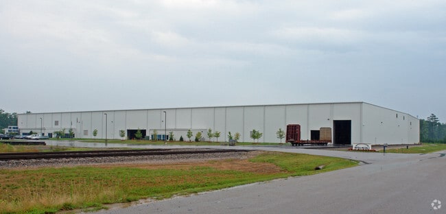
1900 Bessemer Rd
096-01-0805
Petersburg Industrial Park
Manufacturinglight
PARCEL 25.27 ACRES
X
Petersburg
51149C0145C
Virginia
2023
25.06 AC
2025
TriCities
811100
Richmond VA
149,228 SF
Richmond, VA
DEMOGRAPHICS near 1900 Bessemer Rd
1 Mile
3 Mile
5 Mile
2024 Total Population
446
23,464
58,410
2029 Population
436
23,257
58,939
Pop Growth 2024-2029
(2.24%)
(0.88%)
+ 0.91%
Average Age
46
42
40
2024 Total Households
193
10,372
23,931
HH Growth 2024-2029
(2.07%)
(0.88%)
+ 0.68%
Median Household Inc
$50,658
$46,395
$50,710
Avg Household Size
2.10
2.20
2.20
2024 Avg HH Vehicles
2.00
2.00
2.00
Median Home Value
$214,286
$141,113
$163,417
Median Year Built
1976
1969
1970
Nearby Places
Map Layers
Map Styles
 Street
 Aerial
- Restaurants
- Banks
- Shops
- Fitness
- Groceries
PUBLIC TRANSPORTATION
COMMUTER RAIL
Petersburg Amtrak Station (Carolinian - Amtrak, Northeast Regional - Amtrak, Palmetto - Amtrak, Silver Meteor - Amtrak, Silver Star - Amtrak)
DRIVE
WALK
Distance
Petersburg Amtrak Station (Carolinian - Amtrak, Northeast Regional - Amtrak, Palmetto - Amtrak, Silver Meteor - Amtrak, Silver Star - Amtrak)
13 min
6.2 mi
AIRPORT
Richmond International
DRIVE
WALK
Distance
Richmond International
46 min
33.2 mi
Freight Ports
Virginia Port Authority - Richmond
DRIVE
WALK
Distance
Virginia Port Authority - Richmond
36 min
24.3 mi
Nearby Properties
Address
Land Use
TOTAL SIZE
Lot Size
Zoning
Address
Land Use
TOTAL SIZE
Lot Size
Zoning
703.07 AC
PMD
Address
Land Use
TOTAL SIZE
Lot Size
Zoning
24.02 AC
B-2C
Address
Land Use
TOTAL SIZE
Lot Size
Zoning
67,456 SF
512.10 AC
A2
Address
Land Use
TOTAL SIZE
Lot Size
Zoning
1,232 SF
571 AC
R1
Address
Land Use
TOTAL SIZE
Lot Size
Zoning
220.52 AC
R1
Address
Land Use
TOTAL SIZE
Lot Size
Zoning
359,504 SF
32.59 AC
R-4
Address
Land Use
TOTAL SIZE
Lot Size
Zoning
17.09 AC
PUD
Address
Land Use
TOTAL SIZE
Lot Size
Zoning
11.57 AC
PUD
Address
Land Use
TOTAL SIZE
Lot Size
Zoning
14.57 AC
R-4
Address
Land Use
TOTAL SIZE
Lot Size
Zoning
185,483 SF
20.98 AC
R-4
Address
Land Use
TOTAL SIZE
Lot Size
Zoning
65,214 SF
8.46 AC
R-4
Address
Land Use
TOTAL SIZE
Lot Size
Zoning
26.67 AC
R-4
Address
Land Use
TOTAL SIZE
Lot Size
Zoning
42,561 SF
6.91 AC
B-2C
Address
Land Use
TOTAL SIZE
Lot Size
Zoning
151,980 SF
23.12 AC
PUD
Address
Land Use
TOTAL SIZE
Lot Size
Zoning
8.72 AC
PUD
Address
Land Use
TOTAL SIZE
Lot Size
Zoning
182,760 SF
10.50 AC
R-4
Address
Land Use
TOTAL SIZE
Lot Size
Zoning
1.09 AC
PUD
Address
Land Use
TOTAL SIZE
Lot Size
Zoning
102,424 SF
14.71 AC
PUD
Address
Land Use
TOTAL SIZE
Lot Size
Zoning
84,064 SF
15.54 AC
PUD
Address
Land Use
TOTAL SIZE
Lot Size
Zoning
33,360 SF
0.45 AC
B-2C
Address
Land Use
TOTAL SIZE
Lot Size
Zoning
101,722 SF
33.23 AC
M-2
Address
Land Use
TOTAL SIZE
Lot Size
Zoning
141,182 SF
7.62 AC
R-4
Address
Land Use
TOTAL SIZE
Lot Size
Zoning
36,758 SF
20.17 AC
R-1
Address
Land Use
TOTAL SIZE
Lot Size
Zoning
180,000 SF
41.92 AC
M-1
Address
Land Use
TOTAL SIZE
Lot Size
Zoning
44,311 SF
9.05 AC
R-1
Address
Land Use
TOTAL SIZE
Lot Size
Zoning
56,091 SF
3.93 AC
R-2
Address
Land Use
TOTAL SIZE
Lot Size
Zoning
294.87 AC
A2
Address
Land Use
TOTAL SIZE
Lot Size
Zoning
0.41 AC
M-1
Address
Land Use
TOTAL SIZE
Lot Size
Zoning
8 AC
PUD
The World's #1 Commercial Real Estate Marketplace
Connect with us
© 2026 CoStar Group
The information above has been obtained from sources believed reliable. While we do not doubt its accuracy we have not verified it and make no guarantee, warranty or representation about it. It is your responsibility to independently confirm its accuracy and completeness. Any projections, opinions, assumptions, or estimates used are for example only and do not represent the current or future performance of the property. The value of this transaction to you depends on tax and other factors which should be evaluated by your tax, financial, and legal advisors. You and your advisors should conduct a careful, independent investigation of the property to determine to your satisfaction the suitability of the property for your needs.