Property Record
1900 Capitol Ave, Sacramento, CA 95811

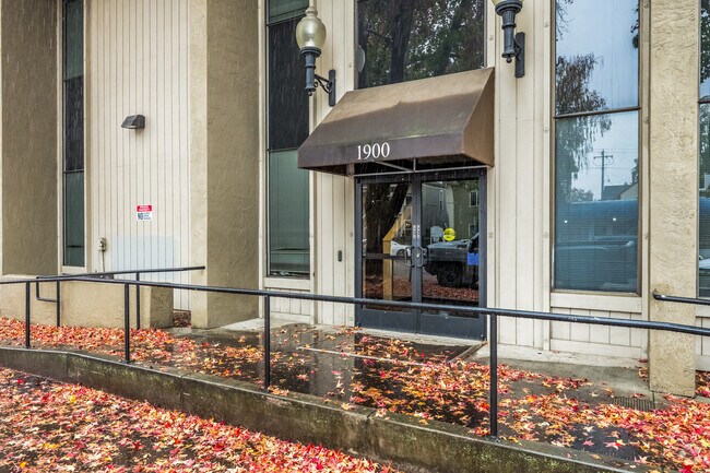

Property Detail
1900 Capitol Ave
Sacramento-Roseville-Folsom, CA
LOT 1&2 BLK M&N 19&20 CITY OF SACRAMENTO
007-0144-020
SACRAMENTO
Officebuilding
California
C-2-SPD
1,2
2024
0.59 AC
2025
Midtown
001201
Sacramento
40,500 SF
NEARBY LISTINGS FOR SALE OR LEASE
DEMOGRAPHICS near 1900 Capitol Ave
1 mile
3 mile
5 mile
2025 Total Population
32,510
161,042
406,254
2030 Population
33,534
165,014
414,179
Pop Growth 2025-2030
+ 3.15%
+ 2.47%
+ 1.95%
Average Age
38
40
38
2025 Total Households
18,864
70,547
159,797
HH Growth 2025-2030
+ 3.32%
+ 2.76%
+ 2.13%
Median Household Inc
$77,994
$86,615
$78,599
Avg Household Size
1.60
2.10
2.40
2025 Avg HH Vehicles
1.00
2.00
2.00
Median Home Value
$774,955
$678,431
$526,489
Median Year Built
1962
1958
1968
Nearby Places
Map Layers
Map Styles
 Street
 Aerial
Layers
 Traffic
 Biking
Places
Listings with unknown addresses are not visible on the map
- Restaurants
- Banks
- Shops
- Fitness
- Groceries
PUBLIC TRANSPORTATION
TRANSIT/SUBWAY
16th Street (Blue Line - Sacramento Regional Transit District Light Rail (The RT), Gold Line - Sacramento Regional Transit District Light Rail (The RT))
Drive
Walk
Distance
16th Street (Blue Line - Sacramento Regional Transit District Light Rail (The RT), Gold Line - Sacramento Regional Transit District Light Rail (The RT))
2 min
11 min
0.6 mi
23rd Street (Gold Line - Sacramento Regional Transit District Light Rail (The RT))
Drive
Walk
Distance
23rd Street (Gold Line - Sacramento Regional Transit District Light Rail (The RT))
2 min
14 min
0.7 mi
Archives Plaza (Blue Line - Sacramento Regional Transit District Light Rail (The RT), Gold Line - Sacramento Regional Transit District Light Rail (The RT))
Drive
Walk
Distance
Archives Plaza (Blue Line - Sacramento Regional Transit District Light Rail (The RT), Gold Line - Sacramento Regional Transit District Light Rail (The RT))
2 min
15 min
0.8 mi
13th Street (Blue Line - Sacramento Regional Transit District Light Rail (The RT), Gold Line - Sacramento Regional Transit District Light Rail (The RT))
Drive
Walk
Distance
13th Street (Blue Line - Sacramento Regional Transit District Light Rail (The RT), Gold Line - Sacramento Regional Transit District Light Rail (The RT))
2 min
15 min
0.8 mi
12th & I (Blue Line - Sacramento Regional Transit District Light Rail (The RT))
Drive
Walk
Distance
12th & I (Blue Line - Sacramento Regional Transit District Light Rail (The RT))
3 min
18 min
0.9 mi
COMMUTER RAIL
Drive
Walk
Distance
5 min
2.0 mi
AIRPORT
Sacramento International
Drive
Walk
Distance
Sacramento International
19 min
12.7 mi
Freight Ports
Port of Stockton
Drive
Walk
Distance
Port of Stockton
56 min
47.4 mi
Nearby Properties
Address
Land Use
TOTAL SIZE
Lot Size
Zoning
Address
Land Use
TOTAL SIZE
Lot Size
Zoning
1,095,507 SF
1.39 AC
H-SPD C-2-
Address
Land Use
TOTAL SIZE
Lot Size
Zoning
5.64 AC
C-3-SPD
Address
Land Use
TOTAL SIZE
Lot Size
Zoning
10.28 AC
H
Address
Land Use
TOTAL SIZE
Lot Size
Zoning
299,943 SF
4.95 AC
H
Address
Land Use
TOTAL SIZE
Lot Size
Zoning
487,483 SF
1.12 AC
C-3-SPD
Address
Land Use
TOTAL SIZE
Lot Size
Zoning
1.33 AC
R-1
Address
Land Use
TOTAL SIZE
Lot Size
Zoning
756,831 SF
1.39 AC
C-2-SPD
Address
Land Use
TOTAL SIZE
Lot Size
Zoning
399,626 SF
2.41 AC
C-3-SPD
Address
Land Use
TOTAL SIZE
Lot Size
Zoning
1.15 AC
R-1
Address
Land Use
TOTAL SIZE
Lot Size
Zoning
366,730 SF
0.89 AC
C-3-SPD
Address
Land Use
TOTAL SIZE
Lot Size
Zoning
200,616 SF
2.54 AC
C-2-SPD
Address
Land Use
TOTAL SIZE
Lot Size
Zoning
594,942 SF
2.39 AC
C-3-SPD
Address
Land Use
TOTAL SIZE
Lot Size
Zoning
676,447 SF
1.43 AC
C-3-SPD
Address
Land Use
TOTAL SIZE
Lot Size
Zoning
193,521 SF
0.60 AC
C-3-SPD
Address
Land Use
TOTAL SIZE
Lot Size
Zoning
339,329 SF
6.40 AC
R-5-PUD-SP
Address
Land Use
TOTAL SIZE
Lot Size
Zoning
213,557 SF
2.33 AC
C-3-SPD
Address
Land Use
TOTAL SIZE
Lot Size
Zoning
0.65 AC
C-4-SPD
Address
Land Use
TOTAL SIZE
Lot Size
Zoning
467,970 SF
4.59 AC
W-F
Address
Land Use
TOTAL SIZE
Lot Size
Zoning
410,420 SF
0.95 AC
C-3-SPD
Address
Land Use
TOTAL SIZE
Lot Size
Zoning
320,072 SF
2.65 AC
C-2
Address
Land Use
TOTAL SIZE
Lot Size
Zoning
R-4-PUD C-
Address
Land Use
TOTAL SIZE
Lot Size
Zoning
0.13 AC
WF
Address
Land Use
TOTAL SIZE
Lot Size
Zoning
26,712 SF
1.90 AC
R-5-PUD-SP
Address
Land Use
TOTAL SIZE
Lot Size
Zoning
26,712 SF
1.85 AC
R-5-PUD-SP
Address
Land Use
TOTAL SIZE
Lot Size
Zoning
2.88 AC
C-3-SPD
Address
Land Use
TOTAL SIZE
Lot Size
Zoning
508,916 SF
0.71 AC
C-3-SPD
Address
Land Use
TOTAL SIZE
Lot Size
Zoning
303,254 SF
10.63 AC
OB-PUD
Address
Land Use
TOTAL SIZE
Lot Size
Zoning
246,417 SF
1.19 AC
C-3-SPD
Address
Land Use
TOTAL SIZE
Lot Size
Zoning
405,074 SF
2.39 AC
C-3-SPD
Address
Land Use
TOTAL SIZE
Lot Size
Zoning
119,055 SF
1.18 AC
C-2-SPD
The World's #1 Commercial Real Estate Marketplace
Connect with us
© 2026 CoStar Group
The information above has been obtained from sources believed reliable. While we do not doubt its accuracy we have not verified it and make no guarantee, warranty or representation about it. It is your responsibility to independently confirm its accuracy and completeness. Any projections, opinions, assumptions, or estimates used are for example only and do not represent the current or future performance of the property. The value of this transaction to you depends on tax and other factors which should be evaluated by your tax, financial, and legal advisors. You and your advisors should conduct a careful, independent investigation of the property to determine to your satisfaction the suitability of the property for your needs.