Property Record
1900 Cardinal Ln, Faribault, MN 55021


Save to a Folder
{{folder.Name}}
{{folder.ListingIds.length}} Properties
{{folder.ListingIds.length}} Property
Create a New Folder
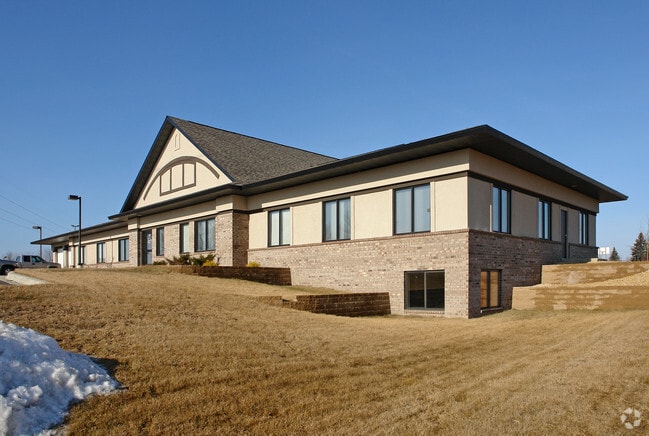
Property Detail
1900 Cardinal Ln
18.24.2.76.002
LOT 1 BLOCK 1 OF NORTHGATE ADD PART L1 B1 NORTHGATE ADD BEG MOST SLY COR L1 TH WLY ALG SLY LI L1 ON CUR CONC SLY 29.42FT TH
Officebuilding
Rice
B and X Area of moderate flood hazard, usually the area between the limits of the 100-year and 500-year floods.
Minnesota
2026
1
2026
0.88 AC
070901
Other Market Areas
5,375 SF
Faribault-Northfield, MN
NEARBY LISTINGS FOR SALE OR LEASE
DEMOGRAPHICS near 1900 Cardinal Ln
1 mile
3 mile
5 mile
2025 Total Population
2,310
18,364
28,041
2030 Population
2,364
18,755
28,657
Pop Growth 2025-2030
+ 2.34%
+ 2.13%
+ 2.20%
Average Age
40
39
40
2025 Total Households
877
7,013
10,034
HH Growth 2025-2030
+ 2.51%
+ 2.40%
+ 2.45%
Median Household Inc
$68,538
$60,781
$61,662
Avg Household Size
2.50
2.50
2.50
2025 Avg HH Vehicles
2.00
2.00
2.00
Median Home Value
$260,714
$229,907
$255,353
Median Year Built
1994
1972
1974
Nearby Places
Map Layers
Map Styles
 Street
 Aerial
Layers
 Traffic
 Biking
Places
Listings with unknown addresses are not visible on the map
- Restaurants
- Banks
- Shops
- Fitness
- Groceries
SALE & LEASE HISTORY
LISTING DATE
SALE/LEASE

Jun 27, 2018
For Lease
Aug 14, 2018
For Sale
Nearby Properties
Address
Land Use
TOTAL SIZE
Lot Size
Zoning
Address
Land Use
TOTAL SIZE
Lot Size
Zoning
334,226 SF
44.17 AC
Address
Land Use
TOTAL SIZE
Lot Size
Zoning
130,872 SF
11.59 AC
Address
Land Use
TOTAL SIZE
Lot Size
Zoning
612,036 SF
131.28 AC
Address
Land Use
TOTAL SIZE
Lot Size
Zoning
19,800 SF
40.71 AC
Address
Land Use
TOTAL SIZE
Lot Size
Zoning
59,322 SF
28 AC
Address
Land Use
TOTAL SIZE
Lot Size
Zoning
287,239 SF
26.50 AC
Address
Land Use
TOTAL SIZE
Lot Size
Zoning
320,000 SF
20.04 AC
Address
Land Use
TOTAL SIZE
Lot Size
Zoning
327,880 SF
21.89 AC
Address
Land Use
TOTAL SIZE
Lot Size
Zoning
94,471 SF
27.70 AC
Address
Land Use
TOTAL SIZE
Lot Size
Zoning
122,064 SF
2.87 AC
Address
Land Use
TOTAL SIZE
Lot Size
Zoning
14,726 SF
19.50 AC
Address
Land Use
TOTAL SIZE
Lot Size
Zoning
86,334 SF
34.30 AC
Address
Land Use
TOTAL SIZE
Lot Size
Zoning
104,074 SF
3.50 AC
Address
Land Use
TOTAL SIZE
Lot Size
Zoning
41,174 SF
2.79 AC
Address
Land Use
TOTAL SIZE
Lot Size
Zoning
78,705 SF
7.40 AC
Address
Land Use
TOTAL SIZE
Lot Size
Zoning
228,532 SF
16.73 AC
Address
Land Use
TOTAL SIZE
Lot Size
Zoning
59,468 SF
29 AC
Address
Land Use
TOTAL SIZE
Lot Size
Zoning
305,145 SF
17.32 AC
Address
Land Use
TOTAL SIZE
Lot Size
Zoning
89,616 SF
4.58 AC
Address
Land Use
TOTAL SIZE
Lot Size
Zoning
97,588 SF
1.93 AC
Address
Land Use
TOTAL SIZE
Lot Size
Zoning
92,888 SF
2.11 AC
Address
Land Use
TOTAL SIZE
Lot Size
Zoning
195,043 SF
24.73 AC
Address
Land Use
TOTAL SIZE
Lot Size
Zoning
82,651 SF
23.67 AC
Address
Land Use
TOTAL SIZE
Lot Size
Zoning
49,703 SF
4.03 AC
Address
Land Use
TOTAL SIZE
Lot Size
Zoning
26,866 SF
2.80 AC
Address
Land Use
TOTAL SIZE
Lot Size
Zoning
69,209 SF
36.05 AC
Address
Land Use
TOTAL SIZE
Lot Size
Zoning
83,289 SF
1.60 AC
Address
Land Use
TOTAL SIZE
Lot Size
Zoning
63,394 SF
3.60 AC
Address
Land Use
TOTAL SIZE
Lot Size
Zoning
254,088 SF
14.56 AC
Address
Land Use
TOTAL SIZE
Lot Size
Zoning
69,252 SF
5.10 AC
The World's #1 Commercial Real Estate Marketplace
Connect with us
© 2026 CoStar Group
The information above has been obtained from sources believed reliable. While we do not doubt its accuracy we have not verified it and make no guarantee, warranty or representation about it. It is your responsibility to independently confirm its accuracy and completeness. Any projections, opinions, assumptions, or estimates used are for example only and do not represent the current or future performance of the property. The value of this transaction to you depends on tax and other factors which should be evaluated by your tax, financial, and legal advisors. You and your advisors should conduct a careful, independent investigation of the property to determine to your satisfaction the suitability of the property for your needs.