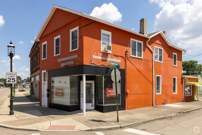
Property Record
1900 Central Ave, Middletown, OH 45044

Save to a Folder
{{folder.Name}}
{{folder.ListingIds.length}} Properties
{{folder.ListingIds.length}} Property
Create a New Folder
Property Detail
1900 Central Ave
Cincinnati, OH-KY-IN
668 NE COR CONS W/73&74
Q6532-028-000-072
BUTLER
Storebuilding
Ohio
B and X Area of moderate flood hazard, usually the area between the limits of the 100-year and 500-year floods.
668
2024
0.06 AC
2025
Butler County
014400
Cincinnati/Dayton
4,167 SF
NEARBY LISTINGS FOR SALE OR LEASE
DEMOGRAPHICS near 1900 Central Ave
1 mile
3 mile
5 mile
2025 Total Population
13,057
50,948
87,988
2030 Population
13,488
52,679
90,940
Pop Growth 2025-2030
+ 3.30%
+ 3.40%
+ 3.36%
Average Age
37
39
40
2025 Total Households
5,309
21,103
34,860
HH Growth 2025-2030
+ 3.43%
+ 3.44%
+ 3.41%
Median Household Inc
$45,111
$49,793
$64,106
Avg Household Size
2.30
2.30
2.40
2025 Avg HH Vehicles
2.00
2.00
2.00
Median Home Value
$132,019
$159,642
$205,514
Median Year Built
1947
1959
1967
Nearby Places
Map Layers
Map Styles
 Street
 Aerial
Layers
 Traffic
 Biking
Places
Listings with unknown addresses are not visible on the map
- Restaurants
- Banks
- Shops
- Fitness
- Groceries
PUBLIC TRANSPORTATION
AIRPORT
James M Cox Dayton International
Drive
Walk
Distance
James M Cox Dayton International
53 min
36.9 mi
Cincinnati/Northern Kentucky International
Drive
Walk
Distance
Cincinnati/Northern Kentucky International
69 min
48.5 mi
Nearby Properties
Address
Land Use
TOTAL SIZE
Lot Size
Zoning
Address
Land Use
TOTAL SIZE
Lot Size
Zoning
7.19 AC
Address
Land Use
TOTAL SIZE
Lot Size
Zoning
16.57 AC
Address
Land Use
TOTAL SIZE
Lot Size
Zoning
Address
Land Use
TOTAL SIZE
Lot Size
Zoning
17.24 AC
ADV
Address
Land Use
TOTAL SIZE
Lot Size
Zoning
84,352 SF
0.30 AC
Address
Land Use
TOTAL SIZE
Lot Size
Zoning
86.47 AC
ADV
Address
Land Use
TOTAL SIZE
Lot Size
Zoning
54,005 SF
0.33 AC
Address
Land Use
TOTAL SIZE
Lot Size
Zoning
57,248 SF
224.87 AC
Address
Land Use
TOTAL SIZE
Lot Size
Zoning
Address
Land Use
TOTAL SIZE
Lot Size
Zoning
33,362 SF
0.73 AC
Address
Land Use
TOTAL SIZE
Lot Size
Zoning
371,743 SF
24.58 AC
ADV
Address
Land Use
TOTAL SIZE
Lot Size
Zoning
9,069 SF
115.70 AC
Address
Land Use
TOTAL SIZE
Lot Size
Zoning
118,671 SF
5.46 AC
ADV
Address
Land Use
TOTAL SIZE
Lot Size
Zoning
166 AC
ADV
Address
Land Use
TOTAL SIZE
Lot Size
Zoning
16,779 SF
2.19 AC
Address
Land Use
TOTAL SIZE
Lot Size
Zoning
14.86 AC
Address
Land Use
TOTAL SIZE
Lot Size
Zoning
Address
Land Use
TOTAL SIZE
Lot Size
Zoning
499,497 SF
20.30 AC
ADV
Address
Land Use
TOTAL SIZE
Lot Size
Zoning
19,168 SF
7.69 AC
Address
Land Use
TOTAL SIZE
Lot Size
Zoning
29.15 AC
ADV
Address
Land Use
TOTAL SIZE
Lot Size
Zoning
236,670 SF
17.78 AC
Address
Land Use
TOTAL SIZE
Lot Size
Zoning
20,160 SF
0.10 AC
Address
Land Use
TOTAL SIZE
Lot Size
Zoning
34,090 SF
2.14 AC
Address
Land Use
TOTAL SIZE
Lot Size
Zoning
50,389 SF
5.84 AC
Address
Land Use
TOTAL SIZE
Lot Size
Zoning
23,260 SF
4 AC
Address
Land Use
TOTAL SIZE
Lot Size
Zoning
60 AC
ADV
Address
Land Use
TOTAL SIZE
Lot Size
Zoning
2.92 AC
ADV
Address
Land Use
TOTAL SIZE
Lot Size
Zoning
3.14 AC
Address
Land Use
TOTAL SIZE
Lot Size
Zoning
522,237 SF
11.14 AC
ADV
Address
Land Use
TOTAL SIZE
Lot Size
Zoning
11.21 AC
ADV
The World's #1 Commercial Real Estate Marketplace
Connect with us
© 2026 CoStar Group
The information above has been obtained from sources believed reliable. While we do not doubt its accuracy we have not verified it and make no guarantee, warranty or representation about it. It is your responsibility to independently confirm its accuracy and completeness. Any projections, opinions, assumptions, or estimates used are for example only and do not represent the current or future performance of the property. The value of this transaction to you depends on tax and other factors which should be evaluated by your tax, financial, and legal advisors. You and your advisors should conduct a careful, independent investigation of the property to determine to your satisfaction the suitability of the property for your needs.