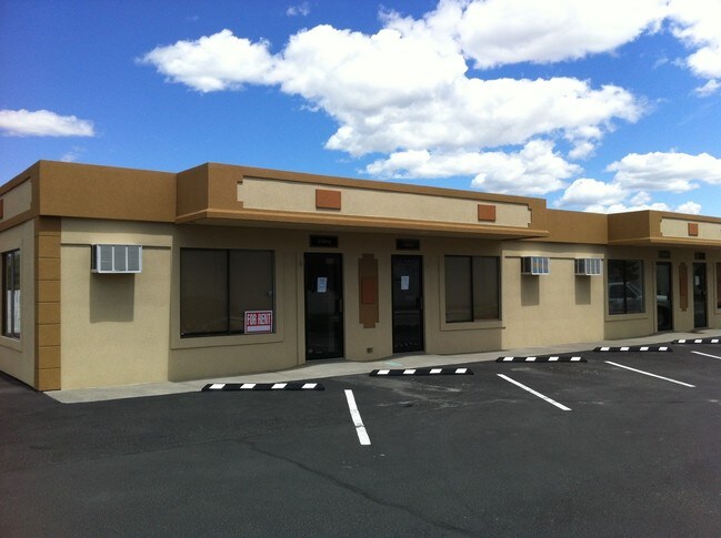
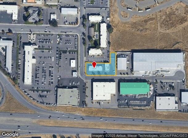
Property Record
1900 Fowler St, Richland, WA 99352
NEARBY LISTINGS FOR SALE OR LEASE
Property Detail
1900 Fowler St
Other Market Areas
Short Plat #2829
Kennewick-Richland, WA
SECTION 29 TOWNSHIP 9 RANGE 29 QUARTER SW; SHORT PLAT #2829, LOT 1, AF #2004-029454 (8/17/2004). RECORDS OF BENTON COUNTY, WASHINGTON.
129993012829001
Benton
Commercialnec
Washington
2024
1
2024
0.76 AC
010820
Yakima/Kennewick
7,500 SF
DEMOGRAPHICS near 1900 Fowler St
1 Mile
3 Mile
5 Mile
2024 Total Population
2,730
68,840
174,051
2029 Population
2,940
74,166
187,973
Pop Growth 2024-2029
+ 7.69%
+ 7.74%
+ 8.00%
Average Age
40
38
37
2024 Total Households
1,171
25,952
62,619
HH Growth 2024-2029
+ 7.86%
+ 7.73%
+ 7.99%
Median Household Inc
$78,652
$80,763
$80,185
Avg Household Size
2.20
2.60
2.70
2024 Avg HH Vehicles
2.00
2.00
2.00
Median Home Value
$248,818
$345,182
$342,113
Median Year Built
1987
1995
1994
Nearby Places
Map Layers
Map Styles
 Street
 Aerial
- Restaurants
- Banks
- Shops
- Fitness
- Groceries
PUBLIC TRANSPORTATION
COMMUTER RAIL
Pasco Amtrak Station (Empire Builder - Amtrak)
DRIVE
WALK
Distance
Pasco Amtrak Station (Empire Builder - Amtrak)
14 min
8.6 mi
AIRPORT
Tri-Cities
DRIVE
WALK
Distance
Tri-Cities
13 min
8.6 mi
Freight Ports
Port of Tacoma
DRIVE
WALK
Distance
Port of Tacoma
265 min
232.1 mi
Nearby Properties
Address
Land Use
TOTAL SIZE
Lot Size
Zoning
Address
Land Use
TOTAL SIZE
Lot Size
Zoning
478,378 SF
25.15 AC
KENNEWICK
Address
Land Use
TOTAL SIZE
Lot Size
Zoning
277,530 SF
14.99 AC
Address
Land Use
TOTAL SIZE
Lot Size
Zoning
378,471 SF
16.21 AC
RICHLAND -
Address
Land Use
TOTAL SIZE
Lot Size
Zoning
254,856 SF
10.47 AC
Address
Land Use
TOTAL SIZE
Lot Size
Zoning
232,463 SF
31.54 AC
Address
Land Use
TOTAL SIZE
Lot Size
Zoning
238,088 SF
17.06 AC
Address
Land Use
TOTAL SIZE
Lot Size
Zoning
195,749 SF
12.29 AC
35
Address
Land Use
TOTAL SIZE
Lot Size
Zoning
248,623 SF
12 AC
Address
Land Use
TOTAL SIZE
Lot Size
Zoning
168,650 SF
10.43 AC
KENNEWICK
Address
Land Use
TOTAL SIZE
Lot Size
Zoning
Address
Land Use
TOTAL SIZE
Lot Size
Zoning
179,139 SF
11.79 AC
Address
Land Use
TOTAL SIZE
Lot Size
Zoning
183,266 SF
10 AC
Address
Land Use
TOTAL SIZE
Lot Size
Zoning
206,208 SF
10.01 AC
KENNEWICK
Address
Land Use
TOTAL SIZE
Lot Size
Zoning
82,470 SF
12.38 AC
Address
Land Use
TOTAL SIZE
Lot Size
Zoning
200,734 SF
12.38 AC
Address
Land Use
TOTAL SIZE
Lot Size
Zoning
126,589 SF
4.05 AC
Address
Land Use
TOTAL SIZE
Lot Size
Zoning
74,556 SF
1.22 AC
Address
Land Use
TOTAL SIZE
Lot Size
Zoning
144,723 SF
6.88 AC
Address
Land Use
TOTAL SIZE
Lot Size
Zoning
118,412 SF
9.91 AC
KENNEWICK
Address
Land Use
TOTAL SIZE
Lot Size
Zoning
78,836 SF
13.64 AC
Address
Land Use
TOTAL SIZE
Lot Size
Zoning
127,840 SF
3.69 AC
Address
Land Use
TOTAL SIZE
Lot Size
Zoning
157,320 SF
3.80 AC
53
Address
Land Use
TOTAL SIZE
Lot Size
Zoning
116,283 SF
11.18 AC
RICHLAND -
Address
Land Use
TOTAL SIZE
Lot Size
Zoning
105,026 SF
8.63 AC
KENNEWICK
Address
Land Use
TOTAL SIZE
Lot Size
Zoning
66,035 SF
15.38 AC
Address
Land Use
TOTAL SIZE
Lot Size
Zoning
132,060 SF
6.74 AC
35
Address
Land Use
TOTAL SIZE
Lot Size
Zoning
154,818 SF
16.84 AC
KENNEWICK
Address
Land Use
TOTAL SIZE
Lot Size
Zoning
76,234 SF
7.32 AC
58
Address
Land Use
TOTAL SIZE
Lot Size
Zoning
102,155 SF
9.98 AC
Address
Land Use
TOTAL SIZE
Lot Size
Zoning
76,028 SF
1.83 AC
The World's #1 Commercial Real Estate Marketplace
Connect with us
© 2025 CoStar Group
The information above has been obtained from sources believed reliable. While we do not doubt its accuracy we have not verified it and make no guarantee, warranty or representation about it. It is your responsibility to independently confirm its accuracy and completeness. Any projections, opinions, assumptions, or estimates used are for example only and do not represent the current or future performance of the property. The value of this transaction to you depends on tax and other factors which should be evaluated by your tax, financial, and legal advisors. You and your advisors should conduct a careful, independent investigation of the property to determine to your satisfaction the suitability of the property for your needs.