Property Record
1900 Gateway Blvd, Mckinney, TX 75070
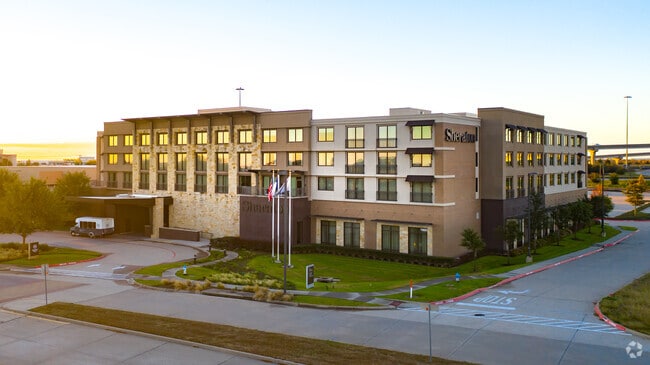

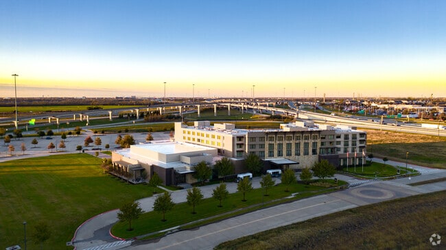
Property Detail
1900 Gateway Blvd
R-9552-000-0010-1
MCKINNEY GATEWAY CONDOMINIUM THE, UNIT 1, 79.4445 % CMN INT; HOTEL
Commercialnec
Collin
COMM/HOTEL
Texas
B and X Area of moderate flood hazard, usually the area between the limits of the 100-year and 500-year floods.
1
2025
6.53 AC
2025
McKinney
030801
Dallas/Ft Worth
160,087 SF
Dallas-Fort Worth-Arlington, TX
NEARBY LISTINGS FOR SALE OR LEASE
-
-
View all Mckinney listings for sale on LoopNet.com
DEMOGRAPHICS near 1900 Gateway Blvd
1 mile
3 mile
5 mile
2025 Total Population
11,854
93,041
245,031
2030 Population
13,493
106,217
280,153
Pop Growth 2025-2030
+ 13.83%
+ 14.16%
+ 14.33%
Average Age
39
39
38
2025 Total Households
5,349
34,141
88,171
HH Growth 2025-2030
+ 14.13%
+ 14.41%
+ 14.59%
Median Household Inc
$69,941
$110,677
$115,173
Avg Household Size
2.10
2.70
2.70
2025 Avg HH Vehicles
1.00
2.00
2.00
Median Home Value
$464,664
$525,839
$513,319
Median Year Built
2006
2004
2006
Nearby Places
Map Layers
Map Styles
 Street
 Aerial
Transit
 Traffic
 Biking
Places
Listings with unknown addresses are not visible on the map
- Restaurants
- Banks
- Shops
- Fitness
- Groceries
PUBLIC TRANSPORTATION
AIRPORT
Dallas Love Field
Drive
Walk
Distance
Dallas Love Field
41 min
31.2 mi
Dallas-Fort Worth International
Drive
Walk
Distance
Dallas-Fort Worth International
39 min
33.8 mi
Freight Ports
Port of Shreveport
Drive
Walk
Distance
Port of Shreveport
237 min
217.5 mi
Nearby Properties
Address
Land Use
TOTAL SIZE
Lot Size
Zoning
Address
Land Use
TOTAL SIZE
Lot Size
Zoning
638,539 SF
42.76 AC
Address
Land Use
TOTAL SIZE
Lot Size
Zoning
472,185 SF
63.51 AC
AO
Address
Land Use
TOTAL SIZE
Lot Size
Zoning
611,780 SF
59.06 AC
L1
Address
Land Use
TOTAL SIZE
Lot Size
Zoning
720,571 SF
68.28 AC
Address
Land Use
TOTAL SIZE
Lot Size
Zoning
162,000 SF
34 AC
L1
Address
Land Use
TOTAL SIZE
Lot Size
Zoning
495,048 SF
7.37 AC
Address
Land Use
TOTAL SIZE
Lot Size
Zoning
518,353 SF
28.51 AC
MF-M
Address
Land Use
TOTAL SIZE
Lot Size
Zoning
479,620 SF
14.02 AC
Address
Land Use
TOTAL SIZE
Lot Size
Zoning
475,847 SF
16.34 AC
RG-18
Address
Land Use
TOTAL SIZE
Lot Size
Zoning
291,577 SF
69.24 AC
APTTOWNH
Address
Land Use
TOTAL SIZE
Lot Size
Zoning
350,018 SF
7.02 AC
MF-E
Address
Land Use
TOTAL SIZE
Lot Size
Zoning
370,860 SF
25.48 AC
Address
Land Use
TOTAL SIZE
Lot Size
Zoning
260,340 SF
18.64 AC
RG-18
Address
Land Use
TOTAL SIZE
Lot Size
Zoning
379,701 SF
17.58 AC
MULTI-FAMI
Address
Land Use
TOTAL SIZE
Lot Size
Zoning
344,076 SF
15.49 AC
MULTI-FAMI
Address
Land Use
TOTAL SIZE
Lot Size
Zoning
879,029 SF
50.26 AC
ML
Address
Land Use
TOTAL SIZE
Lot Size
Zoning
349,991 SF
13.53 AC
MF-M
Address
Land Use
TOTAL SIZE
Lot Size
Zoning
727,459 SF
48.83 AC
Address
Land Use
TOTAL SIZE
Lot Size
Zoning
725,223 SF
46.60 AC
Address
Land Use
TOTAL SIZE
Lot Size
Zoning
356,096 SF
19.50 AC
MF-M
Address
Land Use
TOTAL SIZE
Lot Size
Zoning
301,764 SF
20.88 AC
MF
Address
Land Use
TOTAL SIZE
Lot Size
Zoning
337,121 SF
9.39 AC
Address
Land Use
TOTAL SIZE
Lot Size
Zoning
321,982 SF
22.83 AC
SFR
Address
Land Use
TOTAL SIZE
Lot Size
Zoning
272,853 SF
17.32 AC
PD/ML
Address
Land Use
TOTAL SIZE
Lot Size
Zoning
1,708,448 SF
85.24 AC
Address
Land Use
TOTAL SIZE
Lot Size
Zoning
281,420 SF
9.43 AC
PD/ML
Address
Land Use
TOTAL SIZE
Lot Size
Zoning
173,393 SF
9.04 AC
MF-M
Address
Land Use
TOTAL SIZE
Lot Size
Zoning
201,484 SF
48.39 AC
PD/ML
Address
Land Use
TOTAL SIZE
Lot Size
Zoning
244,257 SF
8.01 AC
AG
Address
Land Use
TOTAL SIZE
Lot Size
Zoning
204,175 SF
10.57 AC
MF-H
The World's #1 Commercial Real Estate Marketplace
Connect with us
© 2026 CoStar Group
The information above has been obtained from sources believed reliable. While we do not doubt its accuracy we have not verified it and make no guarantee, warranty or representation about it. It is your responsibility to independently confirm its accuracy and completeness. Any projections, opinions, assumptions, or estimates used are for example only and do not represent the current or future performance of the property. The value of this transaction to you depends on tax and other factors which should be evaluated by your tax, financial, and legal advisors. You and your advisors should conduct a careful, independent investigation of the property to determine to your satisfaction the suitability of the property for your needs.