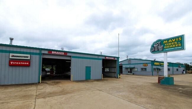
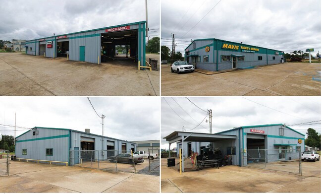
Property Record
1900 E Highway 80 St, Haughton, LA 71037

Property Detail
1900 E Highway 80 St
171561
BEGIN AT SE CORNER OF NW 1/4 OF NE 1/4 OF SECTION THENCE N 00 DEG 46 MIN 33 SEC E 850.98 FT TO PT OF BEGIN THENCE N 88 DEG 28
Loftbuilding
BOSSIER
B and X Area of moderate flood hazard, usually the area between the limits of the 100-year and 500-year floods.
Louisiana
2024
1 AC
2024
Bossier Parish
011113
Shreveport/Bossier City
5,000 SF
Shreveport-Bossier City, LA
NEARBY LISTINGS FOR SALE OR LEASE
-
-
View all Haughton listings for sale on LoopNet.com
DEMOGRAPHICS near 1900 E Highway 80 St
1 mile
3 mile
5 mile
2025 Total Population
3,624
16,997
28,709
2030 Population
3,698
17,284
29,179
Pop Growth 2025-2030
+ 2.04%
+ 1.69%
+ 1.64%
Average Age
42
39
39
2025 Total Households
1,382
6,403
10,828
HH Growth 2025-2030
+ 2.10%
+ 1.78%
+ 1.73%
Median Household Inc
$79,578
$83,765
$78,900
Avg Household Size
2.60
2.60
2.60
2025 Avg HH Vehicles
2.00
2.00
2.00
Median Home Value
$195,641
$232,159
$221,707
Median Year Built
1987
1994
1992
Nearby Places
Map Layers
Map Styles
 Street
 Aerial
Transit
 Traffic
 Biking
Places
Listings with unknown addresses are not visible on the map
- Restaurants
- Banks
- Shops
- Fitness
- Groceries
PUBLIC TRANSPORTATION
AIRPORT
Shreveport Regional
Drive
Walk
Distance
Shreveport Regional
32 min
18.3 mi
Freight Ports
Port of Shreveport
Drive
Walk
Distance
Port of Shreveport
35 min
21.8 mi
SALE & LEASE HISTORY
LISTING DATE
SALE/LEASE

Sep 25, 2024
For Sale
Nearby Properties
Address
Land Use
TOTAL SIZE
Lot Size
Zoning
Address
Land Use
TOTAL SIZE
Lot Size
Zoning
1.01 AC
Address
Land Use
TOTAL SIZE
Lot Size
Zoning
601,879 SF
269 AC
Address
Land Use
TOTAL SIZE
Lot Size
Zoning
49,550 SF
65 AC
Address
Land Use
TOTAL SIZE
Lot Size
Zoning
133,198 SF
54 AC
Address
Land Use
TOTAL SIZE
Lot Size
Zoning
70,590 SF
28 AC
Address
Land Use
TOTAL SIZE
Lot Size
Zoning
65,942 SF
10 AC
Address
Land Use
TOTAL SIZE
Lot Size
Zoning
52,264 SF
8 AC
Address
Land Use
TOTAL SIZE
Lot Size
Zoning
3,300 SF
Address
Land Use
TOTAL SIZE
Lot Size
Zoning
42,294 SF
5.86 AC
Address
Land Use
TOTAL SIZE
Lot Size
Zoning
36,591 SF
37 AC
Address
Land Use
TOTAL SIZE
Lot Size
Zoning
2.46 AC
Address
Land Use
TOTAL SIZE
Lot Size
Zoning
51,950 SF
32.79 AC
Address
Land Use
TOTAL SIZE
Lot Size
Zoning
82,358 SF
1 AC
Address
Land Use
TOTAL SIZE
Lot Size
Zoning
47,500 SF
2.97 AC
Address
Land Use
TOTAL SIZE
Lot Size
Zoning
17,051 SF
Address
Land Use
TOTAL SIZE
Lot Size
Zoning
114,000 SF
1 AC
Address
Land Use
TOTAL SIZE
Lot Size
Zoning
52,193 SF
4.33 AC
Address
Land Use
TOTAL SIZE
Lot Size
Zoning
227 SF
40 AC
Address
Land Use
TOTAL SIZE
Lot Size
Zoning
67,387 SF
67 AC
Address
Land Use
TOTAL SIZE
Lot Size
Zoning
14,760 SF
15.12 AC
Address
Land Use
TOTAL SIZE
Lot Size
Zoning
Address
Land Use
TOTAL SIZE
Lot Size
Zoning
46,592 SF
4.23 AC
Address
Land Use
TOTAL SIZE
Lot Size
Zoning
11,500 SF
4 AC
Address
Land Use
TOTAL SIZE
Lot Size
Zoning
6,279 SF
10 AC
Address
Land Use
TOTAL SIZE
Lot Size
Zoning
35,100 SF
4 AC
Address
Land Use
TOTAL SIZE
Lot Size
Zoning
49,023 SF
5 AC
Address
Land Use
TOTAL SIZE
Lot Size
Zoning
15,000 SF
8 AC
Address
Land Use
TOTAL SIZE
Lot Size
Zoning
4,234 SF
3.68 AC
Address
Land Use
TOTAL SIZE
Lot Size
Zoning
22,848 SF
3 AC
The World's #1 Commercial Real Estate Marketplace
Connect with us
© 2026 CoStar Group
The information above has been obtained from sources believed reliable. While we do not doubt its accuracy we have not verified it and make no guarantee, warranty or representation about it. It is your responsibility to independently confirm its accuracy and completeness. Any projections, opinions, assumptions, or estimates used are for example only and do not represent the current or future performance of the property. The value of this transaction to you depends on tax and other factors which should be evaluated by your tax, financial, and legal advisors. You and your advisors should conduct a careful, independent investigation of the property to determine to your satisfaction the suitability of the property for your needs.