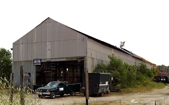
Property Record
1900 Johns Dr, Glenview, IL 60025

Property Detail
1900 Johns Dr
Chicago-Naperville-Elgin, IL-IN
COOK
04-27-202-005-0000
Illinois
Commercialnec
1
B and X Area of moderate flood hazard, usually the area between the limits of the 100-year and 500-year floods.
4.78 AC
2023
North Cook
2025
Chicago
802100
NEARBY LISTINGS FOR SALE OR LEASE
DEMOGRAPHICS near 1900 Johns Dr
1 mile
3 mile
5 mile
2025 Total Population
11,632
94,518
293,804
2030 Population
11,797
95,521
296,441
Pop Growth 2025-2030
+ 1.42%
+ 1.06%
+ 0.90%
Average Age
45
44
44
2025 Total Households
4,600
34,682
107,296
HH Growth 2025-2030
+ 1.26%
+ 0.94%
+ 0.75%
Median Household Inc
$111,573
$125,306
$113,045
Avg Household Size
2.40
2.60
2.60
2025 Avg HH Vehicles
2.00
2.00
2.00
Median Home Value
$670,239
$599,186
$482,710
Median Year Built
1997
1972
1967
Nearby Places
Map Layers
Map Styles
 Street
 Aerial
Layers
 Traffic
 Biking
Places
Listings with unknown addresses are not visible on the map
- Restaurants
- Banks
- Shops
- Fitness
- Groceries
PUBLIC TRANSPORTATION
COMMUTER RAIL
North Glenview Station (Milwaukee District North Line - Northeast Illinois Regional Commuter Railroad (Metra))
Drive
Walk
Distance
North Glenview Station (Milwaukee District North Line - Northeast Illinois Regional Commuter Railroad (Metra))
3 min
18 min
0.9 mi
Glenview Station (Milwaukee District North Line - Northeast Illinois Regional Commuter Railroad (Metra))
Drive
Walk
Distance
Glenview Station (Milwaukee District North Line - Northeast Illinois Regional Commuter Railroad (Metra))
3 min
1.2 mi
AIRPORT
Chicago O'Hare International
Drive
Walk
Distance
Chicago O'Hare International
24 min
13.4 mi
Chicago Midway International
Drive
Walk
Distance
Chicago Midway International
42 min
24.5 mi
Freight Ports
Port Milwaukee
Drive
Walk
Distance
Port Milwaukee
85 min
70.1 mi
Nearby Properties
Address
Land Use
TOTAL SIZE
Lot Size
Zoning
Address
Land Use
TOTAL SIZE
Lot Size
Zoning
Address
Land Use
TOTAL SIZE
Lot Size
Zoning
8.04 AC
Address
Land Use
TOTAL SIZE
Lot Size
Zoning
39.26 AC
Address
Land Use
TOTAL SIZE
Lot Size
Zoning
206,160 SF
9.44 AC
Address
Land Use
TOTAL SIZE
Lot Size
Zoning
76,014 SF
2.81 AC
Address
Land Use
TOTAL SIZE
Lot Size
Zoning
552,862 SF
45.76 AC
Address
Land Use
TOTAL SIZE
Lot Size
Zoning
142,300 SF
13.16 AC
Address
Land Use
TOTAL SIZE
Lot Size
Zoning
14.11 AC
Address
Land Use
TOTAL SIZE
Lot Size
Zoning
98,802 SF
1.06 AC
Address
Land Use
TOTAL SIZE
Lot Size
Zoning
172,538 SF
5.60 AC
Address
Land Use
TOTAL SIZE
Lot Size
Zoning
450,768 SF
6.97 AC
Address
Land Use
TOTAL SIZE
Lot Size
Zoning
495,857 SF
19.55 AC
Address
Land Use
TOTAL SIZE
Lot Size
Zoning
449,568 SF
22.73 AC
Address
Land Use
TOTAL SIZE
Lot Size
Zoning
284,708 SF
17.74 AC
Address
Land Use
TOTAL SIZE
Lot Size
Zoning
103,323 SF
10.65 AC
Address
Land Use
TOTAL SIZE
Lot Size
Zoning
679,109 SF
24.46 AC
Address
Land Use
TOTAL SIZE
Lot Size
Zoning
6.90 AC
Address
Land Use
TOTAL SIZE
Lot Size
Zoning
276,112 SF
10.02 AC
Address
Land Use
TOTAL SIZE
Lot Size
Zoning
8.89 AC
Address
Land Use
TOTAL SIZE
Lot Size
Zoning
73,815 SF
4.35 AC
Address
Land Use
TOTAL SIZE
Lot Size
Zoning
27.59 AC
Address
Land Use
TOTAL SIZE
Lot Size
Zoning
91,505 SF
4.86 AC
Address
Land Use
TOTAL SIZE
Lot Size
Zoning
5,769 SF
18.18 AC
Address
Land Use
TOTAL SIZE
Lot Size
Zoning
251,385 SF
17.46 AC
Address
Land Use
TOTAL SIZE
Lot Size
Zoning
87,442 SF
6.73 AC
Address
Land Use
TOTAL SIZE
Lot Size
Zoning
18.69 AC
Address
Land Use
TOTAL SIZE
Lot Size
Zoning
172,544 SF
7.22 AC
Address
Land Use
TOTAL SIZE
Lot Size
Zoning
78,819 SF
5.86 AC
Address
Land Use
TOTAL SIZE
Lot Size
Zoning
189,892 SF
Address
Land Use
TOTAL SIZE
Lot Size
Zoning
17.91 AC
The World's #1 Commercial Real Estate Marketplace
Connect with us
© 2026 CoStar Group
The information above has been obtained from sources believed reliable. While we do not doubt its accuracy we have not verified it and make no guarantee, warranty or representation about it. It is your responsibility to independently confirm its accuracy and completeness. Any projections, opinions, assumptions, or estimates used are for example only and do not represent the current or future performance of the property. The value of this transaction to you depends on tax and other factors which should be evaluated by your tax, financial, and legal advisors. You and your advisors should conduct a careful, independent investigation of the property to determine to your satisfaction the suitability of the property for your needs.