Property Record
1900 S Lowery St, Oklahoma City, OK 73129

NEARBY LISTINGS FOR SALE OR LEASE
-
-
-
-
-
-
SW 13th And Robinson - 2 Lots Near Scissortail Park
Oklahoma City, OK 73109
$210,000
0.20 AC Lots
Land
-
-
-
-
-
-
-
-
-
-
View all Oklahoma City listings for sale on LoopNet.com
Property Detail
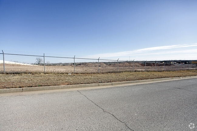
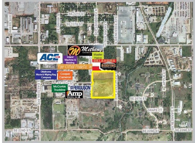
1900 S Lowery St
Oklahoma City, OK
Oklahoma Industrial Park
100091150
OKLAHOMA INDUSTRIAL PARK 002 000 LOTS 5
Warehouse
Oklahoma
AE
Oklahoma
40109C0305H
5
2023
11.18 AC
2024
South
107305
Oklahoma City
100,000 SF
DEMOGRAPHICS near 1900 S Lowery St
1 Mile
3 Mile
5 Mile
2024 Total Population
2,650
62,838
188,169
2029 Population
2,708
64,931
195,076
Pop Growth 2024-2029
+ 2.19%
+ 3.33%
+ 3.67%
Average Age
37
36
36
2024 Total Households
1,010
24,897
74,710
HH Growth 2024-2029
+ 2.38%
+ 3.45%
+ 3.69%
Median Household Inc
$38,801
$39,860
$43,603
Avg Household Size
2.50
2.40
2.40
2024 Avg HH Vehicles
2.00
2.00
2.00
Median Home Value
$69,400
$81,590
$98,998
Median Year Built
1958
1969
1965
Nearby Places
Map Layers
Map Styles
 Street
 Aerial
- Restaurants
- Banks
- Shops
- Fitness
- Groceries
PUBLIC TRANSPORTATION
COMMUTER RAIL
DRIVE
WALK
Distance
9 min
4.4 mi
AIRPORT
Will Rogers World
DRIVE
WALK
Distance
Will Rogers World
22 min
14.1 mi
SALE & LEASE HISTORY
LISTING DATE
SALE/LEASE

Sep 24, 2016
For Sale
Nearby Properties
Address
Land Use
TOTAL SIZE
Lot Size
Zoning
Address
Land Use
TOTAL SIZE
Lot Size
Zoning
52,331 SF
2.72 AC
DBD
Address
Land Use
TOTAL SIZE
Lot Size
Zoning
324,688 SF
1.36 AC
DBD
Address
Land Use
TOTAL SIZE
Lot Size
Zoning
101,216 SF
1.23 AC
Address
Land Use
TOTAL SIZE
Lot Size
Zoning
303,589 SF
7.17 AC
PUD
Address
Land Use
TOTAL SIZE
Lot Size
Zoning
382,618 SF
5.13 AC
BC
Address
Land Use
TOTAL SIZE
Lot Size
Zoning
38,866 SF
2.89 AC
DBD
Address
Land Use
TOTAL SIZE
Lot Size
Zoning
307,772 SF
1.32 AC
DBD
Address
Land Use
TOTAL SIZE
Lot Size
Zoning
281,052 SF
1.89 AC
DBD
Address
Land Use
TOTAL SIZE
Lot Size
Zoning
42,450 SF
0.32 AC
BC
Address
Land Use
TOTAL SIZE
Lot Size
Zoning
302,236 SF
2.62 AC
SPUD
Address
Land Use
TOTAL SIZE
Lot Size
Zoning
279,464 SF
1.49 AC
DBD
Address
Land Use
TOTAL SIZE
Lot Size
Zoning
188,121 SF
0.83 AC
BC
Address
Land Use
TOTAL SIZE
Lot Size
Zoning
344,045 SF
0.55 AC
DBD
Address
Land Use
TOTAL SIZE
Lot Size
Zoning
246,881 SF
1.10 AC
DBD
Address
Land Use
TOTAL SIZE
Lot Size
Zoning
502,508 SF
2.27 AC
DBD
Address
Land Use
TOTAL SIZE
Lot Size
Zoning
184,398 SF
8.09 AC
PUD
Address
Land Use
TOTAL SIZE
Lot Size
Zoning
621,489 SF
3.10 AC
DBD
Address
Land Use
TOTAL SIZE
Lot Size
Zoning
312,675 SF
25.01 AC
Address
Land Use
TOTAL SIZE
Lot Size
Zoning
150,272 SF
1.54 AC
DBD
Address
Land Use
TOTAL SIZE
Lot Size
Zoning
0.42 AC
BC
Address
Land Use
TOTAL SIZE
Lot Size
Zoning
460,398 SF
0.69 AC
DBD
Address
Land Use
TOTAL SIZE
Lot Size
Zoning
496,495 SF
2.02 AC
DBD
Address
Land Use
TOTAL SIZE
Lot Size
Zoning
104,100 SF
2.41 AC
PUD
Address
Land Use
TOTAL SIZE
Lot Size
Zoning
85,949 SF
0.50 AC
BC
Address
Land Use
TOTAL SIZE
Lot Size
Zoning
110,937 SF
0.55 AC
BC
Address
Land Use
TOTAL SIZE
Lot Size
Zoning
109,781 SF
0.91 AC
DBD
Address
Land Use
TOTAL SIZE
Lot Size
Zoning
392,100 SF
7.87 AC
I-2
Address
Land Use
TOTAL SIZE
Lot Size
Zoning
95,330 SF
25.68 AC
Address
Land Use
TOTAL SIZE
Lot Size
Zoning
296,700 SF
9.17 AC
I-2
Address
Land Use
TOTAL SIZE
Lot Size
Zoning
197,130 SF
0.64 AC
BC
The World's #1 Commercial Real Estate Marketplace
Connect with us
© 2025 CoStar Group
The information above has been obtained from sources believed reliable. While we do not doubt its accuracy we have not verified it and make no guarantee, warranty or representation about it. It is your responsibility to independently confirm its accuracy and completeness. Any projections, opinions, assumptions, or estimates used are for example only and do not represent the current or future performance of the property. The value of this transaction to you depends on tax and other factors which should be evaluated by your tax, financial, and legal advisors. You and your advisors should conduct a careful, independent investigation of the property to determine to your satisfaction the suitability of the property for your needs.