Property Record
1900 Mt Hermon Rd, Midlothian, VA 23112
NEARBY LISTINGS FOR SALE OR LEASE
-
-
View all Midlothian listings for sale on LoopNet.com
Property Detail
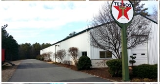
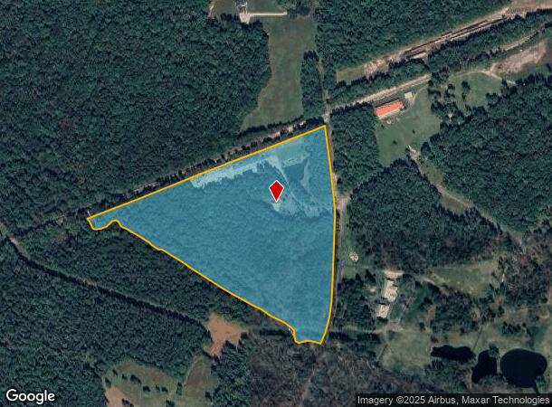
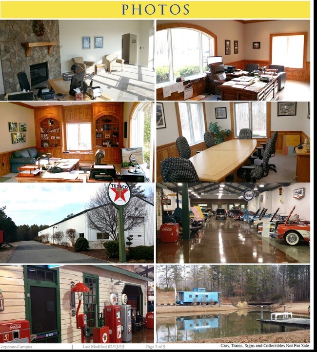
1900 Mt Hermon Rd
703-69-90-41-100-000
Western Line Of Mt Hermon Rd
Warehouse
WESTERN LINE OF MT HERMON RD
AE
Chesterfield
51145C0300C
Virginia
2025
28.31 AC
2025
Rt 288 Corridor
100938
Richmond VA
10,000 SF
Richmond, VA
DEMOGRAPHICS near 1900 Mt Hermon Rd
1 Mile
3 Mile
5 Mile
2024 Total Population
172
8,248
47,833
2029 Population
194
9,237
53,259
Pop Growth 2024-2029
+ 12.79%
+ 11.99%
+ 11.34%
Average Age
35
37
39
2024 Total Households
51
2,620
17,045
HH Growth 2024-2029
+ 11.76%
+ 11.95%
+ 11.32%
Median Household Inc
$183,928
$165,941
$129,855
Avg Household Size
3.40
3.10
2.80
2024 Avg HH Vehicles
2.00
2.00
2.00
Median Home Value
$571,428
$481,742
$432,507
Median Year Built
2011
2010
2006
Nearby Places
Map Layers
Map Styles
 Street
 Aerial
- Restaurants
- Banks
- Shops
- Fitness
- Groceries
PUBLIC TRANSPORTATION
AIRPORT
Richmond International
DRIVE
WALK
Distance
Richmond International
50 min
32.4 mi
Freight Ports
Virginia Port Authority - Richmond
DRIVE
WALK
Distance
Virginia Port Authority - Richmond
40 min
21.3 mi
Nearby Properties
Address
Land Use
TOTAL SIZE
Lot Size
Zoning
Address
Land Use
TOTAL SIZE
Lot Size
Zoning
99,934 SF
81.69 AC
A - AGRICU
Address
Land Use
TOTAL SIZE
Lot Size
Zoning
249.81 AC
RTH - RES,
Address
Land Use
TOTAL SIZE
Lot Size
Zoning
138.73 AC
RTH - RES,
Address
Land Use
TOTAL SIZE
Lot Size
Zoning
6,515 SF
2.89 AC
O2 - CORP
Address
Land Use
TOTAL SIZE
Lot Size
Zoning
102.40 AC
RTH - RES,
Address
Land Use
TOTAL SIZE
Lot Size
Zoning
1,800 SF
5.25 AC
CC
Address
Land Use
TOTAL SIZE
Lot Size
Zoning
9,408 SF
19.13 AC
A - AGRICU
Address
Land Use
TOTAL SIZE
Lot Size
Zoning
19,862 SF
6.38 AC
A - AGRICU
Address
Land Use
TOTAL SIZE
Lot Size
Zoning
123.21 AC
R12 - SING
Address
Land Use
TOTAL SIZE
Lot Size
Zoning
123.21 AC
R12 - SING
Address
Land Use
TOTAL SIZE
Lot Size
Zoning
544 SF
2.02 AC
A - AGRICU
Address
Land Use
TOTAL SIZE
Lot Size
Zoning
58.56 AC
C3 - COMMU
Address
Land Use
TOTAL SIZE
Lot Size
Zoning
15,690 SF
3.71 AC
CC
Address
Land Use
TOTAL SIZE
Lot Size
Zoning
3,870 SF
51.26 AC
RTH - RES,
Address
Land Use
TOTAL SIZE
Lot Size
Zoning
51.15 AC
C3 - COMMU
Address
Land Use
TOTAL SIZE
Lot Size
Zoning
12,992 SF
5.09 AC
I-1
Address
Land Use
TOTAL SIZE
Lot Size
Zoning
128.39 AC
R12 - SING
Address
Land Use
TOTAL SIZE
Lot Size
Zoning
19,810 SF
1.56 AC
I-1
Address
Land Use
TOTAL SIZE
Lot Size
Zoning
84.20 AC
C3 - COMMU
Address
Land Use
TOTAL SIZE
Lot Size
Zoning
12,000 SF
5.08 AC
CC
Address
Land Use
TOTAL SIZE
Lot Size
Zoning
5,928 SF
2.75 AC
CC
Address
Land Use
TOTAL SIZE
Lot Size
Zoning
33.20 AC
R12 - SING
Address
Land Use
TOTAL SIZE
Lot Size
Zoning
33.48 AC
R12 - SING
Address
Land Use
TOTAL SIZE
Lot Size
Zoning
43.14 AC
I-1
Address
Land Use
TOTAL SIZE
Lot Size
Zoning
15,620 SF
2.48 AC
CC
Address
Land Use
TOTAL SIZE
Lot Size
Zoning
9,000 SF
3.47 AC
CC
Address
Land Use
TOTAL SIZE
Lot Size
Zoning
13,743 SF
4.60 AC
A - AGRICU
Address
Land Use
TOTAL SIZE
Lot Size
Zoning
14,267 SF
2.84 AC
A - AGRICU
The World's #1 Commercial Real Estate Marketplace
Connect with us
© 2025 CoStar Group
The information above has been obtained from sources believed reliable. While we do not doubt its accuracy we have not verified it and make no guarantee, warranty or representation about it. It is your responsibility to independently confirm its accuracy and completeness. Any projections, opinions, assumptions, or estimates used are for example only and do not represent the current or future performance of the property. The value of this transaction to you depends on tax and other factors which should be evaluated by your tax, financial, and legal advisors. You and your advisors should conduct a careful, independent investigation of the property to determine to your satisfaction the suitability of the property for your needs.