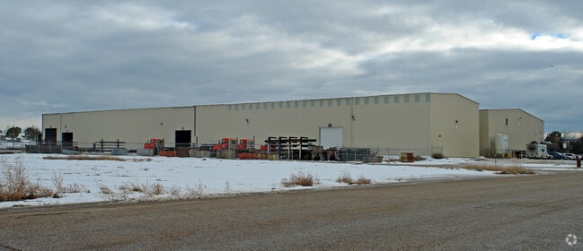
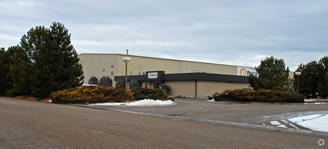
Property Record
1900 N 20Th St, Nampa, ID 83687

NEARBY LISTINGS FOR SALE OR LEASE
Property Detail
1900 N 20Th St
3119500000
14-3N-2W NW TAX 51 IN NW 1/4 SURFACE RIGHTS ONLY
Industrialgeneral
Canyon
X
Idaho
16027C0381F
9.68 AC
2024
Nampa
2025
Boise City/Nampa
020404
Boise City, ID
76,984 SF
DEMOGRAPHICS near 1900 N 20Th St
1 Mile
3 Mile
5 Mile
2024 Total Population
4,863
60,367
138,186
2029 Population
6,009
73,535
168,193
Pop Growth 2024-2029
+ 23.57%
+ 21.81%
+ 21.71%
Average Age
36
37
37
2024 Total Households
1,754
21,520
47,750
HH Growth 2024-2029
+ 23.89%
+ 22.13%
+ 22.02%
Median Household Inc
$40,179
$55,456
$65,115
Avg Household Size
2.80
2.70
2.80
2024 Avg HH Vehicles
2.00
2.00
2.00
Median Home Value
$341,385
$325,385
$349,075
Median Year Built
1997
1992
1998
Nearby Places
Map Layers
Map Styles
 Street
 Aerial
- Restaurants
- Banks
- Shops
- Fitness
- Groceries
PUBLIC TRANSPORTATION
AIRPORT
Boise Air Trml/Gowen Field
DRIVE
WALK
Distance
Boise Air Trml/Gowen Field
29 min
19.5 mi
Nearby Properties
Address
Land Use
TOTAL SIZE
Lot Size
Zoning
Address
Land Use
TOTAL SIZE
Lot Size
Zoning
61.03 AC
Address
Land Use
TOTAL SIZE
Lot Size
Zoning
52,235 SF
16.19 AC
Address
Land Use
TOTAL SIZE
Lot Size
Zoning
13.53 AC
Address
Land Use
TOTAL SIZE
Lot Size
Zoning
345,974 SF
40.28 AC
Address
Land Use
TOTAL SIZE
Lot Size
Zoning
33.22 AC
M1
Address
Land Use
TOTAL SIZE
Lot Size
Zoning
28.03 AC
M1
Address
Land Use
TOTAL SIZE
Lot Size
Zoning
239,139 SF
38.34 AC
M1
Address
Land Use
TOTAL SIZE
Lot Size
Zoning
40.26 AC
Address
Land Use
TOTAL SIZE
Lot Size
Zoning
908 SF
48.85 AC
Address
Land Use
TOTAL SIZE
Lot Size
Zoning
13.10 AC
Address
Land Use
TOTAL SIZE
Lot Size
Zoning
2,222 SF
12.28 AC
RR
Address
Land Use
TOTAL SIZE
Lot Size
Zoning
11.26 AC
Address
Land Use
TOTAL SIZE
Lot Size
Zoning
95.54 AC
Address
Land Use
TOTAL SIZE
Lot Size
Zoning
28.08 AC
Address
Land Use
TOTAL SIZE
Lot Size
Zoning
18.74 AC
Address
Land Use
TOTAL SIZE
Lot Size
Zoning
158.05 AC
M1
Address
Land Use
TOTAL SIZE
Lot Size
Zoning
11.15 AC
Address
Land Use
TOTAL SIZE
Lot Size
Zoning
1,048 SF
13.09 AC
Address
Land Use
TOTAL SIZE
Lot Size
Zoning
3,308 SF
7.06 AC
Address
Land Use
TOTAL SIZE
Lot Size
Zoning
243,353 SF
20.57 AC
Address
Land Use
TOTAL SIZE
Lot Size
Zoning
219,520 SF
26.72 AC
Address
Land Use
TOTAL SIZE
Lot Size
Zoning
149.04 AC
Address
Land Use
TOTAL SIZE
Lot Size
Zoning
1.03 AC
Address
Land Use
TOTAL SIZE
Lot Size
Zoning
244,100 SF
13.64 AC
Address
Land Use
TOTAL SIZE
Lot Size
Zoning
8.34 AC
R1
Address
Land Use
TOTAL SIZE
Lot Size
Zoning
136,249 SF
16.36 AC
Address
Land Use
TOTAL SIZE
Lot Size
Zoning
11.48 AC
Address
Land Use
TOTAL SIZE
Lot Size
Zoning
1,212 SF
14.91 AC
Address
Land Use
TOTAL SIZE
Lot Size
Zoning
11.75 AC
Address
Land Use
TOTAL SIZE
Lot Size
Zoning
2.96 AC
The World's #1 Commercial Real Estate Marketplace
Connect with us
© 2026 CoStar Group
The information above has been obtained from sources believed reliable. While we do not doubt its accuracy we have not verified it and make no guarantee, warranty or representation about it. It is your responsibility to independently confirm its accuracy and completeness. Any projections, opinions, assumptions, or estimates used are for example only and do not represent the current or future performance of the property. The value of this transaction to you depends on tax and other factors which should be evaluated by your tax, financial, and legal advisors. You and your advisors should conduct a careful, independent investigation of the property to determine to your satisfaction the suitability of the property for your needs.