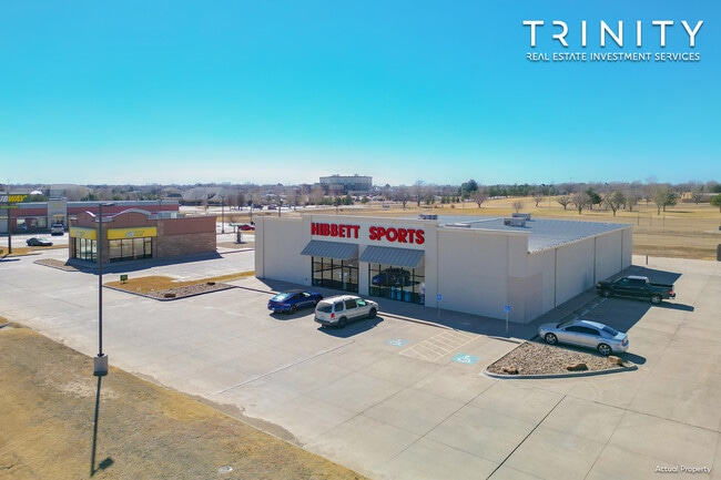
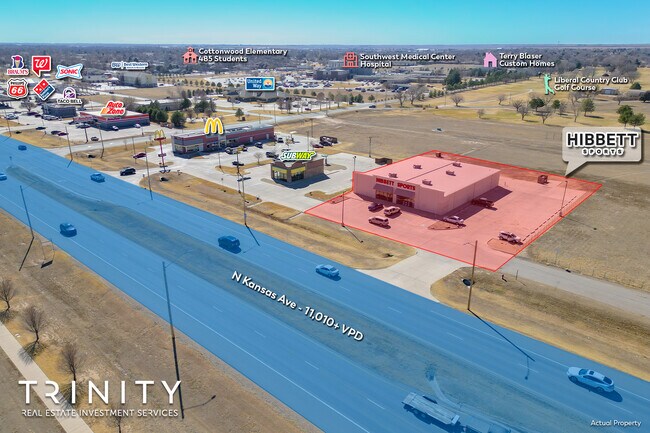
Property Record
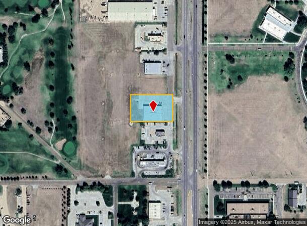
1900 N Kansas Ave, Liberal, KS 67901
NEARBY LISTINGS FOR SALE OR LEASE
-
-
View all Liberal listings for sale on LoopNet.com
Property Detail
1900 N Kansas Ave
Liberal, KS
Polo Fields Sub
149-29-0-40-01-001.24-0
POLO FIELDS SUB, BLOCK 2, E263' LT 4 & S53' OF E263' LT 5
Storebuilding
Seward
AE
Kansas
20175C0341D
4,5
2024
1.01 AC
2025
Kansas Area
965700
Other Market Areas
9,900 SF
DEMOGRAPHICS near 1900 N Kansas Ave
1 Mile
3 Mile
5 Mile
2024 Total Population
6,637
19,390
19,643
2029 Population
6,387
18,689
18,929
Pop Growth 2024-2029
(3.77%)
(3.62%)
(3.63%)
Average Age
35
34
34
2024 Total Households
2,255
6,459
6,545
HH Growth 2024-2029
(3.86%)
(3.59%)
(3.61%)
Median Household Inc
$54,768
$51,811
$51,876
Avg Household Size
2.80
2.90
2.90
2024 Avg HH Vehicles
2.00
2.00
2.00
Median Home Value
$148,556
$119,994
$120,544
Median Year Built
1977
1970
1970
Nearby Places
Map Layers
Map Styles
 Street
 Aerial
- Restaurants
- Banks
- Shops
- Fitness
- Groceries
SALE & LEASE HISTORY
LISTING DATE
SALE/LEASE

Mar 01, 2023
For Sale
Nearby Properties
Address
Land Use
TOTAL SIZE
Lot Size
Zoning
Address
Land Use
TOTAL SIZE
Lot Size
Zoning
69,614 SF
39.37 AC
RS
Address
Land Use
TOTAL SIZE
Lot Size
Zoning
69,643 SF
76.50 AC
Address
Land Use
TOTAL SIZE
Lot Size
Zoning
240,692 SF
63.30 AC
IP
Address
Land Use
TOTAL SIZE
Lot Size
Zoning
3,250 SF
64.26 AC
Address
Land Use
TOTAL SIZE
Lot Size
Zoning
69,732 SF
5.40 AC
C3
Address
Land Use
TOTAL SIZE
Lot Size
Zoning
76,875 SF
19.50 AC
Address
Land Use
TOTAL SIZE
Lot Size
Zoning
69,614 SF
39.37 AC
Address
Land Use
TOTAL SIZE
Lot Size
Zoning
109,680 SF
36 AC
Address
Land Use
TOTAL SIZE
Lot Size
Zoning
50,708 SF
2.50 AC
C2
Address
Land Use
TOTAL SIZE
Lot Size
Zoning
41,125 SF
39.37 AC
R1
Address
Land Use
TOTAL SIZE
Lot Size
Zoning
41,125 SF
39.37 AC
MH
Address
Land Use
TOTAL SIZE
Lot Size
Zoning
26,920 SF
0.96 AC
C3
Address
Land Use
TOTAL SIZE
Lot Size
Zoning
70.70 AC
Address
Land Use
TOTAL SIZE
Lot Size
Zoning
84,001 SF
11 AC
R1
Address
Land Use
TOTAL SIZE
Lot Size
Zoning
54,565 SF
4.80 AC
Address
Land Use
TOTAL SIZE
Lot Size
Zoning
35,223 SF
3.80 AC
IP
Address
Land Use
TOTAL SIZE
Lot Size
Zoning
36,604 SF
10.90 AC
R5
Address
Land Use
TOTAL SIZE
Lot Size
Zoning
30,264 SF
0.48 AC
C3
Address
Land Use
TOTAL SIZE
Lot Size
Zoning
12,971 SF
1.50 AC
RS
Address
Land Use
TOTAL SIZE
Lot Size
Zoning
31,770 SF
7.70 AC
R1
Address
Land Use
TOTAL SIZE
Lot Size
Zoning
28,105 SF
4.70 AC
R1
Address
Land Use
TOTAL SIZE
Lot Size
Zoning
5,500 SF
18.50 AC
RS
Address
Land Use
TOTAL SIZE
Lot Size
Zoning
11,179 SF
0.39 AC
C3
Address
Land Use
TOTAL SIZE
Lot Size
Zoning
8,525 SF
2.07 AC
Address
Land Use
TOTAL SIZE
Lot Size
Zoning
179,958 SF
25.20 AC
Address
Land Use
TOTAL SIZE
Lot Size
Zoning
3,222 SF
82.42 AC
Address
Land Use
TOTAL SIZE
Lot Size
Zoning
26,630 SF
2.01 AC
R1
Address
Land Use
TOTAL SIZE
Lot Size
Zoning
331,878 SF
204.10 AC
Address
Land Use
TOTAL SIZE
Lot Size
Zoning
629.60 AC
Address
Land Use
TOTAL SIZE
Lot Size
Zoning
26,637 SF
3.28 AC
R1
The World's #1 Commercial Real Estate Marketplace
Connect with us
© 2025 CoStar Group
The information above has been obtained from sources believed reliable. While we do not doubt its accuracy we have not verified it and make no guarantee, warranty or representation about it. It is your responsibility to independently confirm its accuracy and completeness. Any projections, opinions, assumptions, or estimates used are for example only and do not represent the current or future performance of the property. The value of this transaction to you depends on tax and other factors which should be evaluated by your tax, financial, and legal advisors. You and your advisors should conduct a careful, independent investigation of the property to determine to your satisfaction the suitability of the property for your needs.