Property Record
1900 Ne 36Th St, Oklahoma City, OK 73111
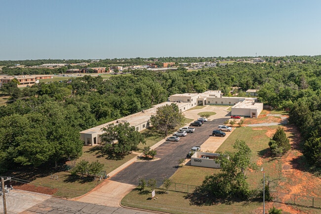

This Property Is For Sale
NEARBY LISTINGS FOR SALE OR LEASE
Property Detail
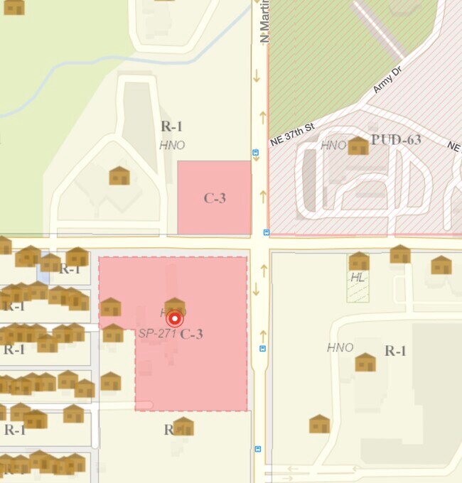
1900 Ne 36Th St
070572000
Vairy Addition
Hospitalprivate
VAIRY ADDITION 000 000 BLK 1 & E455FT OF BLK 4 SUBJ TO ESMTS OF RECORD
AE
Oklahoma
40109C0190H
Oklahoma
2023
7.17 AC
2024
North
100400
Oklahoma City
24,521 SF
Oklahoma City, OK
DEMOGRAPHICS near 1900 Ne 36Th St
1 Mile
3 Mile
5 Mile
2024 Total Population
5,572
40,434
123,310
2029 Population
5,839
42,090
127,467
Pop Growth 2024-2029
+ 4.79%
+ 4.10%
+ 3.37%
Average Age
40
39
38
2024 Total Households
2,287
19,033
55,060
HH Growth 2024-2029
+ 4.90%
+ 4.17%
+ 3.46%
Median Household Inc
$33,379
$41,248
$48,867
Avg Household Size
2.20
2.00
2.10
2024 Avg HH Vehicles
1.00
2.00
2.00
Median Home Value
$67,585
$174,945
$167,541
Median Year Built
1955
1954
1958
Nearby Places
Map Layers
Map Styles
 Street
 Aerial
- Restaurants
- Banks
- Shops
- Fitness
- Groceries
PUBLIC TRANSPORTATION
COMMUTER RAIL
Oklahoma City (Heartland Flyer - Amtrak)
DRIVE
WALK
Distance
Oklahoma City (Heartland Flyer - Amtrak)
10 min
5.0 mi
AIRPORT
Will Rogers World
DRIVE
WALK
Distance
Will Rogers World
28 min
15.2 mi
Freight Ports
Tulsa Port Of Catoosa
DRIVE
WALK
Distance
Tulsa Port Of Catoosa
130 min
119.8 mi
Nearby Properties
Address
Land Use
TOTAL SIZE
Lot Size
Zoning
Address
Land Use
TOTAL SIZE
Lot Size
Zoning
187,346 SF
13.75 AC
PUD
Address
Land Use
TOTAL SIZE
Lot Size
Zoning
101,216 SF
1.23 AC
Address
Land Use
TOTAL SIZE
Lot Size
Zoning
442,553 SF
58.86 AC
PUD
Address
Land Use
TOTAL SIZE
Lot Size
Zoning
511,817 SF
3.85 AC
DBD
Address
Land Use
TOTAL SIZE
Lot Size
Zoning
194,762 SF
3 AC
DTD-1
Address
Land Use
TOTAL SIZE
Lot Size
Zoning
58,071 SF
4.15 AC
PUD
Address
Land Use
TOTAL SIZE
Lot Size
Zoning
327,248 SF
14.22 AC
R-4
Address
Land Use
TOTAL SIZE
Lot Size
Zoning
377,880 SF
24.34 AC
PUD
Address
Land Use
TOTAL SIZE
Lot Size
Zoning
26,340 SF
2.38 AC
NC
Address
Land Use
TOTAL SIZE
Lot Size
Zoning
184,398 SF
8.09 AC
PUD
Address
Land Use
TOTAL SIZE
Lot Size
Zoning
189,504 SF
5.74 AC
Address
Land Use
TOTAL SIZE
Lot Size
Zoning
39,800 SF
4.10 AC
PUD
Address
Land Use
TOTAL SIZE
Lot Size
Zoning
198,422 SF
4.17 AC
O-2
Address
Land Use
TOTAL SIZE
Lot Size
Zoning
142,592 SF
6.60 AC
PUD
Address
Land Use
TOTAL SIZE
Lot Size
Zoning
17,144 SF
0.48 AC
DBD
Address
Land Use
TOTAL SIZE
Lot Size
Zoning
160,849 SF
11.65 AC
C-3
Address
Land Use
TOTAL SIZE
Lot Size
Zoning
181,760 SF
9.17 AC
I-2
Address
Land Use
TOTAL SIZE
Lot Size
Zoning
8,210 SF
4.11 AC
O-2
Address
Land Use
TOTAL SIZE
Lot Size
Zoning
14,431 SF
0.80 AC
PUD
Address
Land Use
TOTAL SIZE
Lot Size
Zoning
375,793 SF
11.92 AC
I-2
Address
Land Use
TOTAL SIZE
Lot Size
Zoning
151,319 SF
3.43 AC
O-2
Address
Land Use
TOTAL SIZE
Lot Size
Zoning
18,474 SF
2.97 AC
PUD
Address
Land Use
TOTAL SIZE
Lot Size
Zoning
171,139 SF
11.06 AC
I-2
Address
Land Use
TOTAL SIZE
Lot Size
Zoning
40,740 SF
1.80 AC
PUD
Address
Land Use
TOTAL SIZE
Lot Size
Zoning
66,500 SF
1.63 AC
DBD
Address
Land Use
TOTAL SIZE
Lot Size
Zoning
134,213 SF
5.81 AC
C-3
Address
Land Use
TOTAL SIZE
Lot Size
Zoning
53,231 SF
1.83 AC
DTD-1
Address
Land Use
TOTAL SIZE
Lot Size
Zoning
131,180 SF
12.90 AC
I-2
Address
Land Use
TOTAL SIZE
Lot Size
Zoning
30,501 SF
2.48 AC
R-1
Address
Land Use
TOTAL SIZE
Lot Size
Zoning
47,908 SF
1.95 AC
DTD-1
The World's #1 Commercial Real Estate Marketplace
Connect with us
© 2025 CoStar Group
The information above has been obtained from sources believed reliable. While we do not doubt its accuracy we have not verified it and make no guarantee, warranty or representation about it. It is your responsibility to independently confirm its accuracy and completeness. Any projections, opinions, assumptions, or estimates used are for example only and do not represent the current or future performance of the property. The value of this transaction to you depends on tax and other factors which should be evaluated by your tax, financial, and legal advisors. You and your advisors should conduct a careful, independent investigation of the property to determine to your satisfaction the suitability of the property for your needs.