Property Record
1900 Oasis Blvd, Sebring, FL 33870
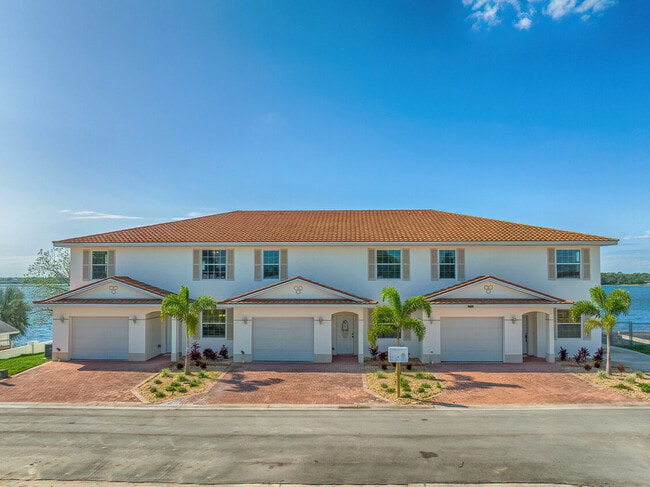


This Property Is For Sale
NEARBY LISTINGS FOR SALE OR LEASE
Property Detail
1900 Oasis Blvd
Sebring, FL
Knickerbocker Manor
S-17-34-29-040-0000-0010
KNICKERBOCKER MANOR 2/137 LOTS 1 + 8-LESS ELY 12 FT + ALL LOTS 2-3-4-5-6-7 BLK 347 + CLOSED RD PER OR 327 PG 564 + DINNER LAKE SUBURB TB-PG 3A ELY 38.4 FT M/L OF LOT 100 + CLOSED RD PER OR 327-564
Sfr
Highlands
AE
Florida
12055C0139C
2
2024
2.55 AC
2025
Florida Central South Area
960800
Other Market Areas
8,819 SF
DEMOGRAPHICS near 1900 Oasis Blvd
1 mile
3 mile
5 mile
2024 Total Population
1,438
16,942
45,710
2029 Population
1,567
18,595
49,939
Pop Growth 2024-2029
+ 8.97%
+ 9.76%
+ 9.25%
Average Age
43
50
51
2024 Total Households
611
7,591
20,709
HH Growth 2024-2029
+ 9.17%
+ 10.09%
+ 9.41%
Median Household Inc
$39,721
$48,858
$48,615
Avg Household Size
2.20
2.10
2.10
2024 Avg HH Vehicles
2.00
1.00
1.00
Median Home Value
$126,136
$152,960
$144,362
Median Year Built
1974
1981
1985
Nearby Places
Map Layers
Map Styles
 Street
 Aerial
Transit
 Traffic
 Biking
Places
Listings with unknown addresses are not visible on the map
- Restaurants
- Banks
- Shops
- Fitness
- Groceries
PUBLIC TRANSPORTATION
COMMUTER RAIL
Sebring Amtrak Station (Silver Meteor - Amtrak, Silver Star - Amtrak)
Drive
Walk
Distance
Sebring Amtrak Station (Silver Meteor - Amtrak, Silver Star - Amtrak)
5 min
2.8 mi
Freight Ports
Port of Tampa Bay
Drive
Walk
Distance
Port of Tampa Bay
123 min
87.4 mi
Nearby Properties
Address
Land Use
TOTAL SIZE
Lot Size
Zoning
Address
Land Use
TOTAL SIZE
Lot Size
Zoning
235,165 SF
33.99 AC
B3
Address
Land Use
TOTAL SIZE
Lot Size
Zoning
224,707 SF
31.63 AC
PU
Address
Land Use
TOTAL SIZE
Lot Size
Zoning
114,905 SF
3.34 AC
PU
Address
Land Use
TOTAL SIZE
Lot Size
Zoning
155,486 SF
21.71 AC
C1
Address
Land Use
TOTAL SIZE
Lot Size
Zoning
91,734 SF
2.23 AC
R3
Address
Land Use
TOTAL SIZE
Lot Size
Zoning
114,960 SF
6.68 AC
PU
Address
Land Use
TOTAL SIZE
Lot Size
Zoning
104,876 SF
33.52 AC
B3
Address
Land Use
TOTAL SIZE
Lot Size
Zoning
9,464 SF
60.05 AC
M2
Address
Land Use
TOTAL SIZE
Lot Size
Zoning
7,620 SF
31.56 AC
M2
Address
Land Use
TOTAL SIZE
Lot Size
Zoning
320 SF
10.93 AC
C1
Address
Land Use
TOTAL SIZE
Lot Size
Zoning
78,313 SF
18.85 AC
PU
Address
Land Use
TOTAL SIZE
Lot Size
Zoning
137,240 SF
14.46 AC
B3
Address
Land Use
TOTAL SIZE
Lot Size
Zoning
78,361 SF
3.12 AC
PU
Address
Land Use
TOTAL SIZE
Lot Size
Zoning
18.90 AC
M2
Address
Land Use
TOTAL SIZE
Lot Size
Zoning
57,978 SF
3.80 AC
MUQD
Address
Land Use
TOTAL SIZE
Lot Size
Zoning
73,229 SF
14.19 AC
PU
Address
Land Use
TOTAL SIZE
Lot Size
Zoning
64,124 SF
4.16 AC
PU
Address
Land Use
TOTAL SIZE
Lot Size
Zoning
55,072 SF
5.16 AC
MUQD
Address
Land Use
TOTAL SIZE
Lot Size
Zoning
54.47 AC
M2CU
Address
Land Use
TOTAL SIZE
Lot Size
Zoning
102,610 SF
5.06 AC
C1
Address
Land Use
TOTAL SIZE
Lot Size
Zoning
55,344 SF
8.15 AC
C1
Address
Land Use
TOTAL SIZE
Lot Size
Zoning
53,846 SF
2.03 AC
C1
Address
Land Use
TOTAL SIZE
Lot Size
Zoning
3,111 SF
18.55 AC
CG3
Address
Land Use
TOTAL SIZE
Lot Size
Zoning
49,983 SF
7.31 AC
MUQD
Address
Land Use
TOTAL SIZE
Lot Size
Zoning
65,640 SF
6.89 AC
MUQD
Address
Land Use
TOTAL SIZE
Lot Size
Zoning
30,282 SF
2.75 AC
MUQD
Address
Land Use
TOTAL SIZE
Lot Size
Zoning
82,768 SF
30.95 AC
PU
Address
Land Use
TOTAL SIZE
Lot Size
Zoning
25,733 SF
1.09 AC
R3
Address
Land Use
TOTAL SIZE
Lot Size
Zoning
32,505 SF
9.84 AC
R1
Address
Land Use
TOTAL SIZE
Lot Size
Zoning
30,165 SF
2.89 AC
R1A
The World's #1 Commercial Real Estate Marketplace
Connect with us
© 2026 CoStar Group
The information above has been obtained from sources believed reliable. While we do not doubt its accuracy we have not verified it and make no guarantee, warranty or representation about it. It is your responsibility to independently confirm its accuracy and completeness. Any projections, opinions, assumptions, or estimates used are for example only and do not represent the current or future performance of the property. The value of this transaction to you depends on tax and other factors which should be evaluated by your tax, financial, and legal advisors. You and your advisors should conduct a careful, independent investigation of the property to determine to your satisfaction the suitability of the property for your needs.