Property Record
1900 Ogden Rd, Montrose, CO 81401


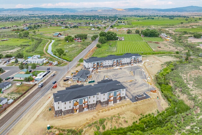
Property Detail
1900 Ogden Rd
Montrose, CO
S: 4 T: 48 R: 9 THAT PT OF THE NORTH 1/2 OF US GOVT LOT 16 SEC 4 LYING WLY OF THE LOUTSENHIZER CANAL AS PRESENTLY
R0004684
Montrose
Apartment
Colorado
AE The base floodplain where base flood elevations are provided. AE Zones are now used on new format FIRMs instead of A1-A30 Zones.
16
0
7.24 AC
2025
Colorado Southwest Area
966501
Other Market Areas
32,704 SF
NEARBY LISTINGS FOR SALE OR LEASE
-
-
View all Montrose listings for sale on LoopNet.com
DEMOGRAPHICS near 1900 Ogden Rd
1 mile
3 mile
5 mile
2025 Total Population
1,939
23,356
31,635
2030 Population
2,044
24,421
33,135
Pop Growth 2025-2030
+ 5.42%
+ 4.56%
+ 4.74%
Average Age
50
44
44
2025 Total Households
930
10,002
13,199
HH Growth 2025-2030
+ 5.38%
+ 4.58%
+ 4.76%
Median Household Inc
$57,583
$69,720
$71,625
Avg Household Size
2.00
2.30
2.30
2025 Avg HH Vehicles
2.00
2.00
2.00
Median Home Value
$432,083
$393,999
$385,080
Median Year Built
1996
1992
1993
Nearby Places
Map Layers
Map Styles
 Street
 Aerial
Transit
 Traffic
 Biking
Places
Listings with unknown addresses are not visible on the map
- Restaurants
- Banks
- Shops
- Fitness
- Groceries
PUBLIC TRANSPORTATION
AIRPORT
Montrose Regional
Drive
Walk
Distance
Montrose Regional
15 min
6.0 mi
Freight Ports
Port of San Diego
Drive
Walk
Distance
Port of San Diego
954 min
899.9 mi
Nearby Properties
Address
Land Use
TOTAL SIZE
Lot Size
Zoning
Address
Land Use
TOTAL SIZE
Lot Size
Zoning
229,488 SF
Address
Land Use
TOTAL SIZE
Lot Size
Zoning
82,754 SF
21.29 AC
Address
Land Use
TOTAL SIZE
Lot Size
Zoning
104,240 SF
29.39 AC
Address
Land Use
TOTAL SIZE
Lot Size
Zoning
84,927 SF
15.45 AC
Address
Land Use
TOTAL SIZE
Lot Size
Zoning
83,990 SF
Address
Land Use
TOTAL SIZE
Lot Size
Zoning
54,125 SF
18.15 AC
Address
Land Use
TOTAL SIZE
Lot Size
Zoning
93,240 SF
8.32 AC
Address
Land Use
TOTAL SIZE
Lot Size
Zoning
17,872 SF
2 AC
Address
Land Use
TOTAL SIZE
Lot Size
Zoning
52,533 SF
3.73 AC
Address
Land Use
TOTAL SIZE
Lot Size
Zoning
204,041 SF
17.30 AC
Address
Land Use
TOTAL SIZE
Lot Size
Zoning
63,757 SF
2.14 AC
Address
Land Use
TOTAL SIZE
Lot Size
Zoning
9,607 SF
17.78 AC
Address
Land Use
TOTAL SIZE
Lot Size
Zoning
128,307 SF
10.88 AC
Address
Land Use
TOTAL SIZE
Lot Size
Zoning
48,096 SF
33.43 AC
B2
Address
Land Use
TOTAL SIZE
Lot Size
Zoning
68,768 SF
7.73 AC
Address
Land Use
TOTAL SIZE
Lot Size
Zoning
51,727 SF
2.56 AC
Address
Land Use
TOTAL SIZE
Lot Size
Zoning
13,091 SF
0.86 AC
MR
Address
Land Use
TOTAL SIZE
Lot Size
Zoning
23,617 SF
16.03 AC
Address
Land Use
TOTAL SIZE
Lot Size
Zoning
33,554 SF
10 AC
Address
Land Use
TOTAL SIZE
Lot Size
Zoning
38,729 SF
3.83 AC
Address
Land Use
TOTAL SIZE
Lot Size
Zoning
97,056 SF
11.51 AC
Address
Land Use
TOTAL SIZE
Lot Size
Zoning
34,032 SF
1.56 AC
Address
Land Use
TOTAL SIZE
Lot Size
Zoning
250,620 SF
21.70 AC
Address
Land Use
TOTAL SIZE
Lot Size
Zoning
38,566 SF
2 AC
Address
Land Use
TOTAL SIZE
Lot Size
Zoning
26,915 SF
8.51 AC
Address
Land Use
TOTAL SIZE
Lot Size
Zoning
44,918 SF
4.49 AC
Address
Land Use
TOTAL SIZE
Lot Size
Zoning
55,624 SF
3.49 AC
Address
Land Use
TOTAL SIZE
Lot Size
Zoning
48,396 SF
7.94 AC
Address
Land Use
TOTAL SIZE
Lot Size
Zoning
18,441 SF
1.87 AC
The World's #1 Commercial Real Estate Marketplace
Connect with us
© 2026 CoStar Group
The information above has been obtained from sources believed reliable. While we do not doubt its accuracy we have not verified it and make no guarantee, warranty or representation about it. It is your responsibility to independently confirm its accuracy and completeness. Any projections, opinions, assumptions, or estimates used are for example only and do not represent the current or future performance of the property. The value of this transaction to you depends on tax and other factors which should be evaluated by your tax, financial, and legal advisors. You and your advisors should conduct a careful, independent investigation of the property to determine to your satisfaction the suitability of the property for your needs.