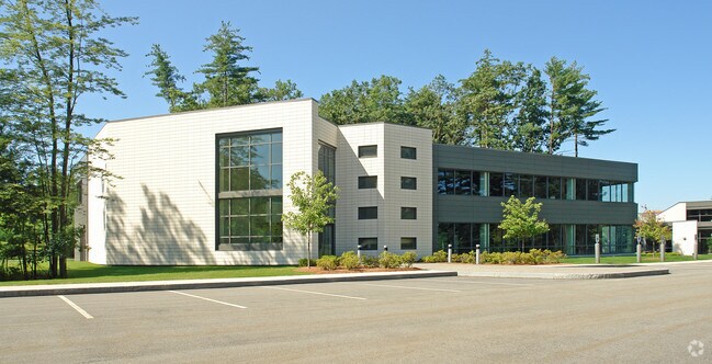
Property Record
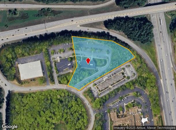
1900 Southwood Dr, Nashua, NH 03063
NEARBY LISTINGS FOR SALE OR LEASE
Property Detail
1900 Southwood Dr
NASH-000000-000000-000690G
Hillsborough
Officebuilding
New Hampshire
X
690
33011C0511D
4.60 AC
2024
Hillsborough
2024
Boston
010201
Manchester-Nashua, NH
19,794 SF
DEMOGRAPHICS near 1900 Southwood Dr
1 Mile
3 Mile
5 Mile
2024 Total Population
6,362
51,063
114,152
2029 Population
6,495
52,217
116,811
Pop Growth 2024-2029
+ 2.09%
+ 2.26%
+ 2.33%
Average Age
42
41
42
2024 Total Households
2,889
21,650
46,124
HH Growth 2024-2029
+ 2.15%
+ 2.33%
+ 2.36%
Median Household Inc
$97,696
$83,422
$94,623
Avg Household Size
2.20
2.30
2.40
2024 Avg HH Vehicles
2.00
2.00
2.00
Median Home Value
$338,951
$356,679
$366,194
Median Year Built
1983
1973
1975
Nearby Places
Map Layers
Map Styles
 Street
 Aerial
- Restaurants
- Banks
- Shops
- Fitness
- Groceries
PUBLIC TRANSPORTATION
AIRPORT
Manchester Boston Regional
DRIVE
WALK
Distance
Manchester Boston Regional
21 min
13.1 mi
General Edward Lawrence Logan International
DRIVE
WALK
Distance
General Edward Lawrence Logan International
65 min
45.5 mi
Freight Ports
Port of Boston
DRIVE
WALK
Distance
Port of Boston
66 min
45.2 mi
SALE & LEASE HISTORY
LISTING DATE
SALE/LEASE

Dec 08, 2020
For Sale
Nearby Properties
Address
Land Use
TOTAL SIZE
Lot Size
Zoning
Address
Land Use
TOTAL SIZE
Lot Size
Zoning
29,295 SF
143.99 AC
INDUST
Address
Land Use
TOTAL SIZE
Lot Size
Zoning
19.70 AC
RB
Address
Land Use
TOTAL SIZE
Lot Size
Zoning
325.08 AC
AI
Address
Land Use
TOTAL SIZE
Lot Size
Zoning
60.25 AC
PI
Address
Land Use
TOTAL SIZE
Lot Size
Zoning
220,295 SF
4.34 AC
D1MU
Address
Land Use
TOTAL SIZE
Lot Size
Zoning
6.28 AC
INDUST
Address
Land Use
TOTAL SIZE
Lot Size
Zoning
576,827 SF
446.22 AC
INDUST
Address
Land Use
TOTAL SIZE
Lot Size
Zoning
26.55 AC
INDUST
Address
Land Use
TOTAL SIZE
Lot Size
Zoning
621,927 SF
106.62 AC
INDUST
Address
Land Use
TOTAL SIZE
Lot Size
Zoning
231,216 SF
1.88 AC
GIMU
Address
Land Use
TOTAL SIZE
Lot Size
Zoning
16.12 AC
RC
Address
Land Use
TOTAL SIZE
Lot Size
Zoning
15,975 SF
195.68 AC
INDUST
Address
Land Use
TOTAL SIZE
Lot Size
Zoning
183,432 SF
16.40 AC
GB
Address
Land Use
TOTAL SIZE
Lot Size
Zoning
124,048 SF
23.43 AC
PI
Address
Land Use
TOTAL SIZE
Lot Size
Zoning
8.87 AC
RC
Address
Land Use
TOTAL SIZE
Lot Size
Zoning
66 AC
R18
Address
Land Use
TOTAL SIZE
Lot Size
Zoning
74.50 AC
R9
Address
Land Use
TOTAL SIZE
Lot Size
Zoning
471,525 SF
40.78 AC
INDUST
Address
Land Use
TOTAL SIZE
Lot Size
Zoning
337,000 SF
24.26 AC
PI
Address
Land Use
TOTAL SIZE
Lot Size
Zoning
51,684 SF
36.58 AC
INDUST
Address
Land Use
TOTAL SIZE
Lot Size
Zoning
326,755 SF
43 AC
INDUST
Address
Land Use
TOTAL SIZE
Lot Size
Zoning
123,648 SF
135.87 AC
INDUST
Address
Land Use
TOTAL SIZE
Lot Size
Zoning
261,381 SF
3.78 AC
GIMU
Address
Land Use
TOTAL SIZE
Lot Size
Zoning
33.81 AC
PI
Address
Land Use
TOTAL SIZE
Lot Size
Zoning
9.50 AC
AI
Address
Land Use
TOTAL SIZE
Lot Size
Zoning
130,178 SF
11.07 AC
GB
Address
Land Use
TOTAL SIZE
Lot Size
Zoning
142,207 SF
4.72 AC
PI
Address
Land Use
TOTAL SIZE
Lot Size
Zoning
10.30 AC
RC
Address
Land Use
TOTAL SIZE
Lot Size
Zoning
141,816 SF
21.33 AC
R18
Address
Land Use
TOTAL SIZE
Lot Size
Zoning
9.01 AC
RC
The World's #1 Commercial Real Estate Marketplace
Connect with us
© 2025 CoStar Group
The information above has been obtained from sources believed reliable. While we do not doubt its accuracy we have not verified it and make no guarantee, warranty or representation about it. It is your responsibility to independently confirm its accuracy and completeness. Any projections, opinions, assumptions, or estimates used are for example only and do not represent the current or future performance of the property. The value of this transaction to you depends on tax and other factors which should be evaluated by your tax, financial, and legal advisors. You and your advisors should conduct a careful, independent investigation of the property to determine to your satisfaction the suitability of the property for your needs.