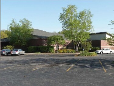
Property Record
1900 W Severs Rd, La Porte, IN 46350
NEARBY LISTINGS FOR SALE OR LEASE
Property Detail
1900 W Severs Rd
46-06-23-352-010.000-042
Severs Rd
Taxexempt
05-06-23-352-012IN SW1/4 S23 T37 R3 3.599AC PER SURVEY
X
La Porte
18091C0165D
Indiana
2023
3.60 AC
2025
South Bend/Elkhart
042000
Other Market Areas
7,592 SF
Michigan City-La Porte, IN
DEMOGRAPHICS near 1900 W Severs Rd
1 Mile
3 Mile
5 Mile
2024 Total Population
1,431
20,128
35,090
2029 Population
1,441
19,937
34,625
Pop Growth 2024-2029
+ 0.70%
(0.95%)
(1.33%)
Average Age
43
40
41
2024 Total Households
574
7,943
13,916
HH Growth 2024-2029
+ 0.52%
(1.10%)
(1.51%)
Median Household Inc
$71,874
$56,140
$62,662
Avg Household Size
2.50
2.40
2.40
2024 Avg HH Vehicles
2.00
2.00
2.00
Median Home Value
$247,471
$165,977
$179,541
Median Year Built
1982
1955
1963
Nearby Places
Map Layers
Map Styles
 Street
 Aerial
- Restaurants
- Banks
- Shops
- Fitness
- Groceries
PUBLIC TRANSPORTATION
COMMUTER RAIL
Carroll Avenue (Michigan City) Station (South Shore Line - Northern Indiana Commuter Transportation District (South Shore Line))
DRIVE
WALK
Distance
Carroll Avenue (Michigan City) Station (South Shore Line - Northern Indiana Commuter Transportation District (South Shore Line))
16 min
9.5 mi
AIRPORT
South Bend International
DRIVE
WALK
Distance
South Bend International
46 min
30.9 mi
SALE & LEASE HISTORY
LISTING DATE
SALE/LEASE

Sep 25, 2016
For Lease
Sep 09, 2022
For Lease
Aug 03, 2022
For Sale
Nearby Properties
Address
Land Use
TOTAL SIZE
Lot Size
Zoning
Address
Land Use
TOTAL SIZE
Lot Size
Zoning
Address
Land Use
TOTAL SIZE
Lot Size
Zoning
38,110 SF
5.25 AC
Address
Land Use
TOTAL SIZE
Lot Size
Zoning
93,819 SF
3.72 AC
Address
Land Use
TOTAL SIZE
Lot Size
Zoning
33,252 SF
49.97 AC
Address
Land Use
TOTAL SIZE
Lot Size
Zoning
150,000 SF
22.86 AC
Address
Land Use
TOTAL SIZE
Lot Size
Zoning
106,778 SF
15.78 AC
Address
Land Use
TOTAL SIZE
Lot Size
Zoning
86,550 SF
19.13 AC
Address
Land Use
TOTAL SIZE
Lot Size
Zoning
840 SF
18.96 AC
Address
Land Use
TOTAL SIZE
Lot Size
Zoning
63,583 SF
16.87 AC
Address
Land Use
TOTAL SIZE
Lot Size
Zoning
50,832 SF
14.26 AC
Address
Land Use
TOTAL SIZE
Lot Size
Zoning
9,940 SF
3.04 AC
Address
Land Use
TOTAL SIZE
Lot Size
Zoning
193,743 SF
17.50 AC
Address
Land Use
TOTAL SIZE
Lot Size
Zoning
33,562 SF
11.99 AC
Address
Land Use
TOTAL SIZE
Lot Size
Zoning
25,686 SF
2.68 AC
Address
Land Use
TOTAL SIZE
Lot Size
Zoning
51,910 SF
4.89 AC
Address
Land Use
TOTAL SIZE
Lot Size
Zoning
60,213 SF
11.46 AC
Address
Land Use
TOTAL SIZE
Lot Size
Zoning
46,345 SF
37.29 AC
Address
Land Use
TOTAL SIZE
Lot Size
Zoning
26,586 SF
6.15 AC
Address
Land Use
TOTAL SIZE
Lot Size
Zoning
19,230 SF
2.32 AC
Address
Land Use
TOTAL SIZE
Lot Size
Zoning
12,586 SF
32.14 AC
Address
Land Use
TOTAL SIZE
Lot Size
Zoning
23,470 SF
4.54 AC
Address
Land Use
TOTAL SIZE
Lot Size
Zoning
9,668 SF
54.34 AC
Address
Land Use
TOTAL SIZE
Lot Size
Zoning
13,378 SF
0.78 AC
Address
Land Use
TOTAL SIZE
Lot Size
Zoning
7,217 SF
0.40 AC
LBCCN
Address
Land Use
TOTAL SIZE
Lot Size
Zoning
4,200 SF
12.68 AC
Address
Land Use
TOTAL SIZE
Lot Size
Zoning
9,856 SF
1.28 AC
Address
Land Use
TOTAL SIZE
Lot Size
Zoning
6,615 SF
10 AC
Address
Land Use
TOTAL SIZE
Lot Size
Zoning
26,012 SF
3.77 AC
Address
Land Use
TOTAL SIZE
Lot Size
Zoning
69,350 SF
2 AC
Address
Land Use
TOTAL SIZE
Lot Size
Zoning
2,040 SF
4.69 AC
The World's #1 Commercial Real Estate Marketplace
Connect with us
© 2026 CoStar Group
The information above has been obtained from sources believed reliable. While we do not doubt its accuracy we have not verified it and make no guarantee, warranty or representation about it. It is your responsibility to independently confirm its accuracy and completeness. Any projections, opinions, assumptions, or estimates used are for example only and do not represent the current or future performance of the property. The value of this transaction to you depends on tax and other factors which should be evaluated by your tax, financial, and legal advisors. You and your advisors should conduct a careful, independent investigation of the property to determine to your satisfaction the suitability of the property for your needs.