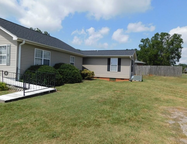
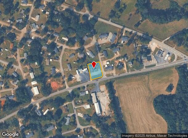
Property Record
1900 Whitehall Rd, Anderson, SC 29625
NEARBY LISTINGS FOR SALE OR LEASE
Property Detail
1900 Whitehall Rd
095-07-04-004
Centerville Terr
Officebuilding
CP 110/148 F105 D134 PP 055/027 WHITEHALL RD .47 AC
X
Anderson
45007C0240E
South Carolina
2025
0.47 AC
2024
Anderson Cy S of I-85
011002
Greenville/Spartanburg
1,875 SF
Greenville-Anderson-Mauldin, SC
DEMOGRAPHICS near 1900 Whitehall Rd
1 Mile
3 Mile
5 Mile
2024 Total Population
3,991
22,403
56,296
2029 Population
4,220
23,895
60,377
Pop Growth 2024-2029
+ 5.74%
+ 6.66%
+ 7.25%
Average Age
43
41
41
2024 Total Households
1,622
9,457
23,315
HH Growth 2024-2029
+ 5.80%
+ 6.73%
+ 7.36%
Median Household Inc
$61,707
$54,706
$51,273
Avg Household Size
2.40
2.30
2.30
2024 Avg HH Vehicles
2.00
2.00
2.00
Median Home Value
$176,679
$165,704
$175,210
Median Year Built
1991
1986
1982
Nearby Places
Map Layers
Map Styles
 Street
 Aerial
- Restaurants
- Banks
- Shops
- Fitness
- Groceries
PUBLIC TRANSPORTATION
AIRPORT
Greenville Spartanburg International
DRIVE
WALK
Distance
Greenville Spartanburg International
56 min
42.5 mi
SALE & LEASE HISTORY
LISTING DATE
SALE/LEASE

Sep 29, 2023
For Sale
May 08, 2017
For Lease
Aug 17, 2022
For Lease
Apr 04, 2022
For Sale
Nearby Properties
Address
Land Use
TOTAL SIZE
Lot Size
Zoning
Address
Land Use
TOTAL SIZE
Lot Size
Zoning
27,519 SF
20.80 AC
Address
Land Use
TOTAL SIZE
Lot Size
Zoning
152,326 SF
25.37 AC
Address
Land Use
TOTAL SIZE
Lot Size
Zoning
2,778 SF
12.37 AC
Address
Land Use
TOTAL SIZE
Lot Size
Zoning
2,027 SF
12.16 AC
Address
Land Use
TOTAL SIZE
Lot Size
Zoning
21,030 SF
13.10 AC
Address
Land Use
TOTAL SIZE
Lot Size
Zoning
27,441 SF
5.49 AC
Address
Land Use
TOTAL SIZE
Lot Size
Zoning
118,242 SF
10.63 AC
Address
Land Use
TOTAL SIZE
Lot Size
Zoning
121,900 SF
11.39 AC
Address
Land Use
TOTAL SIZE
Lot Size
Zoning
53,002 SF
15.97 AC
Address
Land Use
TOTAL SIZE
Lot Size
Zoning
138.61 AC
Address
Land Use
TOTAL SIZE
Lot Size
Zoning
134,827 SF
14.32 AC
Address
Land Use
TOTAL SIZE
Lot Size
Zoning
102,816 SF
28.36 AC
Address
Land Use
TOTAL SIZE
Lot Size
Zoning
63,040 SF
5.61 AC
Address
Land Use
TOTAL SIZE
Lot Size
Zoning
2,078 SF
44.20 AC
Address
Land Use
TOTAL SIZE
Lot Size
Zoning
71,500 SF
11.88 AC
Address
Land Use
TOTAL SIZE
Lot Size
Zoning
58,862 SF
6.89 AC
Address
Land Use
TOTAL SIZE
Lot Size
Zoning
101,818 SF
11.78 AC
Address
Land Use
TOTAL SIZE
Lot Size
Zoning
23,043 SF
11.32 AC
Address
Land Use
TOTAL SIZE
Lot Size
Zoning
62,610 SF
10.50 AC
Address
Land Use
TOTAL SIZE
Lot Size
Zoning
29,814 SF
4.57 AC
Address
Land Use
TOTAL SIZE
Lot Size
Zoning
42,922 SF
6.57 AC
Address
Land Use
TOTAL SIZE
Lot Size
Zoning
30,250 SF
2 AC
Address
Land Use
TOTAL SIZE
Lot Size
Zoning
6,325 SF
4.84 AC
Address
Land Use
TOTAL SIZE
Lot Size
Zoning
22,266 SF
4.13 AC
Address
Land Use
TOTAL SIZE
Lot Size
Zoning
43,241 SF
7.21 AC
Address
Land Use
TOTAL SIZE
Lot Size
Zoning
9.51 AC
Address
Land Use
TOTAL SIZE
Lot Size
Zoning
60,340 SF
7.53 AC
Address
Land Use
TOTAL SIZE
Lot Size
Zoning
533,102 SF
66.26 AC
Address
Land Use
TOTAL SIZE
Lot Size
Zoning
40,280 SF
3.42 AC
Address
Land Use
TOTAL SIZE
Lot Size
Zoning
4,032 SF
1.12 AC
The World's #1 Commercial Real Estate Marketplace
Connect with us
© 2025 CoStar Group
The information above has been obtained from sources believed reliable. While we do not doubt its accuracy we have not verified it and make no guarantee, warranty or representation about it. It is your responsibility to independently confirm its accuracy and completeness. Any projections, opinions, assumptions, or estimates used are for example only and do not represent the current or future performance of the property. The value of this transaction to you depends on tax and other factors which should be evaluated by your tax, financial, and legal advisors. You and your advisors should conduct a careful, independent investigation of the property to determine to your satisfaction the suitability of the property for your needs.