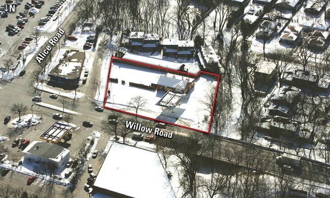
Property Record
1900 Willow Rd, Winnetka, IL 60093

Save to a Folder
{{folder.Name}}
{{folder.ListingIds.length}} Properties
{{folder.ListingIds.length}} Property
Create a New Folder
Property Detail
1900 Willow Rd
04-24-413-078-0000
COOK
Commercialbuilding
Illinois
AE The base floodplain where base flood elevations are provided. AE Zones are now used on new format FIRMs instead of A1-A30 Zones.
2
2023
0.73 AC
2025
Central North
800500
Chicago
7,088 SF
Chicago-Naperville-Elgin, IL-IN
NEARBY LISTINGS FOR SALE OR LEASE
DEMOGRAPHICS near 1900 Willow Rd
1 mile
3 mile
5 mile
2025 Total Population
5,333
76,025
249,996
2030 Population
5,421
76,990
252,534
Pop Growth 2025-2030
+ 1.65%
+ 1.27%
+ 1.02%
Average Age
44
43
44
2025 Total Households
1,950
27,198
90,471
HH Growth 2025-2030
+ 1.49%
+ 1.21%
+ 0.86%
Median Household Inc
$168,619
$169,758
$131,192
Avg Household Size
2.70
2.70
2.70
2025 Avg HH Vehicles
2.00
2.00
2.00
Median Home Value
$776,705
$800,169
$583,850
Median Year Built
1968
1964
1963
Nearby Places
Map Layers
Map Styles
 Street
 Aerial
Layers
 Traffic
 Biking
Places
Listings with unknown addresses are not visible on the map
- Restaurants
- Banks
- Shops
- Fitness
- Groceries
PUBLIC TRANSPORTATION
COMMUTER RAIL
Winnetka Station (Union Pacific North Line - Northeast Illinois Regional Commuter Railroad (Metra))
Drive
Walk
Distance
Winnetka Station (Union Pacific North Line - Northeast Illinois Regional Commuter Railroad (Metra))
8 min
2.5 mi
Hubbard Woods Station (Union Pacific North Line - Northeast Illinois Regional Commuter Railroad (Metra))
Drive
Walk
Distance
Hubbard Woods Station (Union Pacific North Line - Northeast Illinois Regional Commuter Railroad (Metra))
8 min
2.6 mi
AIRPORT
Chicago O'Hare International
Drive
Walk
Distance
Chicago O'Hare International
24 min
15.8 mi
Chicago Midway International
Drive
Walk
Distance
Chicago Midway International
37 min
28.9 mi
Freight Ports
Port of Baltimore
Drive
Walk
Distance
Port of Baltimore
1 min
617.0 mi
Nearby Properties
Address
Land Use
TOTAL SIZE
Lot Size
Zoning
Address
Land Use
TOTAL SIZE
Lot Size
Zoning
8.04 AC
Address
Land Use
TOTAL SIZE
Lot Size
Zoning
629,447 SF
3.96 AC
Address
Land Use
TOTAL SIZE
Lot Size
Zoning
579,162 SF
6.41 AC
Address
Land Use
TOTAL SIZE
Lot Size
Zoning
415,554 SF
7.51 AC
Address
Land Use
TOTAL SIZE
Lot Size
Zoning
14.11 AC
Address
Land Use
TOTAL SIZE
Lot Size
Zoning
172,538 SF
5.60 AC
Address
Land Use
TOTAL SIZE
Lot Size
Zoning
495,857 SF
19.55 AC
Address
Land Use
TOTAL SIZE
Lot Size
Zoning
10.58 AC
Address
Land Use
TOTAL SIZE
Lot Size
Zoning
230,886 SF
9.30 AC
Address
Land Use
TOTAL SIZE
Lot Size
Zoning
679,109 SF
24.46 AC
Address
Land Use
TOTAL SIZE
Lot Size
Zoning
6.90 AC
Address
Land Use
TOTAL SIZE
Lot Size
Zoning
27.59 AC
Address
Land Use
TOTAL SIZE
Lot Size
Zoning
58,280 SF
3.46 AC
Address
Land Use
TOTAL SIZE
Lot Size
Zoning
193,804 SF
7.98 AC
Address
Land Use
TOTAL SIZE
Lot Size
Zoning
169,657 SF
7.25 AC
Address
Land Use
TOTAL SIZE
Lot Size
Zoning
251,385 SF
17.46 AC
Address
Land Use
TOTAL SIZE
Lot Size
Zoning
18.69 AC
Address
Land Use
TOTAL SIZE
Lot Size
Zoning
172,544 SF
7.22 AC
Address
Land Use
TOTAL SIZE
Lot Size
Zoning
206,139 SF
2.19 AC
Address
Land Use
TOTAL SIZE
Lot Size
Zoning
78,819 SF
5.86 AC
Address
Land Use
TOTAL SIZE
Lot Size
Zoning
189,892 SF
Address
Land Use
TOTAL SIZE
Lot Size
Zoning
17.91 AC
Address
Land Use
TOTAL SIZE
Lot Size
Zoning
114,174 SF
16.77 AC
Address
Land Use
TOTAL SIZE
Lot Size
Zoning
97.02 AC
Address
Land Use
TOTAL SIZE
Lot Size
Zoning
126.61 AC
Address
Land Use
TOTAL SIZE
Lot Size
Zoning
179.20 AC
Address
Land Use
TOTAL SIZE
Lot Size
Zoning
182,945 SF
2.51 AC
Address
Land Use
TOTAL SIZE
Lot Size
Zoning
71,565 SF
6.17 AC
Address
Land Use
TOTAL SIZE
Lot Size
Zoning
94,063 SF
1.61 AC
Address
Land Use
TOTAL SIZE
Lot Size
Zoning
108,890 SF
8.87 AC
The World's #1 Commercial Real Estate Marketplace
Connect with us
© 2026 CoStar Group
The information above has been obtained from sources believed reliable. While we do not doubt its accuracy we have not verified it and make no guarantee, warranty or representation about it. It is your responsibility to independently confirm its accuracy and completeness. Any projections, opinions, assumptions, or estimates used are for example only and do not represent the current or future performance of the property. The value of this transaction to you depends on tax and other factors which should be evaluated by your tax, financial, and legal advisors. You and your advisors should conduct a careful, independent investigation of the property to determine to your satisfaction the suitability of the property for your needs.