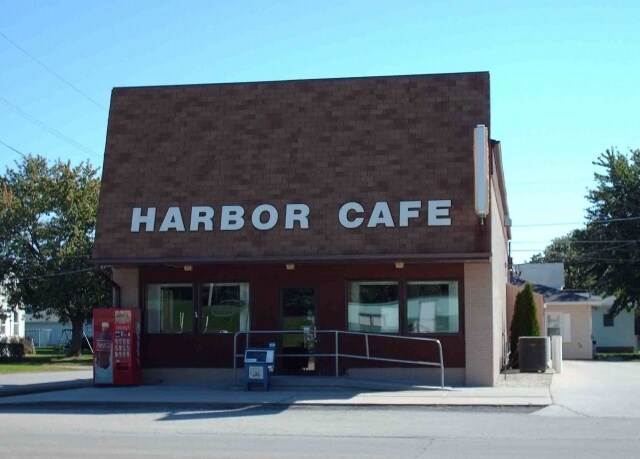
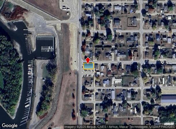
Property Record
1901 4Th St, Fulton, IL 61252

NEARBY LISTINGS FOR SALE OR LEASE
-
-
No Photo
-
-
View all Fulton listings for sale on LoopNet.com
Property Detail
1901 4Th St
Sterling, IL
Blakes Addition
0128355001
BLAKES ADDITION LOT 1 & N 1/2 LOT 2 BLK 4 122500X
Commercialnec
Whiteside
X
Illinois
19045C0506F
1-2
2024
0.14 AC
2024
Illinois North Area
000500
Other Market Areas
DEMOGRAPHICS near 1901 4Th St
1 mile
3 mile
5 mile
2024 Total Population
3,322
24,646
29,995
2029 Population
3,259
24,730
30,016
Pop Growth 2024-2029
(1.90%)
+ 0.34%
+ 0.07%
Average Age
42
42
42
2024 Total Households
1,469
10,556
12,841
HH Growth 2024-2029
(1.91%)
+ 0.33%
+ 0.05%
Median Household Inc
$48,848
$49,572
$50,798
Avg Household Size
2.20
2.20
2.20
2024 Avg HH Vehicles
2.00
2.00
2.00
Median Home Value
$103,900
$113,143
$118,611
Median Year Built
1954
1952
1953
Nearby Places
Map Layers
Map Styles
 Street
 Aerial
Transit
 Traffic
 Biking
Places
Listings with unknown addresses are not visible on the map
- Restaurants
- Banks
- Shops
- Fitness
- Groceries
PUBLIC TRANSPORTATION
AIRPORT
Quad Cities International
Drive
Walk
Distance
Quad Cities International
64 min
40.1 mi
SALE & LEASE HISTORY
LISTING DATE
SALE/LEASE

Sep 24, 2016
For Sale
Jul 19, 2017
For Sale
Aug 03, 2017
For Sale
Nearby Properties
Address
Land Use
TOTAL SIZE
Lot Size
Zoning
Address
Land Use
TOTAL SIZE
Lot Size
Zoning
165,649 SF
8.31 AC
Address
Land Use
TOTAL SIZE
Lot Size
Zoning
276,147 SF
15.22 AC
Address
Land Use
TOTAL SIZE
Lot Size
Zoning
61,488 SF
33.25 AC
Address
Land Use
TOTAL SIZE
Lot Size
Zoning
4.80 AC
Address
Land Use
TOTAL SIZE
Lot Size
Zoning
2,244 SF
42.56 AC
Address
Land Use
TOTAL SIZE
Lot Size
Zoning
76,937 SF
8.26 AC
Address
Land Use
TOTAL SIZE
Lot Size
Zoning
12,600 SF
40.27 AC
Address
Land Use
TOTAL SIZE
Lot Size
Zoning
36.01 AC
Address
Land Use
TOTAL SIZE
Lot Size
Zoning
4,970 SF
7.69 AC
Address
Land Use
TOTAL SIZE
Lot Size
Zoning
112,935 SF
4.40 AC
Address
Land Use
TOTAL SIZE
Lot Size
Zoning
91,170 SF
3.75 AC
Address
Land Use
TOTAL SIZE
Lot Size
Zoning
38,760 SF
14.91 AC
Address
Land Use
TOTAL SIZE
Lot Size
Zoning
55,916 SF
10 AC
Address
Land Use
TOTAL SIZE
Lot Size
Zoning
85,930 SF
12 AC
Address
Land Use
TOTAL SIZE
Lot Size
Zoning
67,153 SF
3.16 AC
Address
Land Use
TOTAL SIZE
Lot Size
Zoning
960 SF
21.56 AC
Address
Land Use
TOTAL SIZE
Lot Size
Zoning
71,060 SF
7.36 AC
Address
Land Use
TOTAL SIZE
Lot Size
Zoning
2,286 SF
14.27 AC
Address
Land Use
TOTAL SIZE
Lot Size
Zoning
29,485 SF
5.17 AC
Address
Land Use
TOTAL SIZE
Lot Size
Zoning
18,078 SF
5.89 AC
Address
Land Use
TOTAL SIZE
Lot Size
Zoning
48,728 SF
0.48 AC
Address
Land Use
TOTAL SIZE
Lot Size
Zoning
38,240 SF
19.75 AC
Address
Land Use
TOTAL SIZE
Lot Size
Zoning
1,608 SF
2.24 AC
Address
Land Use
TOTAL SIZE
Lot Size
Zoning
45,410 SF
1.80 AC
Address
Land Use
TOTAL SIZE
Lot Size
Zoning
18,280 SF
58.43 AC
Address
Land Use
TOTAL SIZE
Lot Size
Zoning
44,716 SF
0.99 AC
Address
Land Use
TOTAL SIZE
Lot Size
Zoning
35,806 SF
4.13 AC
Address
Land Use
TOTAL SIZE
Lot Size
Zoning
55,006 SF
0.69 AC
Address
Land Use
TOTAL SIZE
Lot Size
Zoning
153,504 SF
148.23 AC
Address
Land Use
TOTAL SIZE
Lot Size
Zoning
18,360 SF
2.25 AC
The World's #1 Commercial Real Estate Marketplace
Connect with us
© 2026 CoStar Group
The information above has been obtained from sources believed reliable. While we do not doubt its accuracy we have not verified it and make no guarantee, warranty or representation about it. It is your responsibility to independently confirm its accuracy and completeness. Any projections, opinions, assumptions, or estimates used are for example only and do not represent the current or future performance of the property. The value of this transaction to you depends on tax and other factors which should be evaluated by your tax, financial, and legal advisors. You and your advisors should conduct a careful, independent investigation of the property to determine to your satisfaction the suitability of the property for your needs.