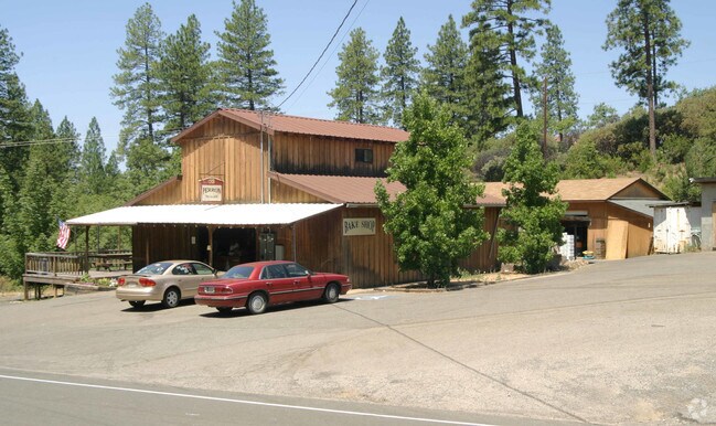
Property Record
1901 Carson Rd, Placerville, CA 95667

Property Detail
1901 Carson Rd
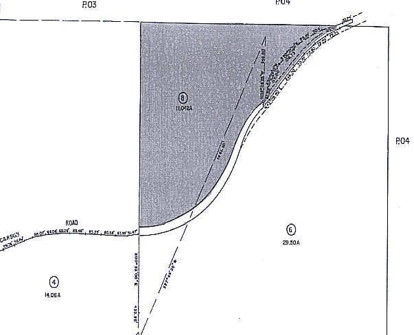
049-060-008-000
SEC 4 10 11
Storebuilding
EL DORADO
A
California
B and X Area of moderate flood hazard, usually the area between the limits of the 100-year and 500-year floods.
11.04 AC
2024
Outer El Dorado Cnty
2025
Sacramento
031100
Sacramento-Roseville-Folsom, CA
NEARBY LISTINGS FOR SALE OR LEASE
DEMOGRAPHICS near 1901 Carson Rd
1 mile
3 mile
5 mile
2024 Total Population
1,811
13,116
26,974
2029 Population
1,803
13,032
26,611
Pop Growth 2024-2029
(0.44%)
(0.64%)
(1.35%)
Average Age
46
46
46
2024 Total Households
781
5,596
11,265
HH Growth 2024-2029
(0.38%)
(0.64%)
(1.34%)
Median Household Inc
$97,813
$87,529
$87,224
Avg Household Size
2.30
2.30
2.30
2024 Avg HH Vehicles
2.00
2.00
2.00
Median Home Value
$649,336
$545,781
$544,978
Median Year Built
1972
1973
1978
Nearby Places
Map Layers
Map Styles
 Street
 Aerial
Transit
 Traffic
 Biking
Places
Listings with unknown addresses are not visible on the map
- Restaurants
- Banks
- Shops
- Fitness
- Groceries
Nearby Properties
Address
Land Use
TOTAL SIZE
Lot Size
Zoning
Address
Land Use
TOTAL SIZE
Lot Size
Zoning
201,296 SF
13 AC
Address
Land Use
TOTAL SIZE
Lot Size
Zoning
55,043 SF
2.57 AC
RE
Address
Land Use
TOTAL SIZE
Lot Size
Zoning
55,216 SF
6.60 AC
R106
Address
Land Use
TOTAL SIZE
Lot Size
Zoning
4,688 SF
12.28 AC
R106
Address
Land Use
TOTAL SIZE
Lot Size
Zoning
3,072 SF
3.83 AC
Address
Land Use
TOTAL SIZE
Lot Size
Zoning
61,936 SF
8.60 AC
Address
Land Use
TOTAL SIZE
Lot Size
Zoning
59,265 SF
7.65 AC
R2
Address
Land Use
TOTAL SIZE
Lot Size
Zoning
74,718 SF
2.08 AC
CG
Address
Land Use
TOTAL SIZE
Lot Size
Zoning
25,050 SF
2.08 AC
RE
Address
Land Use
TOTAL SIZE
Lot Size
Zoning
48,440 SF
5.11 AC
Address
Land Use
TOTAL SIZE
Lot Size
Zoning
5,764 SF
4.38 AC
PD
Address
Land Use
TOTAL SIZE
Lot Size
Zoning
28,830 SF
3.04 AC
R106
Address
Land Use
TOTAL SIZE
Lot Size
Zoning
2,215 SF
0.29 AC
Address
Land Use
TOTAL SIZE
Lot Size
Zoning
28,566 SF
2.14 AC
C
Address
Land Use
TOTAL SIZE
Lot Size
Zoning
26,417 SF
0.17 AC
C
Address
Land Use
TOTAL SIZE
Lot Size
Zoning
22,058 SF
2.40 AC
R2
Address
Land Use
TOTAL SIZE
Lot Size
Zoning
14,256 SF
0.25 AC
C
Address
Land Use
TOTAL SIZE
Lot Size
Zoning
36,504 SF
14.90 AC
RE
Address
Land Use
TOTAL SIZE
Lot Size
Zoning
18,125 SF
0.80 AC
C
Address
Land Use
TOTAL SIZE
Lot Size
Zoning
14,850 SF
1.51 AC
R2
Address
Land Use
TOTAL SIZE
Lot Size
Zoning
42,698 SF
0.87 AC
CG
Address
Land Use
TOTAL SIZE
Lot Size
Zoning
5,795 SF
0.42 AC
C
Address
Land Use
TOTAL SIZE
Lot Size
Zoning
37.46 AC
Address
Land Use
TOTAL SIZE
Lot Size
Zoning
4,410 SF
2.23 AC
PD
Address
Land Use
TOTAL SIZE
Lot Size
Zoning
9,722 SF
0.77 AC
C
Address
Land Use
TOTAL SIZE
Lot Size
Zoning
35,937 SF
0.83 AC
CG
Address
Land Use
TOTAL SIZE
Lot Size
Zoning
18,626 SF
2.38 AC
C
Address
Land Use
TOTAL SIZE
Lot Size
Zoning
18,315 SF
2.47 AC
C
Address
Land Use
TOTAL SIZE
Lot Size
Zoning
2,559 SF
25.29 AC
AE
The World's #1 Commercial Real Estate Marketplace
Connect with us
© 2026 CoStar Group
The information above has been obtained from sources believed reliable. While we do not doubt its accuracy we have not verified it and make no guarantee, warranty or representation about it. It is your responsibility to independently confirm its accuracy and completeness. Any projections, opinions, assumptions, or estimates used are for example only and do not represent the current or future performance of the property. The value of this transaction to you depends on tax and other factors which should be evaluated by your tax, financial, and legal advisors. You and your advisors should conduct a careful, independent investigation of the property to determine to your satisfaction the suitability of the property for your needs.