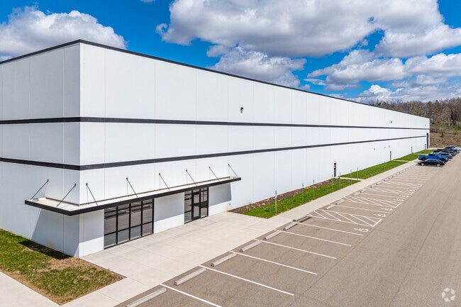
Property Record
1901 Gateway Blvd, Beloit, WI 53511

Property Detail
1901 Gateway Blvd
Janesville-Beloit, WI
PART OF THE EAST OF SECTION 21, TOWN 1 NORTH, RANGE 13 EAST OF THE 4TH P.M., CITY OF BELOIT, COUNTY OF ROCK, STATE OF WISCONS
221-40600
ROCK
Commercialnec
Wisconsin
AE The base floodplain where base flood elevations are provided. AE Zones are now used on new format FIRMs instead of A1-A30 Zones.
55.03 AC
2025
Rock County
2025
Milwaukee/Madison
002100
NEARBY LISTINGS FOR SALE OR LEASE
DEMOGRAPHICS near 1901 Gateway Blvd
1 mile
3 mile
5 mile
2025 Total Population
1,710
9,270
42,677
2030 Population
1,774
9,393
43,242
Pop Growth 2025-2030
+ 3.74%
+ 1.33%
+ 1.32%
Average Age
41
43
40
2025 Total Households
743
3,898
16,601
HH Growth 2025-2030
+ 3.63%
+ 1.36%
+ 1.37%
Median Household Inc
$83,912
$83,755
$67,887
Avg Household Size
2.30
2.30
2.40
2025 Avg HH Vehicles
2.00
2.00
2.00
Median Home Value
$306,069
$256,157
$214,744
Median Year Built
1994
1977
1966
Nearby Places
Map Layers
Map Styles
 Street
 Aerial
Transit
 Traffic
 Biking
Places
Listings with unknown addresses are not visible on the map
- Restaurants
- Banks
- Shops
- Fitness
- Groceries
PUBLIC TRANSPORTATION
AIRPORT
Chicago/Rockford International
Drive
Walk
Distance
Chicago/Rockford International
45 min
32.9 mi
Freight Ports
Port Milwaukee
Drive
Walk
Distance
Port Milwaukee
80 min
69.8 mi
SALE & LEASE HISTORY
LISTING DATE
SALE/LEASE

May 09, 2022
For Lease
May 06, 2024
For Sale
Nearby Properties
Address
Land Use
TOTAL SIZE
Lot Size
Zoning
Address
Land Use
TOTAL SIZE
Lot Size
Zoning
700,000 SF
80.08 AC
Address
Land Use
TOTAL SIZE
Lot Size
Zoning
264,000 SF
34 AC
Address
Land Use
TOTAL SIZE
Lot Size
Zoning
37.49 AC
CHI
Address
Land Use
TOTAL SIZE
Lot Size
Zoning
8.01 AC
Address
Land Use
TOTAL SIZE
Lot Size
Zoning
39.83 AC
Address
Land Use
TOTAL SIZE
Lot Size
Zoning
24.76 AC
Address
Land Use
TOTAL SIZE
Lot Size
Zoning
36,860 SF
11.26 AC
Address
Land Use
TOTAL SIZE
Lot Size
Zoning
61,820 SF
5.63 AC
Address
Land Use
TOTAL SIZE
Lot Size
Zoning
7.71 AC
Address
Land Use
TOTAL SIZE
Lot Size
Zoning
400,014 SF
43.71 AC
Address
Land Use
TOTAL SIZE
Lot Size
Zoning
32.08 AC
Address
Land Use
TOTAL SIZE
Lot Size
Zoning
141,745 SF
12.20 AC
Address
Land Use
TOTAL SIZE
Lot Size
Zoning
100,000 SF
14.54 AC
Address
Land Use
TOTAL SIZE
Lot Size
Zoning
233,850 SF
30.40 AC
Address
Land Use
TOTAL SIZE
Lot Size
Zoning
20.83 AC
Address
Land Use
TOTAL SIZE
Lot Size
Zoning
13.21 AC
Address
Land Use
TOTAL SIZE
Lot Size
Zoning
2,728 SF
10 AC
Address
Land Use
TOTAL SIZE
Lot Size
Zoning
231,166 SF
19.25 AC
Address
Land Use
TOTAL SIZE
Lot Size
Zoning
24.15 AC
Address
Land Use
TOTAL SIZE
Lot Size
Zoning
193,013 SF
22.93 AC
Address
Land Use
TOTAL SIZE
Lot Size
Zoning
22.90 AC
Address
Land Use
TOTAL SIZE
Lot Size
Zoning
100,000 SF
14.78 AC
Address
Land Use
TOTAL SIZE
Lot Size
Zoning
27.69 AC
Address
Land Use
TOTAL SIZE
Lot Size
Zoning
16.81 AC
Address
Land Use
TOTAL SIZE
Lot Size
Zoning
30,000 SF
3.31 AC
Address
Land Use
TOTAL SIZE
Lot Size
Zoning
101,660 SF
10.14 AC
Address
Land Use
TOTAL SIZE
Lot Size
Zoning
3.30 AC
Address
Land Use
TOTAL SIZE
Lot Size
Zoning
4.26 AC
Address
Land Use
TOTAL SIZE
Lot Size
Zoning
89,678 SF
12.90 AC
The World's #1 Commercial Real Estate Marketplace
Connect with us
© 2026 CoStar Group
The information above has been obtained from sources believed reliable. While we do not doubt its accuracy we have not verified it and make no guarantee, warranty or representation about it. It is your responsibility to independently confirm its accuracy and completeness. Any projections, opinions, assumptions, or estimates used are for example only and do not represent the current or future performance of the property. The value of this transaction to you depends on tax and other factors which should be evaluated by your tax, financial, and legal advisors. You and your advisors should conduct a careful, independent investigation of the property to determine to your satisfaction the suitability of the property for your needs.