Property Record
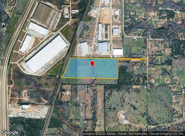
1901 High Meadows Way, Cedar Hill, TX 75104
NEARBY LISTINGS FOR SALE OR LEASE
Property Detail
1901 High Meadows Way
Dallas-Fort Worth-Arlington, TX
Hugh Robinson
65121829010150000
HUGH ROBINSON ABST 1218 PG 290 TR 15 ACS 46.0894 CALC JURIS SPLIT SEE ECAD # 193227 INT202100107472 DD04082021 CO-DC 1218290101500 5CH12182901
Privatepreserveopenspacevacantlandforestlandconservation
Dallas
X
Texas
48139C0040G
46.09 AC
2024
SW Dallas/US 67
2025
Dallas/Ft Worth
016626
DEMOGRAPHICS near 1901 High Meadows Way
1 Mile
3 Mile
5 Mile
2024 Total Population
574
21,992
75,296
2029 Population
605
22,805
81,177
Pop Growth 2024-2029
+ 5.40%
+ 3.70%
+ 7.81%
Average Age
36
37
38
2024 Total Households
181
7,203
25,207
HH Growth 2024-2029
+ 6.08%
+ 3.82%
+ 7.91%
Median Household Inc
$108,333
$86,592
$90,967
Avg Household Size
3.10
3.00
2.90
2024 Avg HH Vehicles
2.00
2.00
2.00
Median Home Value
$272,806
$260,029
$271,107
Median Year Built
2002
1993
1999
Nearby Places
Map Layers
Map Styles
 Street
 Aerial
- Restaurants
- Banks
- Shops
- Fitness
- Groceries
PUBLIC TRANSPORTATION
AIRPORT
Dallas Love Field
DRIVE
WALK
Distance
Dallas Love Field
37 min
25.6 mi
Dallas-Fort Worth International
DRIVE
WALK
Distance
Dallas-Fort Worth International
43 min
30.5 mi
Freight Ports
Port of Shreveport
DRIVE
WALK
Distance
Port of Shreveport
227 min
210.0 mi
Nearby Properties
Address
Land Use
TOTAL SIZE
Lot Size
Zoning
Address
Land Use
TOTAL SIZE
Lot Size
Zoning
1,108,080 SF
66.41 AC
Address
Land Use
TOTAL SIZE
Lot Size
Zoning
Address
Land Use
TOTAL SIZE
Lot Size
Zoning
1,108,080 SF
32.88 AC
Z109
Address
Land Use
TOTAL SIZE
Lot Size
Zoning
Address
Land Use
TOTAL SIZE
Lot Size
Zoning
420,000 SF
35.38 AC
Z109
Address
Land Use
TOTAL SIZE
Lot Size
Zoning
347,760 SF
21.61 AC
Z109
Address
Land Use
TOTAL SIZE
Lot Size
Zoning
308,880 SF
19.03 AC
Z109
Address
Land Use
TOTAL SIZE
Lot Size
Zoning
321,600 SF
19.58 AC
Z109
Address
Land Use
TOTAL SIZE
Lot Size
Zoning
224,000 SF
15.42 AC
Address
Land Use
TOTAL SIZE
Lot Size
Zoning
238,680 SF
5.12 AC
Z109
Address
Land Use
TOTAL SIZE
Lot Size
Zoning
152,144 SF
0.01 AC
AA1
Address
Land Use
TOTAL SIZE
Lot Size
Zoning
203,850 SF
15.84 AC
Address
Land Use
TOTAL SIZE
Lot Size
Zoning
156,000 SF
11.31 AC
Z14
Address
Land Use
TOTAL SIZE
Lot Size
Zoning
183,300 SF
12.96 AC
Address
Land Use
TOTAL SIZE
Lot Size
Zoning
164,480 SF
13.21 AC
Z111
Address
Land Use
TOTAL SIZE
Lot Size
Zoning
1,864.30 AC
Address
Land Use
TOTAL SIZE
Lot Size
Zoning
154,000 SF
14.49 AC
Z111
Address
Land Use
TOTAL SIZE
Lot Size
Zoning
149,430 SF
15.75 AC
Address
Land Use
TOTAL SIZE
Lot Size
Zoning
123,120 SF
10.02 AC
Z109
Address
Land Use
TOTAL SIZE
Lot Size
Zoning
72,530 SF
19.58 AC
Z360
Address
Land Use
TOTAL SIZE
Lot Size
Zoning
123,162 SF
61.28 AC
Z369
Address
Land Use
TOTAL SIZE
Lot Size
Zoning
120,774 SF
6.47 AC
Z160
Address
Land Use
TOTAL SIZE
Lot Size
Zoning
68,968 SF
24.79 AC
Z137
Address
Land Use
TOTAL SIZE
Lot Size
Zoning
100,000 SF
8.24 AC
Z111
Address
Land Use
TOTAL SIZE
Lot Size
Zoning
82,526 SF
19.28 AC
Z111
Address
Land Use
TOTAL SIZE
Lot Size
Zoning
131,554 SF
12.87 AC
Z137
Address
Land Use
TOTAL SIZE
Lot Size
Zoning
86,400 SF
7.28 AC
Z109
Address
Land Use
TOTAL SIZE
Lot Size
Zoning
77,875 SF
8.88 AC
Z111
Address
Land Use
TOTAL SIZE
Lot Size
Zoning
69,350 SF
13 AC
Z236
Address
Land Use
TOTAL SIZE
Lot Size
Zoning
81.39 AC
Z31
The World's #1 Commercial Real Estate Marketplace
Connect with us
© 2025 CoStar Group
The information above has been obtained from sources believed reliable. While we do not doubt its accuracy we have not verified it and make no guarantee, warranty or representation about it. It is your responsibility to independently confirm its accuracy and completeness. Any projections, opinions, assumptions, or estimates used are for example only and do not represent the current or future performance of the property. The value of this transaction to you depends on tax and other factors which should be evaluated by your tax, financial, and legal advisors. You and your advisors should conduct a careful, independent investigation of the property to determine to your satisfaction the suitability of the property for your needs.