Property Record
1901 Longwood Dr, Brenham, TX 77833
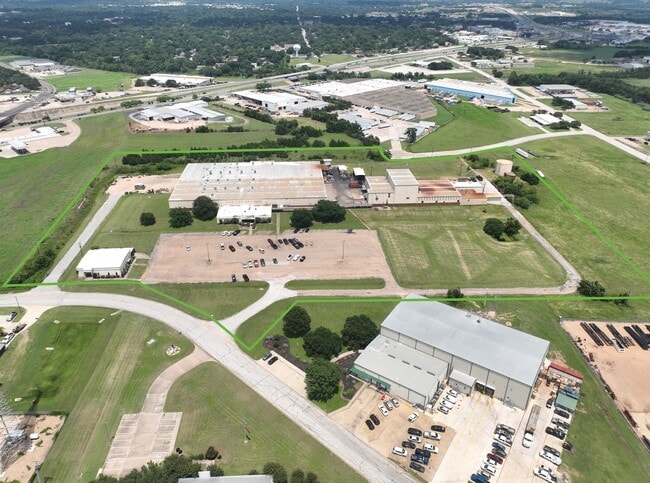

This Property Is For Sale
Property Detail
1901 Longwood Dr
Brenham, TX
A0031 COE, PHILIP, TRACT 315, ACRES 18.825, (INCLUDES SOUTHWEST INDUSTRIAL PARK II, RES B LOT 1)
0031-000-31500
Washington
Industrialgeneral
Texas
B and X Area of moderate flood hazard, usually the area between the limits of the 100-year and 500-year floods.
1
2025
18.83 AC
2025
Central Texas Area
170400
Other Market Areas
109,500 SF
NEARBY LISTINGS FOR SALE OR LEASE
DEMOGRAPHICS near 1901 Longwood Dr
1 mile
3 mile
5 mile
2025 Total Population
3,151
20,158
23,991
2030 Population
3,318
21,205
25,200
Pop Growth 2025-2030
+ 5.30%
+ 5.19%
+ 5.04%
Average Age
34
40
40
2025 Total Households
742
7,507
8,975
HH Growth 2025-2030
+ 4.72%
+ 5.83%
+ 5.73%
Median Household Inc
$60,785
$59,830
$62,658
Avg Household Size
2.40
2.30
2.40
2025 Avg HH Vehicles
2.00
2.00
2.00
Median Home Value
$234,574
$256,753
$269,961
Median Year Built
1983
1986
1988
Nearby Places
Map Layers
Map Styles
 Street
 Aerial
Layers
 Traffic
 Biking
Places
Listings with unknown addresses are not visible on the map
- Restaurants
- Banks
- Shops
- Fitness
- Groceries
PUBLIC TRANSPORTATION
AIRPORT
Easterwood Field
Drive
Walk
Distance
Easterwood Field
67 min
43.8 mi
Nearby Properties
Address
Land Use
TOTAL SIZE
Lot Size
Zoning
Address
Land Use
TOTAL SIZE
Lot Size
Zoning
172,665 SF
12.76 AC
Address
Land Use
TOTAL SIZE
Lot Size
Zoning
91,028 SF
3.94 AC
Address
Land Use
TOTAL SIZE
Lot Size
Zoning
Address
Land Use
TOTAL SIZE
Lot Size
Zoning
118,557 SF
11.53 AC
Address
Land Use
TOTAL SIZE
Lot Size
Zoning
112,603 SF
35.85 AC
Address
Land Use
TOTAL SIZE
Lot Size
Zoning
230,486 SF
23.85 AC
Address
Land Use
TOTAL SIZE
Lot Size
Zoning
101,192 SF
3.77 AC
Address
Land Use
TOTAL SIZE
Lot Size
Zoning
92,565 SF
17.45 AC
Address
Land Use
TOTAL SIZE
Lot Size
Zoning
159,878 SF
22.46 AC
Address
Land Use
TOTAL SIZE
Lot Size
Zoning
106,211 SF
48.30 AC
Address
Land Use
TOTAL SIZE
Lot Size
Zoning
92,469 SF
8.76 AC
Address
Land Use
TOTAL SIZE
Lot Size
Zoning
63,402 SF
5.97 AC
Address
Land Use
TOTAL SIZE
Lot Size
Zoning
76,425 SF
39.31 AC
Address
Land Use
TOTAL SIZE
Lot Size
Zoning
198.27 AC
Address
Land Use
TOTAL SIZE
Lot Size
Zoning
86,974 SF
4.31 AC
Address
Land Use
TOTAL SIZE
Lot Size
Zoning
69,686 SF
14.68 AC
Address
Land Use
TOTAL SIZE
Lot Size
Zoning
42,642 SF
6.30 AC
Address
Land Use
TOTAL SIZE
Lot Size
Zoning
75,230 SF
7.04 AC
Address
Land Use
TOTAL SIZE
Lot Size
Zoning
104,743 SF
15.63 AC
Address
Land Use
TOTAL SIZE
Lot Size
Zoning
68,357 SF
6.70 AC
Address
Land Use
TOTAL SIZE
Lot Size
Zoning
140.66 AC
Address
Land Use
TOTAL SIZE
Lot Size
Zoning
35,655 SF
52.35 AC
Address
Land Use
TOTAL SIZE
Lot Size
Zoning
111,434 SF
12.33 AC
Address
Land Use
TOTAL SIZE
Lot Size
Zoning
171,429 SF
7.08 AC
Address
Land Use
TOTAL SIZE
Lot Size
Zoning
44,318 SF
2.01 AC
Address
Land Use
TOTAL SIZE
Lot Size
Zoning
66,719 SF
3 AC
Address
Land Use
TOTAL SIZE
Lot Size
Zoning
34,722 SF
4.24 AC
Address
Land Use
TOTAL SIZE
Lot Size
Zoning
97,848 SF
7.66 AC
Address
Land Use
TOTAL SIZE
Lot Size
Zoning
57,899 SF
3.36 AC
Address
Land Use
TOTAL SIZE
Lot Size
Zoning
68,117 SF
7.83 AC
The World's #1 Commercial Real Estate Marketplace
Connect with us
© 2026 CoStar Group
The information above has been obtained from sources believed reliable. While we do not doubt its accuracy we have not verified it and make no guarantee, warranty or representation about it. It is your responsibility to independently confirm its accuracy and completeness. Any projections, opinions, assumptions, or estimates used are for example only and do not represent the current or future performance of the property. The value of this transaction to you depends on tax and other factors which should be evaluated by your tax, financial, and legal advisors. You and your advisors should conduct a careful, independent investigation of the property to determine to your satisfaction the suitability of the property for your needs.