Property Record
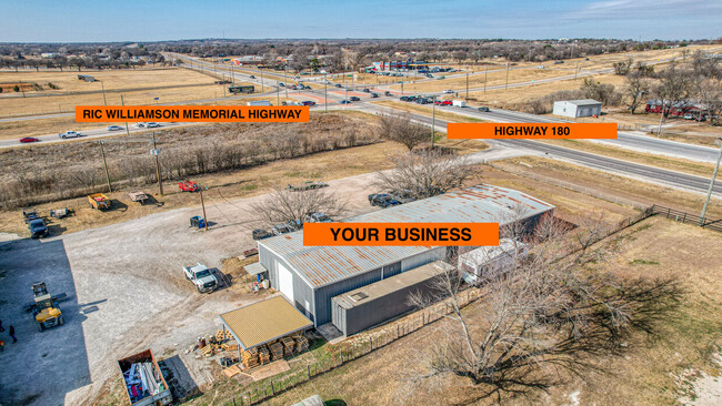
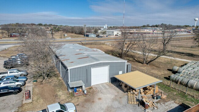
1901 Mineral Wells Hwy, Weatherford, TX 76088
Property Detail
1901 Mineral Wells Hwy
Dallas-Fort Worth-Arlington, TX
ACRES: 5.692 ABST: 1196, TR:, BLK:, SURV: GEORGE STAGGS
R000051422
Parker
Pasture
Texas
B and X Area of moderate flood hazard, usually the area between the limits of the 100-year and 500-year floods.
5.69 AC
2024
Parker County
2025
Dallas/Ft Worth
140300
NEARBY LISTINGS FOR SALE OR LEASE
DEMOGRAPHICS near 1901 Mineral Wells Hwy
1 mile
3 mile
5 mile
2025 Total Population
2,158
25,210
45,247
2030 Population
2,494
29,315
52,730
Pop Growth 2025-2030
+ 15.57%
+ 16.28%
+ 16.54%
Average Age
39
40
40
2025 Total Households
810
9,768
17,248
HH Growth 2025-2030
+ 14.69%
+ 15.57%
+ 15.85%
Median Household Inc
$82,222
$71,833
$73,770
Avg Household Size
2.50
2.50
2.50
2025 Avg HH Vehicles
2.00
2.00
2.00
Median Home Value
$324,117
$317,507
$330,741
Median Year Built
1977
1989
1997
Nearby Places
Map Layers
Map Styles
 Street
 Aerial
Layers
 Traffic
 Biking
Places
Listings with unknown addresses are not visible on the map
- Restaurants
- Banks
- Shops
- Fitness
- Groceries
SALE & LEASE HISTORY
LISTING DATE
SALE/LEASE

Mar 02, 2022
For Lease
Nearby Properties
Address
Land Use
TOTAL SIZE
Lot Size
Zoning
Address
Land Use
TOTAL SIZE
Lot Size
Zoning
279,600 SF
14.43 AC
Address
Land Use
TOTAL SIZE
Lot Size
Zoning
138,495 SF
13.83 AC
Address
Land Use
TOTAL SIZE
Lot Size
Zoning
103,600 SF
6 AC
Address
Land Use
TOTAL SIZE
Lot Size
Zoning
50,893 SF
10.37 AC
Address
Land Use
TOTAL SIZE
Lot Size
Zoning
210,698 SF
26.61 AC
Address
Land Use
TOTAL SIZE
Lot Size
Zoning
55,112 SF
4.68 AC
Address
Land Use
TOTAL SIZE
Lot Size
Zoning
81,112 SF
7.34 AC
Address
Land Use
TOTAL SIZE
Lot Size
Zoning
103,125 SF
18.25 AC
Address
Land Use
TOTAL SIZE
Lot Size
Zoning
155,253 SF
9.31 AC
Address
Land Use
TOTAL SIZE
Lot Size
Zoning
146,651 SF
7.73 AC
Address
Land Use
TOTAL SIZE
Lot Size
Zoning
109,420 SF
14.61 AC
Address
Land Use
TOTAL SIZE
Lot Size
Zoning
62,856 SF
5.17 AC
Address
Land Use
TOTAL SIZE
Lot Size
Zoning
22,356 SF
0.17 AC
Address
Land Use
TOTAL SIZE
Lot Size
Zoning
210,342 SF
5 AC
Address
Land Use
TOTAL SIZE
Lot Size
Zoning
56,052 SF
5.40 AC
Address
Land Use
TOTAL SIZE
Lot Size
Zoning
107,388 SF
6.62 AC
Address
Land Use
TOTAL SIZE
Lot Size
Zoning
55,236 SF
4.69 AC
Address
Land Use
TOTAL SIZE
Lot Size
Zoning
11,707 SF
40.10 AC
Address
Land Use
TOTAL SIZE
Lot Size
Zoning
25,496 SF
2.70 AC
Address
Land Use
TOTAL SIZE
Lot Size
Zoning
1,582 SF
0.58 AC
Address
Land Use
TOTAL SIZE
Lot Size
Zoning
33,650 SF
4 AC
Address
Land Use
TOTAL SIZE
Lot Size
Zoning
27,760 SF
10.50 AC
Address
Land Use
TOTAL SIZE
Lot Size
Zoning
78,870 SF
1.84 AC
Address
Land Use
TOTAL SIZE
Lot Size
Zoning
6,664 SF
7.32 AC
Address
Land Use
TOTAL SIZE
Lot Size
Zoning
30,777 SF
8.25 AC
Address
Land Use
TOTAL SIZE
Lot Size
Zoning
9,254 SF
13.39 AC
Address
Land Use
TOTAL SIZE
Lot Size
Zoning
180,371 SF
11.05 AC
Address
Land Use
TOTAL SIZE
Lot Size
Zoning
57,552 SF
7.93 AC
Address
Land Use
TOTAL SIZE
Lot Size
Zoning
30,320 SF
2.76 AC
Address
Land Use
TOTAL SIZE
Lot Size
Zoning
7,600 SF
0.85 AC
The World's #1 Commercial Real Estate Marketplace
Connect with us
© 2026 CoStar Group
The information above has been obtained from sources believed reliable. While we do not doubt its accuracy we have not verified it and make no guarantee, warranty or representation about it. It is your responsibility to independently confirm its accuracy and completeness. Any projections, opinions, assumptions, or estimates used are for example only and do not represent the current or future performance of the property. The value of this transaction to you depends on tax and other factors which should be evaluated by your tax, financial, and legal advisors. You and your advisors should conduct a careful, independent investigation of the property to determine to your satisfaction the suitability of the property for your needs.