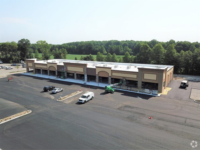
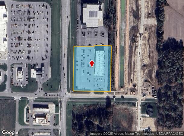
Property Record
1813 Nagel Rd, Avon, OH 44011
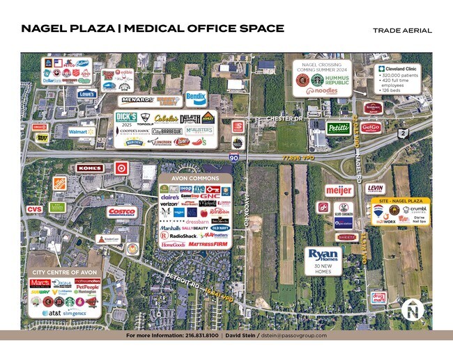
NEARBY LISTINGS FOR SALE OR LEASE
Property Detail
1813 Nagel Rd
Regionalshoppingcenterormallwithanchorstore
Lorain
X
Ohio
39035C0128E
3.70 AC
2024
Lorain County
2024
Cleveland
013101
Cleveland-Elyria, OH
20,080 SF
04-00-027-101-197
DEMOGRAPHICS near 1813 Nagel Rd
1 Mile
3 Mile
5 Mile
2024 Total Population
1,862
47,902
128,447
2029 Population
1,952
48,434
129,669
Pop Growth 2024-2029
+ 4.83%
+ 1.11%
+ 0.95%
Average Age
47
43
43
2024 Total Households
781
18,705
50,788
HH Growth 2024-2029
+ 4.99%
+ 0.94%
+ 0.82%
Median Household Inc
$99,492
$110,706
$96,714
Avg Household Size
2.30
2.50
2.50
2024 Avg HH Vehicles
2.00
2.00
2.00
Median Home Value
$317,574
$350,081
$272,564
Median Year Built
2004
1992
1981
Nearby Places
- Restaurants
- Banks
- Shops
- Fitness
- Groceries
SALE & LEASE HISTORY
LISTING DATE
SALE/LEASE

Dec 29, 2016
For Lease
Nearby Properties
Address
Land Use
TOTAL SIZE
Lot Size
Zoning
Address
Land Use
TOTAL SIZE
Lot Size
Zoning
1,239,072 SF
26.47 AC
PUD
Address
Land Use
TOTAL SIZE
Lot Size
Zoning
634,322 SF
82.83 AC
Address
Land Use
TOTAL SIZE
Lot Size
Zoning
602,400 SF
5.04 AC
PUD
Address
Land Use
TOTAL SIZE
Lot Size
Zoning
221,566 SF
26.09 AC
Address
Land Use
TOTAL SIZE
Lot Size
Zoning
321,868 SF
71.81 AC
Address
Land Use
TOTAL SIZE
Lot Size
Zoning
115,677 SF
33.09 AC
EI
Address
Land Use
TOTAL SIZE
Lot Size
Zoning
156,541 SF
31.07 AC
Address
Land Use
TOTAL SIZE
Lot Size
Zoning
126,640 SF
93.63 AC
Address
Land Use
TOTAL SIZE
Lot Size
Zoning
264,435 SF
25.85 AC
SC
Address
Land Use
TOTAL SIZE
Lot Size
Zoning
148,688 SF
17.15 AC
Address
Land Use
TOTAL SIZE
Lot Size
Zoning
116,942 SF
37.28 AC
Address
Land Use
TOTAL SIZE
Lot Size
Zoning
45,810 SF
36.64 AC
EI
Address
Land Use
TOTAL SIZE
Lot Size
Zoning
553,692 SF
80.04 AC
Address
Land Use
TOTAL SIZE
Lot Size
Zoning
116,057 SF
22.35 AC
Address
Land Use
TOTAL SIZE
Lot Size
Zoning
193,858 SF
19.65 AC
R-MF24
Address
Land Use
TOTAL SIZE
Lot Size
Zoning
194,392 SF
11.18 AC
Address
Land Use
TOTAL SIZE
Lot Size
Zoning
17,121 SF
19.06 AC
R-MF24
Address
Land Use
TOTAL SIZE
Lot Size
Zoning
244,016 SF
26.43 AC
Address
Land Use
TOTAL SIZE
Lot Size
Zoning
42,142 SF
5.37 AC
Address
Land Use
TOTAL SIZE
Lot Size
Zoning
70,474 SF
38.47 AC
Address
Land Use
TOTAL SIZE
Lot Size
Zoning
153,082 SF
13.93 AC
R-MF24
Address
Land Use
TOTAL SIZE
Lot Size
Zoning
163,038 SF
21.16 AC
Address
Land Use
TOTAL SIZE
Lot Size
Zoning
194,868 SF
23.21 AC
Address
Land Use
TOTAL SIZE
Lot Size
Zoning
251,049 SF
13.95 AC
R-MF24
Address
Land Use
TOTAL SIZE
Lot Size
Zoning
34,908 SF
21.46 AC
Address
Land Use
TOTAL SIZE
Lot Size
Zoning
58,594 SF
12.67 AC
Address
Land Use
TOTAL SIZE
Lot Size
Zoning
67,590 SF
23.66 AC
Address
Land Use
TOTAL SIZE
Lot Size
Zoning
184,174 SF
24.39 AC
RB
Address
Land Use
TOTAL SIZE
Lot Size
Zoning
63,135 SF
9.85 AC
Address
Land Use
TOTAL SIZE
Lot Size
Zoning
111,856 SF
0.99 AC
The World's #1 Commercial Real Estate Marketplace
Connect with us
© 2025 CoStar Group
The information above has been obtained from sources believed reliable. While we do not doubt its accuracy we have not verified it and make no guarantee, warranty or representation about it. It is your responsibility to independently confirm its accuracy and completeness. Any projections, opinions, assumptions, or estimates used are for example only and do not represent the current or future performance of the property. The value of this transaction to you depends on tax and other factors which should be evaluated by your tax, financial, and legal advisors. You and your advisors should conduct a careful, independent investigation of the property to determine to your satisfaction the suitability of the property for your needs.