Property Record
1901 S M 291 Hwy, Independence, MO 64057

NEARBY LISTINGS FOR SALE OR LEASE
Property Detail
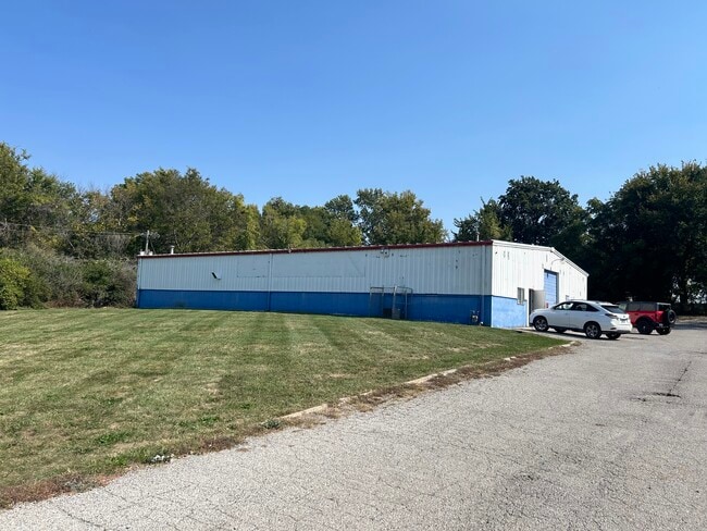
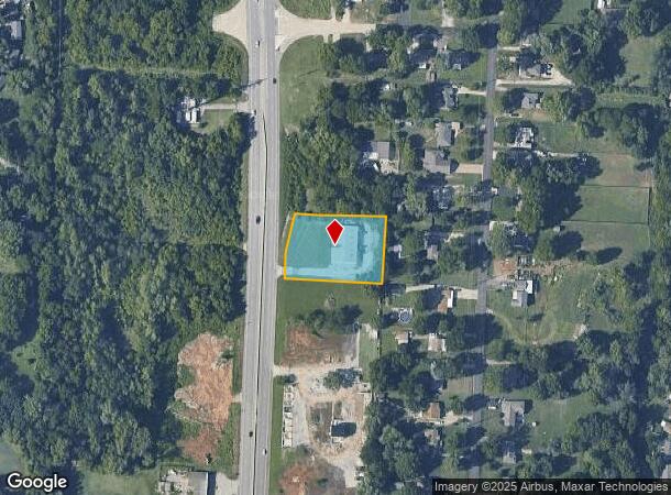
1901 S M 291 Hwy
Kansas City, MO-KS
Stayton Place
25-420-02-42-00-0-00-000
STAYTON PLACE W 270.8 OF LOT 43 (EX PT IN ROW)
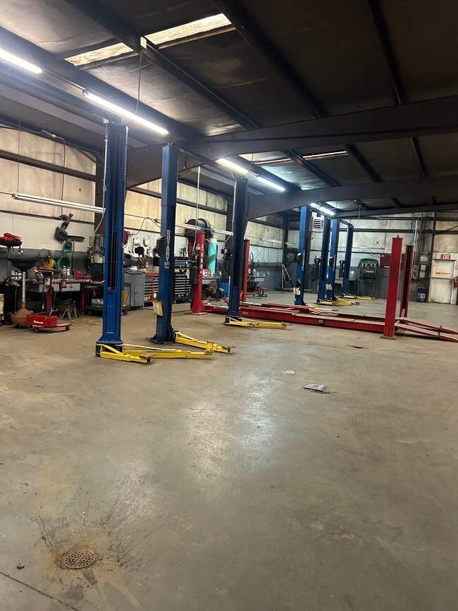
Autorepair
Jackson
X
Missouri
29095C0284G
43
2024
1.15 AC
2025
East Jackson County
014702
Kansas City
7,000 SF
DEMOGRAPHICS near 1901 S M 291 Hwy
1 Mile
3 Mile
5 Mile
2024 Total Population
6,184
59,790
135,164
2029 Population
6,139
59,078
133,938
Pop Growth 2024-2029
(0.73%)
(1.19%)
(0.91%)
Average Age
43
41
41
2024 Total Households
2,686
24,751
55,493
HH Growth 2024-2029
(1.04%)
(1.34%)
(1.02%)
Median Household Inc
$49,749
$58,927
$59,789
Avg Household Size
2.20
2.30
2.30
2024 Avg HH Vehicles
2.00
2.00
2.00
Median Home Value
$166,324
$168,281
$165,895
Median Year Built
1974
1969
1969
Nearby Places
Map Layers
Map Styles
 Street
 Aerial
- Restaurants
- Banks
- Shops
- Fitness
- Groceries
PUBLIC TRANSPORTATION
COMMUTER RAIL
DRIVE
WALK
Distance
9 min
4.2 mi
AIRPORT
Kansas City International
DRIVE
WALK
Distance
Kansas City International
44 min
31.0 mi
SALE & LEASE HISTORY
LISTING DATE
SALE/LEASE

Oct 14, 2024
For Sale
Nearby Properties
Address
Land Use
TOTAL SIZE
Lot Size
Zoning
Address
Land Use
TOTAL SIZE
Lot Size
Zoning
398,212 SF
73.80 AC
Address
Land Use
TOTAL SIZE
Lot Size
Zoning
519,315 SF
28.47 AC
Address
Land Use
TOTAL SIZE
Lot Size
Zoning
100,724 SF
1.65 AC
Address
Land Use
TOTAL SIZE
Lot Size
Zoning
250,196 SF
39.50 AC
Address
Land Use
TOTAL SIZE
Lot Size
Zoning
455,100 SF
42.02 AC
Address
Land Use
TOTAL SIZE
Lot Size
Zoning
385,487 SF
5.61 AC
Address
Land Use
TOTAL SIZE
Lot Size
Zoning
338,731 SF
29.59 AC
Address
Land Use
TOTAL SIZE
Lot Size
Zoning
123,305 SF
15.51 AC
Address
Land Use
TOTAL SIZE
Lot Size
Zoning
64,318 SF
32.40 AC
Address
Land Use
TOTAL SIZE
Lot Size
Zoning
Address
Land Use
TOTAL SIZE
Lot Size
Zoning
287,132 SF
Address
Land Use
TOTAL SIZE
Lot Size
Zoning
193,191 SF
4.14 AC
Address
Land Use
TOTAL SIZE
Lot Size
Zoning
286,547 SF
Address
Land Use
TOTAL SIZE
Lot Size
Zoning
178,652 SF
15.07 AC
Address
Land Use
TOTAL SIZE
Lot Size
Zoning
157,666 SF
18.54 AC
Address
Land Use
TOTAL SIZE
Lot Size
Zoning
68,921 SF
18.04 AC
Address
Land Use
TOTAL SIZE
Lot Size
Zoning
157,429 SF
36.60 AC
Address
Land Use
TOTAL SIZE
Lot Size
Zoning
56,664 SF
Address
Land Use
TOTAL SIZE
Lot Size
Zoning
111,445 SF
8 AC
Address
Land Use
TOTAL SIZE
Lot Size
Zoning
137,992 SF
12.50 AC
Address
Land Use
TOTAL SIZE
Lot Size
Zoning
48,664 SF
8.44 AC
Address
Land Use
TOTAL SIZE
Lot Size
Zoning
113,667 SF
6.31 AC
Address
Land Use
TOTAL SIZE
Lot Size
Zoning
190,810 SF
26.90 AC
Address
Land Use
TOTAL SIZE
Lot Size
Zoning
36,883 SF
14.60 AC
Address
Land Use
TOTAL SIZE
Lot Size
Zoning
286,490 SF
37.30 AC
Address
Land Use
TOTAL SIZE
Lot Size
Zoning
24,225 SF
Address
Land Use
TOTAL SIZE
Lot Size
Zoning
66,168 SF
44.98 AC
Address
Land Use
TOTAL SIZE
Lot Size
Zoning
45,870 SF
2.01 AC
Address
Land Use
TOTAL SIZE
Lot Size
Zoning
30,630 SF
14.08 AC
Address
Land Use
TOTAL SIZE
Lot Size
Zoning
104,740 SF
7.25 AC
The World's #1 Commercial Real Estate Marketplace
Connect with us
© 2025 CoStar Group
The information above has been obtained from sources believed reliable. While we do not doubt its accuracy we have not verified it and make no guarantee, warranty or representation about it. It is your responsibility to independently confirm its accuracy and completeness. Any projections, opinions, assumptions, or estimates used are for example only and do not represent the current or future performance of the property. The value of this transaction to you depends on tax and other factors which should be evaluated by your tax, financial, and legal advisors. You and your advisors should conduct a careful, independent investigation of the property to determine to your satisfaction the suitability of the property for your needs.