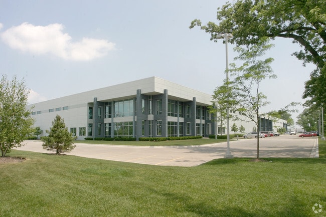
Property Record
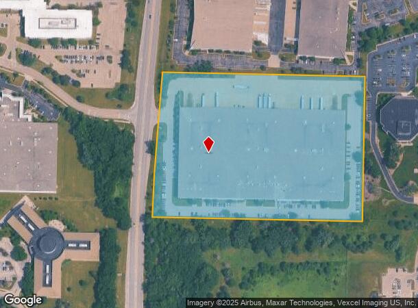
1901 S Waukegan Rd, Waukegan, IL 60085
NEARBY LISTINGS FOR SALE OR LEASE
Property Detail
1901 S Waukegan Rd
Chicago-Naperville-Elgin, IL-IN-WI
Amhurst Industrial V-Vi Resub
11-01-201-075
AMHURST INDUSTRIAL V-VI RESUB;LOT 300
Industrialgeneral
Lake
X
Illinois
17097C0159K
300
2023
12.33 AC
2024
North Lake County
863601
Chicago
DEMOGRAPHICS near 1901 S Waukegan Rd
1 Mile
3 Mile
5 Mile
2024 Total Population
1,565
58,397
155,437
2029 Population
1,545
57,553
152,963
Pop Growth 2024-2029
(1.28%)
(1.45%)
(1.59%)
Average Age
35
36
37
2024 Total Households
620
19,982
52,990
HH Growth 2024-2029
(1.45%)
(1.47%)
(1.64%)
Median Household Inc
$85,416
$64,644
$72,247
Avg Household Size
2.50
2.80
2.70
2024 Avg HH Vehicles
2.00
2.00
2.00
Median Home Value
$499,999
$191,340
$259,842
Median Year Built
1990
1977
1974
Nearby Places
- Restaurants
- Banks
- Shops
- Fitness
- Groceries
PUBLIC TRANSPORTATION
COMMUTER RAIL
Great Lakes Station (Union Pacific North Line - Northeast Illinois Regional Commuter Railroad (Metra))
DRIVE
WALK
Distance
Great Lakes Station (Union Pacific North Line - Northeast Illinois Regional Commuter Railroad (Metra))
6 min
3.6 mi
North Chicago Station (Union Pacific North Line - Northeast Illinois Regional Commuter Railroad (Metra))
DRIVE
WALK
Distance
North Chicago Station (Union Pacific North Line - Northeast Illinois Regional Commuter Railroad (Metra))
8 min
5.2 mi
AIRPORT
Chicago O'Hare International
DRIVE
WALK
Distance
Chicago O'Hare International
37 min
27.9 mi
Freight Ports
Port Milwaukee
DRIVE
WALK
Distance
Port Milwaukee
60 min
49.9 mi
Nearby Properties
Address
Land Use
TOTAL SIZE
Lot Size
Zoning
Address
Land Use
TOTAL SIZE
Lot Size
Zoning
182.08 AC
Address
Land Use
TOTAL SIZE
Lot Size
Zoning
74.05 AC
Address
Land Use
TOTAL SIZE
Lot Size
Zoning
296.29 AC
Address
Land Use
TOTAL SIZE
Lot Size
Zoning
13.85 AC
Address
Land Use
TOTAL SIZE
Lot Size
Zoning
29.84 AC
Address
Land Use
TOTAL SIZE
Lot Size
Zoning
Address
Land Use
TOTAL SIZE
Lot Size
Zoning
545,716 SF
31.05 AC
Address
Land Use
TOTAL SIZE
Lot Size
Zoning
625,928 SF
32.17 AC
Address
Land Use
TOTAL SIZE
Lot Size
Zoning
500,160 SF
28.37 AC
Address
Land Use
TOTAL SIZE
Lot Size
Zoning
4,116,168 SF
17.20 AC
Address
Land Use
TOTAL SIZE
Lot Size
Zoning
12.45 AC
Address
Land Use
TOTAL SIZE
Lot Size
Zoning
66.57 AC
Address
Land Use
TOTAL SIZE
Lot Size
Zoning
763,840 SF
19.85 AC
Address
Land Use
TOTAL SIZE
Lot Size
Zoning
14.03 AC
Address
Land Use
TOTAL SIZE
Lot Size
Zoning
401,949 SF
20.18 AC
Address
Land Use
TOTAL SIZE
Lot Size
Zoning
306,160 SF
15.43 AC
Address
Land Use
TOTAL SIZE
Lot Size
Zoning
Address
Land Use
TOTAL SIZE
Lot Size
Zoning
225,626 SF
4.11 AC
Address
Land Use
TOTAL SIZE
Lot Size
Zoning
91,058 SF
30.15 AC
Address
Land Use
TOTAL SIZE
Lot Size
Zoning
329,752 SF
15.60 AC
Address
Land Use
TOTAL SIZE
Lot Size
Zoning
2,155,686 SF
7.97 AC
Address
Land Use
TOTAL SIZE
Lot Size
Zoning
14.49 AC
Address
Land Use
TOTAL SIZE
Lot Size
Zoning
1,082,769 SF
31.84 AC
Address
Land Use
TOTAL SIZE
Lot Size
Zoning
362,809 SF
21.48 AC
Address
Land Use
TOTAL SIZE
Lot Size
Zoning
394,910 SF
20.13 AC
Address
Land Use
TOTAL SIZE
Lot Size
Zoning
1,915,680 SF
8.37 AC
Address
Land Use
TOTAL SIZE
Lot Size
Zoning
3,901,972 SF
15.66 AC
Address
Land Use
TOTAL SIZE
Lot Size
Zoning
2,939,829 SF
15.73 AC
Address
Land Use
TOTAL SIZE
Lot Size
Zoning
4,292,796 SF
16.39 AC
Address
Land Use
TOTAL SIZE
Lot Size
Zoning
1,632,262 SF
12.98 AC
The World's #1 Commercial Real Estate Marketplace
Connect with us
© 2025 CoStar Group
The information above has been obtained from sources believed reliable. While we do not doubt its accuracy we have not verified it and make no guarantee, warranty or representation about it. It is your responsibility to independently confirm its accuracy and completeness. Any projections, opinions, assumptions, or estimates used are for example only and do not represent the current or future performance of the property. The value of this transaction to you depends on tax and other factors which should be evaluated by your tax, financial, and legal advisors. You and your advisors should conduct a careful, independent investigation of the property to determine to your satisfaction the suitability of the property for your needs.