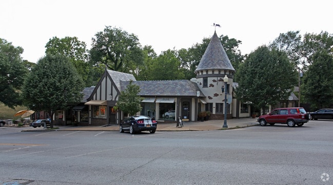
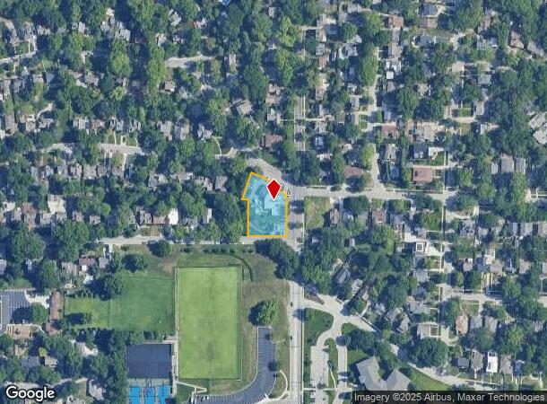
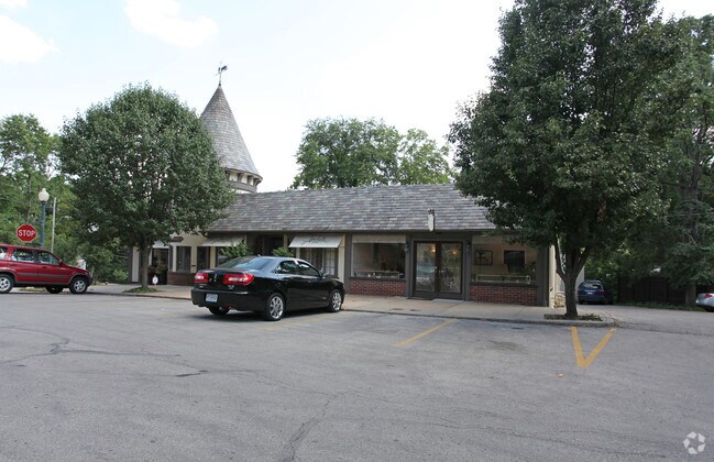
Property Record
1901 W 50Th St, Mission, KS 66205
NEARBY LISTINGS FOR SALE OR LEASE
Property Detail
1901 W 50Th St
Kansas City, MO-KS
Westwood Hills
SP10000005-0043
WESTWOOD HILLS LT 43 44 45 & 46 BLK 5 & LT 2 BLK 5 EX WLY TR 70.75 ON N & 45.67 ON S WHC 249
Regionalshoppingcenterormallwithanchorstore
Johnson
X
Kansas
29095C0261G
43
2024
0.56 AC
2024
Northeast Johnson County
050100
Kansas City
6,166 SF
DEMOGRAPHICS near 1901 W 50Th St
1 Mile
3 Mile
5 Mile
2024 Total Population
14,484
119,677
282,288
2029 Population
14,653
121,276
286,771
Pop Growth 2024-2029
+ 1.17%
+ 1.34%
+ 1.59%
Average Age
40
39
39
2024 Total Households
7,880
57,358
129,197
HH Growth 2024-2029
+ 1.07%
+ 1.39%
+ 1.68%
Median Household Inc
$92,374
$71,583
$63,294
Avg Household Size
1.80
2.00
2.10
2024 Avg HH Vehicles
2.00
2.00
2.00
Median Home Value
$401,478
$312,163
$248,474
Median Year Built
1949
1950
1954
Nearby Places
Map Layers
Map Styles
 Street
 Aerial
- Restaurants
- Banks
- Shops
- Fitness
- Groceries
PUBLIC TRANSPORTATION
COMMUTER RAIL
DRIVE
WALK
Distance
11 min
4.4 mi
AIRPORT
Kansas City International
DRIVE
WALK
Distance
Kansas City International
36 min
23.2 mi
Nearby Properties
Address
Land Use
TOTAL SIZE
Lot Size
Zoning
Address
Land Use
TOTAL SIZE
Lot Size
Zoning
761,113 SF
18.37 AC
KC3
Address
Land Use
TOTAL SIZE
Lot Size
Zoning
91,485 SF
10.11 AC
Address
Land Use
TOTAL SIZE
Lot Size
Zoning
208,800 SF
5.57 AC
KRP5
Address
Land Use
TOTAL SIZE
Lot Size
Zoning
191,956 SF
10.45 AC
KR1B
Address
Land Use
TOTAL SIZE
Lot Size
Zoning
711,196 SF
15.58 AC
Address
Land Use
TOTAL SIZE
Lot Size
Zoning
105,247 SF
0.72 AC
Address
Land Use
TOTAL SIZE
Lot Size
Zoning
543,241 SF
8.39 AC
Address
Land Use
TOTAL SIZE
Lot Size
Zoning
626,244 SF
16.41 AC
Address
Land Use
TOTAL SIZE
Lot Size
Zoning
124,492 SF
4.24 AC
Address
Land Use
TOTAL SIZE
Lot Size
Zoning
212,475 SF
30.20 AC
PUB
Address
Land Use
TOTAL SIZE
Lot Size
Zoning
69,130 SF
6.49 AC
R-1
Address
Land Use
TOTAL SIZE
Lot Size
Zoning
129,265 SF
1.17 AC
Address
Land Use
TOTAL SIZE
Lot Size
Zoning
109,563 SF
0.98 AC
Address
Land Use
TOTAL SIZE
Lot Size
Zoning
149,157 SF
0.02 AC
URD
Address
Land Use
TOTAL SIZE
Lot Size
Zoning
251,409 SF
3.39 AC
Address
Land Use
TOTAL SIZE
Lot Size
Zoning
42,597 SF
4.39 AC
MS2
Address
Land Use
TOTAL SIZE
Lot Size
Zoning
90,774 SF
1.73 AC
MS2
Address
Land Use
TOTAL SIZE
Lot Size
Zoning
379,472 SF
Address
Land Use
TOTAL SIZE
Lot Size
Zoning
168,438 SF
3.13 AC
C-O
Address
Land Use
TOTAL SIZE
Lot Size
Zoning
99,812 SF
3.85 AC
R-1A
Address
Land Use
TOTAL SIZE
Lot Size
Zoning
369,624 SF
7.50 AC
Address
Land Use
TOTAL SIZE
Lot Size
Zoning
64,964 SF
0.85 AC
Address
Land Use
TOTAL SIZE
Lot Size
Zoning
124,249 SF
6.13 AC
R-1B
Address
Land Use
TOTAL SIZE
Lot Size
Zoning
193,643 SF
20.63 AC
Address
Land Use
TOTAL SIZE
Lot Size
Zoning
70,449 SF
0.66 AC
Address
Land Use
TOTAL SIZE
Lot Size
Zoning
106,648 SF
16.93 AC
R-1A
Address
Land Use
TOTAL SIZE
Lot Size
Zoning
68,134 SF
5.24 AC
C-O
Address
Land Use
TOTAL SIZE
Lot Size
Zoning
309,426 SF
21.62 AC
Address
Land Use
TOTAL SIZE
Lot Size
Zoning
174,983 SF
10.43 AC
Address
Land Use
TOTAL SIZE
Lot Size
Zoning
66,340 SF
14.92 AC
KRP5
The World's #1 Commercial Real Estate Marketplace
Connect with us
© 2026 CoStar Group
The information above has been obtained from sources believed reliable. While we do not doubt its accuracy we have not verified it and make no guarantee, warranty or representation about it. It is your responsibility to independently confirm its accuracy and completeness. Any projections, opinions, assumptions, or estimates used are for example only and do not represent the current or future performance of the property. The value of this transaction to you depends on tax and other factors which should be evaluated by your tax, financial, and legal advisors. You and your advisors should conduct a careful, independent investigation of the property to determine to your satisfaction the suitability of the property for your needs.