Property Record
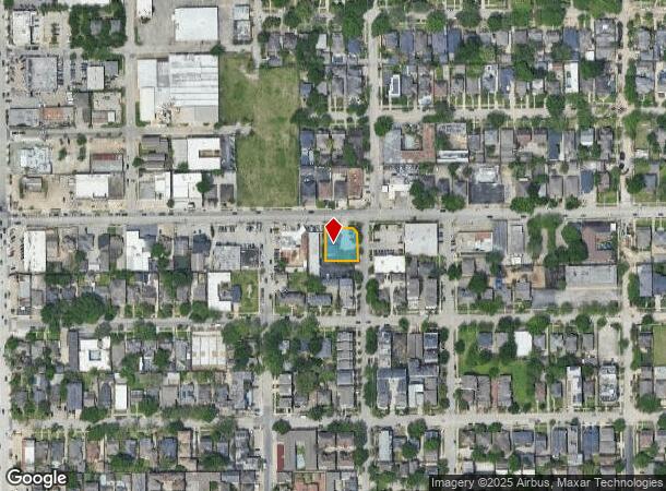
1901 W Alabama St, Houston, TX 77098
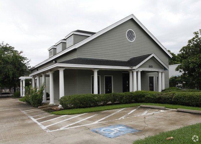

This Property Is For Sale
NEARBY LISTINGS FOR SALE OR LEASE
Property Detail
1901 W Alabama St
Houston-The Woodlands-Sugar Land, TX
Montlew Place
0382140000004
LT 4 & TR 5 BLK 1 MONTLEW PLACE
Storebuilding
Harris
X
Texas
48201C0860L
4
2024
0.23 AC
2025
Inner Loop River Oaks
410801
Houston
2,332 SF
DEMOGRAPHICS near 1901 W Alabama St
1 Mile
3 Mile
5 Mile
2024 Total Population
31,929
222,245
541,690
2029 Population
33,145
231,813
563,632
Pop Growth 2024-2029
+ 3.81%
+ 4.31%
+ 4.05%
Average Age
40
38
38
2024 Total Households
17,463
116,695
256,569
HH Growth 2024-2029
+ 3.85%
+ 4.43%
+ 4.23%
Median Household Inc
$109,889
$102,700
$85,902
Avg Household Size
1.80
1.80
2.00
2024 Avg HH Vehicles
2.00
2.00
2.00
Median Home Value
$729,606
$601,051
$491,555
Median Year Built
1992
2002
1996
Nearby Places
- Restaurants
- Banks
- Shops
- Fitness
- Groceries
PUBLIC TRANSPORTATION
COMMUTER RAIL
Houston (Sunset Limited - Amtrak)
DRIVE
WALK
Distance
Houston (Sunset Limited - Amtrak)
9 min
4.9 mi
AIRPORT
William P Hobby
DRIVE
WALK
Distance
William P Hobby
27 min
15.1 mi
George Bush Intcntl/Houston
DRIVE
WALK
Distance
George Bush Intcntl/Houston
32 min
23.8 mi
Freight Ports
Port of Houston
DRIVE
WALK
Distance
Port of Houston
24 min
14.4 mi
Nearby Properties
Address
Land Use
TOTAL SIZE
Lot Size
Zoning
Address
Land Use
TOTAL SIZE
Lot Size
Zoning
973,861 SF
1.18 AC
Address
Land Use
TOTAL SIZE
Lot Size
Zoning
797,208 SF
1.46 AC
Address
Land Use
TOTAL SIZE
Lot Size
Zoning
519,409 SF
1.52 AC
Address
Land Use
TOTAL SIZE
Lot Size
Zoning
1,871,418 SF
1.44 AC
Address
Land Use
TOTAL SIZE
Lot Size
Zoning
1,252,274 SF
2.02 AC
Address
Land Use
TOTAL SIZE
Lot Size
Zoning
716,631 SF
7.04 AC
Address
Land Use
TOTAL SIZE
Lot Size
Zoning
1,880,742 SF
20.77 AC
Address
Land Use
TOTAL SIZE
Lot Size
Zoning
1,232,364 SF
1.49 AC
Address
Land Use
TOTAL SIZE
Lot Size
Zoning
1,436,400 SF
1.44 AC
Address
Land Use
TOTAL SIZE
Lot Size
Zoning
1,321,033 SF
1.46 AC
Address
Land Use
TOTAL SIZE
Lot Size
Zoning
4,169,721 SF
31.23 AC
Address
Land Use
TOTAL SIZE
Lot Size
Zoning
2,005,097 SF
1.44 AC
Address
Land Use
TOTAL SIZE
Lot Size
Zoning
1,374,271 SF
1.44 AC
Address
Land Use
TOTAL SIZE
Lot Size
Zoning
1,150,681 SF
1.17 AC
Address
Land Use
TOTAL SIZE
Lot Size
Zoning
515,025 SF
1.50 AC
Address
Land Use
TOTAL SIZE
Lot Size
Zoning
704,249 SF
2.34 AC
Address
Land Use
TOTAL SIZE
Lot Size
Zoning
1,657,484 SF
1.44 AC
Address
Land Use
TOTAL SIZE
Lot Size
Zoning
1,282,908 SF
2.74 AC
Address
Land Use
TOTAL SIZE
Lot Size
Zoning
1,311,133 SF
1.44 AC
Address
Land Use
TOTAL SIZE
Lot Size
Zoning
555,351 SF
1.40 AC
Address
Land Use
TOTAL SIZE
Lot Size
Zoning
1,181,384 SF
1.47 AC
Address
Land Use
TOTAL SIZE
Lot Size
Zoning
1,044,305 SF
3.16 AC
Address
Land Use
TOTAL SIZE
Lot Size
Zoning
1,162,204 SF
1.44 AC
Address
Land Use
TOTAL SIZE
Lot Size
Zoning
1,103,424 SF
1.44 AC
Address
Land Use
TOTAL SIZE
Lot Size
Zoning
1,359,194 SF
Address
Land Use
TOTAL SIZE
Lot Size
Zoning
1,365,801 SF
1.44 AC
Address
Land Use
TOTAL SIZE
Lot Size
Zoning
565,276 SF
1.35 AC
Address
Land Use
TOTAL SIZE
Lot Size
Zoning
644,352 SF
8.05 AC
Address
Land Use
TOTAL SIZE
Lot Size
Zoning
1,017,783 SF
1.44 AC
Address
Land Use
TOTAL SIZE
Lot Size
Zoning
608,233 SF
2.23 AC
The World's #1 Commercial Real Estate Marketplace
Connect with us
© 2025 CoStar Group
The information above has been obtained from sources believed reliable. While we do not doubt its accuracy we have not verified it and make no guarantee, warranty or representation about it. It is your responsibility to independently confirm its accuracy and completeness. Any projections, opinions, assumptions, or estimates used are for example only and do not represent the current or future performance of the property. The value of this transaction to you depends on tax and other factors which should be evaluated by your tax, financial, and legal advisors. You and your advisors should conduct a careful, independent investigation of the property to determine to your satisfaction the suitability of the property for your needs.