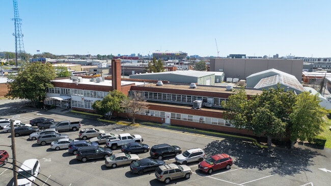
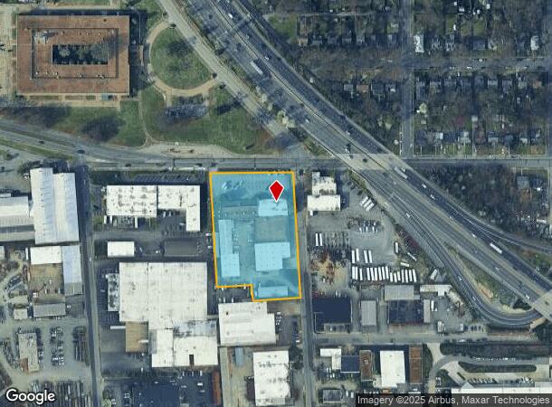
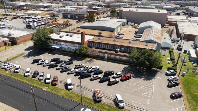
Property Record
1901 Westwood Ave, Richmond, VA 23227

This Property Is For Sale
NEARBY LISTINGS FOR SALE OR LEASE
Property Detail
1901 Westwood Ave
N000-1875-021
0286.97X0432.19 IRG0002.709 AC
Clubslodgesprofessionalassociations
Richmond City
X
Virginia
5101290029E
2.71 AC
2025
Scott's Add/West End
2025
Richmond VA
040202
Richmond, VA
37,882 SF
DEMOGRAPHICS near 1901 Westwood Ave
1 Mile
3 Mile
5 Mile
2024 Total Population
9,277
124,632
261,837
2029 Population
9,683
127,942
268,353
Pop Growth 2024-2029
+ 4.38%
+ 2.66%
+ 2.49%
Average Age
45
38
39
2024 Total Households
5,391
57,450
118,884
HH Growth 2024-2029
+ 4.54%
+ 2.66%
+ 2.62%
Median Household Inc
$58,451
$58,698
$60,188
Avg Household Size
1.60
2.00
2.00
2024 Avg HH Vehicles
1.00
1.00
2.00
Median Home Value
$372,450
$339,134
$301,989
Median Year Built
1962
1952
1959
Nearby Places
- Restaurants
- Banks
- Shops
- Fitness
- Groceries
PUBLIC TRANSPORTATION
COMMUTER RAIL
Richmond Staples Mill Road Amtrak Station (Carolinian - Amtrak, Northeast Regional - Amtrak, Palmetto - Amtrak, Silver Meteor - Amtrak)
DRIVE
WALK
Distance
Richmond Staples Mill Road Amtrak Station (Carolinian - Amtrak, Northeast Regional - Amtrak, Palmetto - Amtrak, Silver Meteor - Amtrak)
8 min
4.3 mi
Richmond Main Street Amtrak Station (Northeast Regional - Amtrak)
DRIVE
WALK
Distance
Richmond Main Street Amtrak Station (Northeast Regional - Amtrak)
7 min
4.5 mi
AIRPORT
Richmond International
DRIVE
WALK
Distance
Richmond International
20 min
12.4 mi
Freight Ports
Virginia Port Authority - Richmond
DRIVE
WALK
Distance
Virginia Port Authority - Richmond
18 min
10.7 mi
Nearby Properties
Address
Land Use
TOTAL SIZE
Lot Size
Zoning
Address
Land Use
TOTAL SIZE
Lot Size
Zoning
494,791 SF
38.85 AC
R-6
Address
Land Use
TOTAL SIZE
Lot Size
Zoning
450,000 SF
4.35 AC
RP REASEAR
Address
Land Use
TOTAL SIZE
Lot Size
Zoning
272,131 SF
11.22 AC
R-6 SINGLE
Address
Land Use
TOTAL SIZE
Lot Size
Zoning
226,734 SF
3.67 AC
B-3 GENERA
Address
Land Use
TOTAL SIZE
Lot Size
Zoning
1,728 SF
2.99 AC
MULTIPLE Z
Address
Land Use
TOTAL SIZE
Lot Size
Zoning
482,958 SF
2.38 AC
M-1 LIGHT
Address
Land Use
TOTAL SIZE
Lot Size
Zoning
1,185 SF
2.54 AC
M-1 LIGHT
Address
Land Use
TOTAL SIZE
Lot Size
Zoning
382,570 SF
2.98 AC
UMUC
Address
Land Use
TOTAL SIZE
Lot Size
Zoning
14.89 AC
R-53 MULTI
Address
Land Use
TOTAL SIZE
Lot Size
Zoning
111,948 SF
2.64 AC
RP REASEAR
Address
Land Use
TOTAL SIZE
Lot Size
Zoning
185,604 SF
2.30 AC
MULTIPLE Z
Address
Land Use
TOTAL SIZE
Lot Size
Zoning
16.14 AC
MULTIPLE Z
Address
Land Use
TOTAL SIZE
Lot Size
Zoning
111,876 SF
5.90 AC
M-1 LIGHT
Address
Land Use
TOTAL SIZE
Lot Size
Zoning
321,552 SF
UMUC
Address
Land Use
TOTAL SIZE
Lot Size
Zoning
2.11 AC
M-1
Address
Land Use
TOTAL SIZE
Lot Size
Zoning
299,820 SF
3.16 AC
M-2 HEAVY
Address
Land Use
TOTAL SIZE
Lot Size
Zoning
80,519 SF
27.21 AC
I INSTITUT
Address
Land Use
TOTAL SIZE
Lot Size
Zoning
319,512 SF
20.33 AC
UMU
Address
Land Use
TOTAL SIZE
Lot Size
Zoning
379,598 SF
11.11 AC
DCC-DOWNTO
Address
Land Use
TOTAL SIZE
Lot Size
Zoning
179,870 SF
7.36 AC
MULTIPLE Z
Address
Land Use
TOTAL SIZE
Lot Size
Zoning
250,000 SF
4.04 AC
Address
Land Use
TOTAL SIZE
Lot Size
Zoning
97,713 SF
21.60 AC
B-4 CENTRA
Address
Land Use
TOTAL SIZE
Lot Size
Zoning
2,909 SF
2.47 AC
M-1 LIGHT
Address
Land Use
TOTAL SIZE
Lot Size
Zoning
21,954 SF
4.79 AC
B-3 GENERA
Address
Land Use
TOTAL SIZE
Lot Size
Zoning
1,404 SF
30.52 AC
R-5
Address
Land Use
TOTAL SIZE
Lot Size
Zoning
3.25 AC
M-1 LIGHT
Address
Land Use
TOTAL SIZE
Lot Size
Zoning
395,435 SF
13.26 AC
O-3C
Address
Land Use
TOTAL SIZE
Lot Size
Zoning
126,303 SF
4.50 AC
M-1 LIGHT
Address
Land Use
TOTAL SIZE
Lot Size
Zoning
125,517 SF
1.44 AC
R-73 MULTI
Address
Land Use
TOTAL SIZE
Lot Size
Zoning
59,574 SF
313.03 AC
MIXE
The World's #1 Commercial Real Estate Marketplace
Connect with us
© 2025 CoStar Group
The information above has been obtained from sources believed reliable. While we do not doubt its accuracy we have not verified it and make no guarantee, warranty or representation about it. It is your responsibility to independently confirm its accuracy and completeness. Any projections, opinions, assumptions, or estimates used are for example only and do not represent the current or future performance of the property. The value of this transaction to you depends on tax and other factors which should be evaluated by your tax, financial, and legal advisors. You and your advisors should conduct a careful, independent investigation of the property to determine to your satisfaction the suitability of the property for your needs.