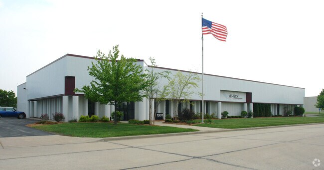
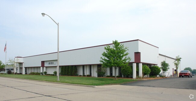
Property Record
1901 William St, Racine, WI 53404

Save to a Folder
{{folder.Name}}
{{folder.ListingIds.length}} Properties
{{folder.ListingIds.length}} Property
Create a New Folder
Property Detail
1901 William St
Racine-Mount Pleasant, WI
FRED M YOUNG INDUSTRIAL PARK N 230 FT OF WLY 83.11 FT LOT 13 + E 180.31 FT LOT 14 1.390 AC MOL
276-000020936015
Racine
Commercialnec
Wisconsin
I2
13
B and X Area of moderate flood hazard, usually the area between the limits of the 100-year and 500-year floods.
1.39 AC
2025
Racine East
2025
Milwaukee/Madison
001201
NEARBY LISTINGS FOR SALE OR LEASE
DEMOGRAPHICS near 1901 William St
1 mile
3 mile
5 mile
2025 Total Population
14,756
74,587
122,331
2030 Population
14,859
75,190
123,194
Pop Growth 2025-2030
+ 0.70%
+ 0.81%
+ 0.71%
Average Age
38
39
40
2025 Total Households
5,926
30,105
49,947
HH Growth 2025-2030
+ 0.71%
+ 0.81%
+ 0.71%
Median Household Inc
$59,978
$63,415
$66,728
Avg Household Size
2.40
2.40
2.40
2025 Avg HH Vehicles
2.00
2.00
2.00
Median Home Value
$163,665
$196,610
$203,271
Median Year Built
1954
1957
1962
Nearby Places
Map Layers
Map Styles
 Street
 Aerial
Layers
 Traffic
 Biking
Places
Listings with unknown addresses are not visible on the map
- Restaurants
- Banks
- Shops
- Fitness
- Groceries
PUBLIC TRANSPORTATION
COMMUTER RAIL
Sturtevant Amtrak Station (Hiawatha Service - Amtrak)
Drive
Walk
Distance
Sturtevant Amtrak Station (Hiawatha Service - Amtrak)
16 min
7.9 mi
AIRPORT
General Mitchell International
Drive
Walk
Distance
General Mitchell International
31 min
17.8 mi
Freight Ports
Port Milwaukee
Drive
Walk
Distance
Port Milwaukee
37 min
23.8 mi
SALE & LEASE HISTORY
LISTING DATE
SALE/LEASE

Oct 06, 2022
For Lease
Nearby Properties
Address
Land Use
TOTAL SIZE
Lot Size
Zoning
Address
Land Use
TOTAL SIZE
Lot Size
Zoning
Address
Land Use
TOTAL SIZE
Lot Size
Zoning
61,744 SF
42.23 AC
OI
Address
Land Use
TOTAL SIZE
Lot Size
Zoning
14.11 AC
I2
Address
Land Use
TOTAL SIZE
Lot Size
Zoning
180,831 SF
1.49 AC
B4
Address
Land Use
TOTAL SIZE
Lot Size
Zoning
24.48 AC
Address
Land Use
TOTAL SIZE
Lot Size
Zoning
9,982 SF
0.39 AC
B4
Address
Land Use
TOTAL SIZE
Lot Size
Zoning
94.35 AC
Address
Land Use
TOTAL SIZE
Lot Size
Zoning
9.18 AC
Address
Land Use
TOTAL SIZE
Lot Size
Zoning
3.54 AC
B4
Address
Land Use
TOTAL SIZE
Lot Size
Zoning
Address
Land Use
TOTAL SIZE
Lot Size
Zoning
Address
Land Use
TOTAL SIZE
Lot Size
Zoning
Address
Land Use
TOTAL SIZE
Lot Size
Zoning
Address
Land Use
TOTAL SIZE
Lot Size
Zoning
Address
Land Use
TOTAL SIZE
Lot Size
Zoning
23.15 AC
I2
Address
Land Use
TOTAL SIZE
Lot Size
Zoning
12.10 AC
I2
Address
Land Use
TOTAL SIZE
Lot Size
Zoning
44,439 SF
1.75 AC
B4
Address
Land Use
TOTAL SIZE
Lot Size
Zoning
10.50 AC
Address
Land Use
TOTAL SIZE
Lot Size
Zoning
91,381 SF
6.62 AC
B2
Address
Land Use
TOTAL SIZE
Lot Size
Zoning
122,640 SF
8.27 AC
R4
Address
Land Use
TOTAL SIZE
Lot Size
Zoning
8.08 AC
Address
Land Use
TOTAL SIZE
Lot Size
Zoning
71,184 SF
1.05 AC
B4
Address
Land Use
TOTAL SIZE
Lot Size
Zoning
78,748 SF
0.88 AC
I2
Address
Land Use
TOTAL SIZE
Lot Size
Zoning
5.53 AC
R4
Address
Land Use
TOTAL SIZE
Lot Size
Zoning
6.77 AC
I2IP
Address
Land Use
TOTAL SIZE
Lot Size
Zoning
Address
Land Use
TOTAL SIZE
Lot Size
Zoning
93,000 SF
3.58 AC
R4
Address
Land Use
TOTAL SIZE
Lot Size
Zoning
95,831 SF
1 AC
B4
Address
Land Use
TOTAL SIZE
Lot Size
Zoning
Address
Land Use
TOTAL SIZE
Lot Size
Zoning
209,664 SF
2.82 AC
B5
The World's #1 Commercial Real Estate Marketplace
Connect with us
© 2026 CoStar Group
The information above has been obtained from sources believed reliable. While we do not doubt its accuracy we have not verified it and make no guarantee, warranty or representation about it. It is your responsibility to independently confirm its accuracy and completeness. Any projections, opinions, assumptions, or estimates used are for example only and do not represent the current or future performance of the property. The value of this transaction to you depends on tax and other factors which should be evaluated by your tax, financial, and legal advisors. You and your advisors should conduct a careful, independent investigation of the property to determine to your satisfaction the suitability of the property for your needs.