Property Record
19012 Ne 139Th St, Brush Prairie, WA 98606
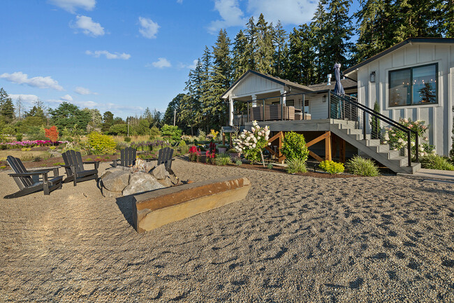
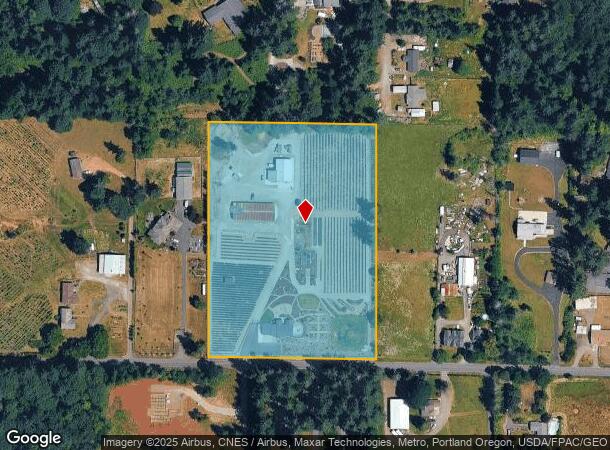
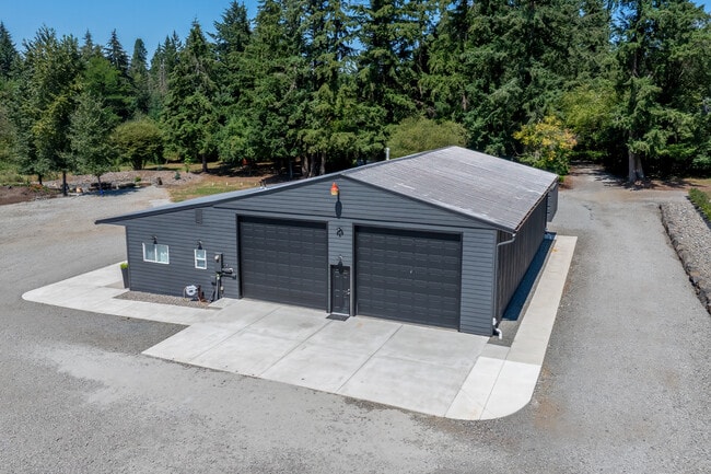
This Property Is For Sale
NEARBY LISTINGS FOR SALE OR LEASE
-
-
View all Brush Prairie listings for sale on LoopNet.com
Property Detail
19012 Ne 139Th St
Portland-Vancouver-Hillsboro, OR-WA
Clark
204476-000
Washington
Sfr
7 AC
X
Clark County Outlying
53011C0401D
Portland
1,433 SF
DEMOGRAPHICS near 19012 Ne 139Th St
1 Mile
3 Mile
5 Mile
2024 Total Population
1,169
14,836
74,615
2029 Population
1,241
15,990
80,318
Pop Growth 2024-2029
+ 6.16%
+ 7.78%
+ 7.64%
Average Age
42
41
39
2024 Total Households
364
4,810
24,936
HH Growth 2024-2029
+ 6.04%
+ 7.80%
+ 7.62%
Median Household Inc
$141,346
$120,220
$96,271
Avg Household Size
3.10
3.00
2.90
2024 Avg HH Vehicles
3.00
3.00
2.00
Median Home Value
$665,948
$621,818
$463,022
Median Year Built
1987
1995
1996
Nearby Places
- Restaurants
- Banks
- Shops
- Fitness
- Groceries
PUBLIC TRANSPORTATION
AIRPORT
Portland International
DRIVE
WALK
Distance
Portland International
28 min
16.7 mi
Freight Ports
Port of Vancouver
DRIVE
WALK
Distance
Port of Vancouver
27 min
15.1 mi
Nearby Properties
Address
Land Use
TOTAL SIZE
Lot Size
Zoning
Address
Land Use
TOTAL SIZE
Lot Size
Zoning
157,245 SF
39 AC
R-5
Address
Land Use
TOTAL SIZE
Lot Size
Zoning
140,352 SF
25.52 AC
RC-1
Address
Land Use
TOTAL SIZE
Lot Size
Zoning
57,214 SF
10.89 AC
R1-6
Address
Land Use
TOTAL SIZE
Lot Size
Zoning
101,587 SF
24.22 AC
R-5
Address
Land Use
TOTAL SIZE
Lot Size
Zoning
36,371 SF
8.25 AC
R-5
Address
Land Use
TOTAL SIZE
Lot Size
Zoning
14,556 SF
5.79 AC
PF
Address
Land Use
TOTAL SIZE
Lot Size
Zoning
5,760 SF
1.11 AC
CR-2
Address
Land Use
TOTAL SIZE
Lot Size
Zoning
12,050 SF
3.70 AC
RC-2.5
Address
Land Use
TOTAL SIZE
Lot Size
Zoning
17,210 SF
4.97 AC
R-5
Address
Land Use
TOTAL SIZE
Lot Size
Zoning
800,064 SF
5.01 AC
R-5
Address
Land Use
TOTAL SIZE
Lot Size
Zoning
1,271 SF
4.93 AC
R1-10
Address
Land Use
TOTAL SIZE
Lot Size
Zoning
10,935 SF
4 AC
R-5
Address
Land Use
TOTAL SIZE
Lot Size
Zoning
1,100 SF
4.69 AC
R1-10
Address
Land Use
TOTAL SIZE
Lot Size
Zoning
5,176 SF
2.81 AC
R-5
Address
Land Use
TOTAL SIZE
Lot Size
Zoning
1,189 SF
35 AC
AG-20
Address
Land Use
TOTAL SIZE
Lot Size
Zoning
4,484 SF
5 AC
R-5
Address
Land Use
TOTAL SIZE
Lot Size
Zoning
19,272 SF
2.69 AC
R3
Address
Land Use
TOTAL SIZE
Lot Size
Zoning
57.79 AC
AG-20
Address
Land Use
TOTAL SIZE
Lot Size
Zoning
3,729 SF
2.18 AC
R-5
Address
Land Use
TOTAL SIZE
Lot Size
Zoning
5,882 SF
4 AC
R-5
Address
Land Use
TOTAL SIZE
Lot Size
Zoning
5,544 SF
2.20 AC
PF
Address
Land Use
TOTAL SIZE
Lot Size
Zoning
1,450 SF
6 AC
BP
Address
Land Use
TOTAL SIZE
Lot Size
Zoning
7,245 SF
3.46 AC
CR-2
Address
Land Use
TOTAL SIZE
Lot Size
Zoning
4,219 SF
1.25 AC
R1-10
Address
Land Use
TOTAL SIZE
Lot Size
Zoning
3,196 SF
0.23 AC
R1-10 : CL
Address
Land Use
TOTAL SIZE
Lot Size
Zoning
5,684 SF
0.96 AC
CR-2
Address
Land Use
TOTAL SIZE
Lot Size
Zoning
1,728 SF
1.50 AC
CC
Address
Land Use
TOTAL SIZE
Lot Size
Zoning
3,876 SF
1.91 AC
R-5
Address
Land Use
TOTAL SIZE
Lot Size
Zoning
42.66 AC
R-5
The World's #1 Commercial Real Estate Marketplace
Connect with us
© 2025 CoStar Group
The information above has been obtained from sources believed reliable. While we do not doubt its accuracy we have not verified it and make no guarantee, warranty or representation about it. It is your responsibility to independently confirm its accuracy and completeness. Any projections, opinions, assumptions, or estimates used are for example only and do not represent the current or future performance of the property. The value of this transaction to you depends on tax and other factors which should be evaluated by your tax, financial, and legal advisors. You and your advisors should conduct a careful, independent investigation of the property to determine to your satisfaction the suitability of the property for your needs.