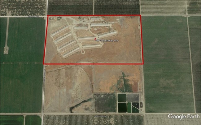
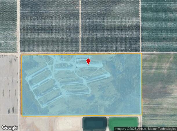
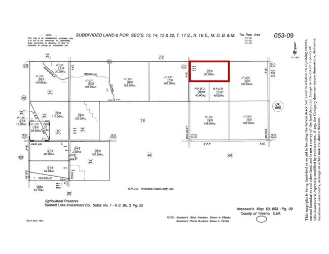
Property Record
19012 S Brawley Ave, Riverdale, CA 93656

NEARBY LISTINGS FOR SALE OR LEASE
Property Detail
19012 S Brawley Ave
Fresno, CA
Woodwards Addition
053-090-37S
S3515*19010 S BRAWLEY RI
Poultryranch
Fresno
X
California
06019C2900J
80 AC
2025
W Outlying Fresno County
2025
Fresno
007700
DEMOGRAPHICS near 19012 S Brawley Ave
1 mile
3 mile
5 mile
2024 Total Population
14
3,610
6,078
2029 Population
13
3,584
6,012
Pop Growth 2024-2029
(7.14%)
(0.72%)
(1.09%)
Average Age
35
34
35
2024 Total Households
4
992
1,673
HH Growth 2024-2029
0.00%
(0.81%)
(1.14%)
Median Household Inc
$67,500
$46,562
$54,846
Avg Household Size
3.00
3.50
3.50
2024 Avg HH Vehicles
3.00
2.00
2.00
Median Home Value
$399,999
$299,999
$320,721
Median Year Built
1974
1967
1971
Nearby Places
Map Layers
Map Styles
 Street
 Aerial
Transit
 Traffic
 Biking
Places
Listings with unknown addresses are not visible on the map
- Restaurants
- Banks
- Shops
- Fitness
- Groceries
PUBLIC TRANSPORTATION
AIRPORT
Fresno Yosemite International
Drive
Walk
Distance
Fresno Yosemite International
50 min
29.6 mi
Freight Ports
Port of Stockton
Drive
Walk
Distance
Port of Stockton
190 min
150.9 mi
SALE & LEASE HISTORY
LISTING DATE
SALE/LEASE

Apr 05, 2019
For Sale
Nearby Properties
Address
Land Use
TOTAL SIZE
Lot Size
Zoning
Address
Land Use
TOTAL SIZE
Lot Size
Zoning
155.20 AC
AE20
Address
Land Use
TOTAL SIZE
Lot Size
Zoning
2,183 SF
251.22 AC
AE20
Address
Land Use
TOTAL SIZE
Lot Size
Zoning
301.43 AC
AE20
Address
Land Use
TOTAL SIZE
Lot Size
Zoning
2,044 SF
156.38 AC
AE20
Address
Land Use
TOTAL SIZE
Lot Size
Zoning
25,688 SF
3.90 AC
CP
Address
Land Use
TOTAL SIZE
Lot Size
Zoning
1,840 SF
138.75 AC
AE20
Address
Land Use
TOTAL SIZE
Lot Size
Zoning
1,619 SF
160 AC
AE20
Address
Land Use
TOTAL SIZE
Lot Size
Zoning
3,041 SF
109.61 AC
AE20
Address
Land Use
TOTAL SIZE
Lot Size
Zoning
2,455 SF
112.68 AC
AE20
Address
Land Use
TOTAL SIZE
Lot Size
Zoning
295.77 AC
AE20
Address
Land Use
TOTAL SIZE
Lot Size
Zoning
78.80 AC
AE20
Address
Land Use
TOTAL SIZE
Lot Size
Zoning
36,174 SF
2.51 AC
R2
Address
Land Use
TOTAL SIZE
Lot Size
Zoning
3,592 SF
149.57 AC
AE20
Address
Land Use
TOTAL SIZE
Lot Size
Zoning
2,757 SF
156.36 AC
AE20
Address
Land Use
TOTAL SIZE
Lot Size
Zoning
3,146 SF
320 AC
AE20
Address
Land Use
TOTAL SIZE
Lot Size
Zoning
9,100 SF
0.53 AC
M1
Address
Land Use
TOTAL SIZE
Lot Size
Zoning
1,934 SF
218 AC
AE20
Address
Land Use
TOTAL SIZE
Lot Size
Zoning
1,224 SF
120 AC
AE20
Address
Land Use
TOTAL SIZE
Lot Size
Zoning
21,640 SF
3.85 AC
C6
Address
Land Use
TOTAL SIZE
Lot Size
Zoning
1,096 SF
75.50 AC
AE20
Address
Land Use
TOTAL SIZE
Lot Size
Zoning
1,417 SF
40 AC
AE20
Address
Land Use
TOTAL SIZE
Lot Size
Zoning
1,200 SF
247.83 AC
AE20
Address
Land Use
TOTAL SIZE
Lot Size
Zoning
85.65 AC
AE20
Address
Land Use
TOTAL SIZE
Lot Size
Zoning
133.43 AC
Address
Land Use
TOTAL SIZE
Lot Size
Zoning
1,560 SF
156.67 AC
AE20
Address
Land Use
TOTAL SIZE
Lot Size
Zoning
2,322 SF
158.50 AC
AE20
Address
Land Use
TOTAL SIZE
Lot Size
Zoning
158.18 AC
AE20
Address
Land Use
TOTAL SIZE
Lot Size
Zoning
158.18 AC
AE20
Address
Land Use
TOTAL SIZE
Lot Size
Zoning
1,134 SF
139.55 AC
AE20
The World's #1 Commercial Real Estate Marketplace
Connect with us
© 2026 CoStar Group
The information above has been obtained from sources believed reliable. While we do not doubt its accuracy we have not verified it and make no guarantee, warranty or representation about it. It is your responsibility to independently confirm its accuracy and completeness. Any projections, opinions, assumptions, or estimates used are for example only and do not represent the current or future performance of the property. The value of this transaction to you depends on tax and other factors which should be evaluated by your tax, financial, and legal advisors. You and your advisors should conduct a careful, independent investigation of the property to determine to your satisfaction the suitability of the property for your needs.