Property Record
1902 Carmalita St, Punta Gorda, FL 33950
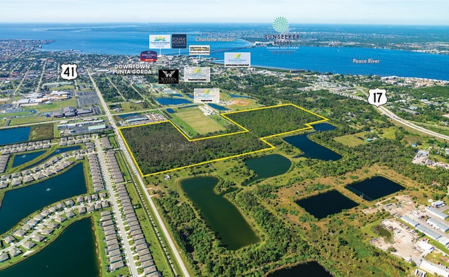
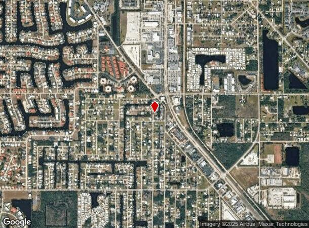
This Property Is For Sale
NEARBY LISTINGS FOR SALE OR LEASE
Property Detail
1902 Carmalita St
Punta Gorda, FL
Clays Sub
412308201001
8-41-23 P-1 20 AC. M/L LOTS 3 & 4 UNDIV 1/3 INT SEE 412308201002 & 412308201003 CASE #74-88 470/142-148 3303/592 4139/1226 4229/517 LOA5027/1318 5036/947 5036/950 5036/953 5036/956 5036/962 5036/968 5036/971 5036/974 5036/977
Residentialacreage
Charlotte
AE
Florida
12015C0242G
3,4
2022
19.96 AC
2022
Charlotte County
010301
Southwest Florida
DEMOGRAPHICS near 1902 Carmalita St
1 Mile
3 Mile
5 Mile
2024 Total Population
4,381
21,760
58,933
2029 Population
5,354
26,247
70,945
Pop Growth 2024-2029
+ 22.21%
+ 20.62%
+ 20.38%
Average Age
44
56
56
2024 Total Households
2,013
10,757
28,345
HH Growth 2024-2029
+ 22.31%
+ 20.79%
+ 20.69%
Median Household Inc
$29,023
$54,475
$58,322
Avg Household Size
2.20
2.00
2.00
2024 Avg HH Vehicles
1.00
2.00
2.00
Median Home Value
$202,329
$320,608
$280,121
Median Year Built
1997
1991
1990
Nearby Places
- Restaurants
- Banks
- Shops
- Fitness
- Groceries
PUBLIC TRANSPORTATION
AIRPORT
Punta Gorda
DRIVE
WALK
Distance
Punta Gorda
8 min
3.8 mi
Freight Ports
Port Manatee
DRIVE
WALK
Distance
Port Manatee
90 min
74.2 mi
Nearby Properties
Address
Land Use
TOTAL SIZE
Lot Size
Zoning
Address
Land Use
TOTAL SIZE
Lot Size
Zoning
333,027 SF
9.79 AC
CHRW
Address
Land Use
TOTAL SIZE
Lot Size
Zoning
349,844 SF
78.47 AC
P
Address
Land Use
TOTAL SIZE
Lot Size
Zoning
164,121 SF
44.20 AC
ECAP
Address
Land Use
TOTAL SIZE
Lot Size
Zoning
77,154 SF
10.30 AC
CC
Address
Land Use
TOTAL SIZE
Lot Size
Zoning
161,439 SF
171 AC
RE1
Address
Land Use
TOTAL SIZE
Lot Size
Zoning
265,949 SF
22.80 AC
PD-CC
Address
Land Use
TOTAL SIZE
Lot Size
Zoning
345,043 SF
33.12 AC
ECAP
Address
Land Use
TOTAL SIZE
Lot Size
Zoning
47,443 SF
7.94 AC
CC
Address
Land Use
TOTAL SIZE
Lot Size
Zoning
62,415 SF
281.65 AC
ECAP
Address
Land Use
TOTAL SIZE
Lot Size
Zoning
114,417 SF
4.36 AC
GM-15
Address
Land Use
TOTAL SIZE
Lot Size
Zoning
15,253 SF
13.27 AC
P
Address
Land Use
TOTAL SIZE
Lot Size
Zoning
198,916 SF
25.79 AC
HC
Address
Land Use
TOTAL SIZE
Lot Size
Zoning
208,560 SF
36.69 AC
PD-GM
Address
Land Use
TOTAL SIZE
Lot Size
Zoning
385,350 SF
374.81 AC
ECAP
Address
Land Use
TOTAL SIZE
Lot Size
Zoning
142,812 SF
7.89 AC
HC
Address
Land Use
TOTAL SIZE
Lot Size
Zoning
6,313 SF
15.49 AC
P
Address
Land Use
TOTAL SIZE
Lot Size
Zoning
73,095 SF
5 AC
NC
Address
Land Use
TOTAL SIZE
Lot Size
Zoning
44,185 SF
1.22 AC
CC
Address
Land Use
TOTAL SIZE
Lot Size
Zoning
25,356 SF
1.40 AC
CC
Address
Land Use
TOTAL SIZE
Lot Size
Zoning
96,845 SF
17.62 AC
HC
Address
Land Use
TOTAL SIZE
Lot Size
Zoning
82,379 SF
0.88 AC
CC
Address
Land Use
TOTAL SIZE
Lot Size
Zoning
12,159 SF
0.56 AC
CC
Address
Land Use
TOTAL SIZE
Lot Size
Zoning
24,880 SF
84.50 AC
PKR
Address
Land Use
TOTAL SIZE
Lot Size
Zoning
43,755 SF
8.19 AC
CC
Address
Land Use
TOTAL SIZE
Lot Size
Zoning
30,472 SF
3.19 AC
NR-10
Address
Land Use
TOTAL SIZE
Lot Size
Zoning
30,940 SF
0.42 AC
NC
Address
Land Use
TOTAL SIZE
Lot Size
Zoning
68,492 SF
6.38 AC
HC
Address
Land Use
TOTAL SIZE
Lot Size
Zoning
43,914 SF
4.06 AC
HC
Address
Land Use
TOTAL SIZE
Lot Size
Zoning
11.50 AC
CHRW
Address
Land Use
TOTAL SIZE
Lot Size
Zoning
63,902 SF
5.87 AC
HC
The World's #1 Commercial Real Estate Marketplace
Connect with us
© 2025 CoStar Group
The information above has been obtained from sources believed reliable. While we do not doubt its accuracy we have not verified it and make no guarantee, warranty or representation about it. It is your responsibility to independently confirm its accuracy and completeness. Any projections, opinions, assumptions, or estimates used are for example only and do not represent the current or future performance of the property. The value of this transaction to you depends on tax and other factors which should be evaluated by your tax, financial, and legal advisors. You and your advisors should conduct a careful, independent investigation of the property to determine to your satisfaction the suitability of the property for your needs.