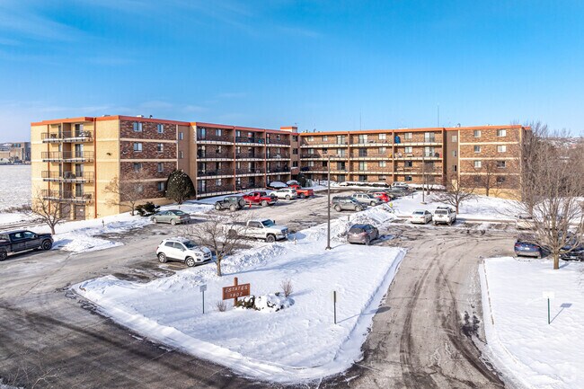
Property Record
1902 Saint Louis Ave, Duluth, MN 55802
Property Detail
1902 Saint Louis Ave
010270000002
PART OF LOT 1 LYING SLY OF THE NLY LINEOF LOTS 5 & 6 ST LOUIS AVE UPPER DULUTHEXTENDED WLY TO SHORELINE & NLY OFTHESLY LINE OF LOTS 5 & 6 ST LOUIS AVELOWER DULUTH EXTENDED WLY TO SHORELINE &WLY OF A LINE ASSUMING THE CENTER LINE SERIAL #
Apartment
Saint Louis
C2
Minnesota
AE The base floodplain where base flood elevations are provided. AE Zones are now used on new format FIRMs instead of A1-A30 Zones.
1,5-6
2026
2.18 AC
2024
Park Point
002200
Duluth
92,040 SF
Duluth, MN-WI
NEARBY LISTINGS FOR SALE OR LEASE
DEMOGRAPHICS near 1902 Saint Louis Ave
1 mile
3 mile
5 mile
2025 Total Population
892
28,519
80,526
2030 Population
903
28,195
79,377
Pop Growth 2025-2030
+ 1.23%
(1.14%)
(1.43%)
Average Age
55
38
39
2025 Total Households
435
13,853
34,515
HH Growth 2025-2030
+ 1.15%
(1.13%)
(1.61%)
Median Household Inc
$89,318
$39,846
$58,480
Avg Household Size
1.80
1.90
2.10
2025 Avg HH Vehicles
2.00
1.00
2.00
Median Home Value
$478,260
$189,018
$239,185
Median Year Built
1954
1948
1951
Nearby Places
Map Layers
Map Styles
 Street
 Aerial
Layers
 Traffic
 Biking
Places
Listings with unknown addresses are not visible on the map
- Restaurants
- Banks
- Shops
- Fitness
- Groceries
PUBLIC TRANSPORTATION
AIRPORT
Duluth International
Drive
Walk
Distance
Duluth International
27 min
10.4 mi
Nearby Properties
Address
Land Use
TOTAL SIZE
Lot Size
Zoning
Address
Land Use
TOTAL SIZE
Lot Size
Zoning
539,170 SF
0.49 AC
Address
Land Use
TOTAL SIZE
Lot Size
Zoning
338,800 SF
0.17 AC
Address
Land Use
TOTAL SIZE
Lot Size
Zoning
547,975 SF
18.72 AC
Address
Land Use
TOTAL SIZE
Lot Size
Zoning
391,335 SF
53.53 AC
Address
Land Use
TOTAL SIZE
Lot Size
Zoning
372,356 SF
1.35 AC
Address
Land Use
TOTAL SIZE
Lot Size
Zoning
175 AC
W1
Address
Land Use
TOTAL SIZE
Lot Size
Zoning
134,100 SF
0.17 AC
Address
Land Use
TOTAL SIZE
Lot Size
Zoning
148,777 SF
1.19 AC
Address
Land Use
TOTAL SIZE
Lot Size
Zoning
248,716 SF
1.02 AC
Address
Land Use
TOTAL SIZE
Lot Size
Zoning
40,835 SF
0.33 AC
Address
Land Use
TOTAL SIZE
Lot Size
Zoning
203,540 SF
0.24 AC
Address
Land Use
TOTAL SIZE
Lot Size
Zoning
97,552 SF
1.29 AC
Address
Land Use
TOTAL SIZE
Lot Size
Zoning
232,586 SF
0.16 AC
Address
Land Use
TOTAL SIZE
Lot Size
Zoning
2.81 AC
PDD
Address
Land Use
TOTAL SIZE
Lot Size
Zoning
178,184 SF
20 AC
Address
Land Use
TOTAL SIZE
Lot Size
Zoning
205,584 SF
0.81 AC
Address
Land Use
TOTAL SIZE
Lot Size
Zoning
178,104 SF
0.95 AC
Address
Land Use
TOTAL SIZE
Lot Size
Zoning
113,615 SF
0.32 AC
R4
Address
Land Use
TOTAL SIZE
Lot Size
Zoning
107,796 SF
9.19 AC
Address
Land Use
TOTAL SIZE
Lot Size
Zoning
175,168 SF
0.16 AC
Address
Land Use
TOTAL SIZE
Lot Size
Zoning
144,760 SF
0.56 AC
C4
Address
Land Use
TOTAL SIZE
Lot Size
Zoning
68,296 SF
0.38 AC
Address
Land Use
TOTAL SIZE
Lot Size
Zoning
97,157 SF
1.61 AC
Address
Land Use
TOTAL SIZE
Lot Size
Zoning
144,408 SF
1.29 AC
Address
Land Use
TOTAL SIZE
Lot Size
Zoning
372,356 SF
1.15 AC
Address
Land Use
TOTAL SIZE
Lot Size
Zoning
141,049 SF
0.50 AC
Address
Land Use
TOTAL SIZE
Lot Size
Zoning
8.50 AC
W1
Address
Land Use
TOTAL SIZE
Lot Size
Zoning
1.36 AC
C2
Address
Land Use
TOTAL SIZE
Lot Size
Zoning
100,800 SF
1.14 AC
C4
The World's #1 Commercial Real Estate Marketplace
Connect with us
© 2026 CoStar Group
The information above has been obtained from sources believed reliable. While we do not doubt its accuracy we have not verified it and make no guarantee, warranty or representation about it. It is your responsibility to independently confirm its accuracy and completeness. Any projections, opinions, assumptions, or estimates used are for example only and do not represent the current or future performance of the property. The value of this transaction to you depends on tax and other factors which should be evaluated by your tax, financial, and legal advisors. You and your advisors should conduct a careful, independent investigation of the property to determine to your satisfaction the suitability of the property for your needs.