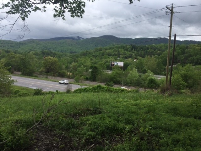
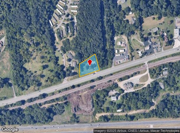
Property Record
1894 Us 70 Hwy, Swannanoa, NC 28778
NEARBY LISTINGS FOR SALE OR LEASE
Property Detail
1894 Us 70 Hwy
Asheville, NC
Buncombe
9678-78-6226-00000
North Carolina
Sfr
0.70 AC
X
Buncombe County
3700967800J
Asheville
864 SF
DEMOGRAPHICS near 1894 Us 70 Hwy
1 Mile
3 Mile
5 Mile
2024 Total Population
2,357
15,290
41,917
2029 Population
2,452
15,896
43,570
Pop Growth 2024-2029
+ 4.03%
+ 3.96%
+ 3.94%
Average Age
45
45
45
2024 Total Households
979
6,564
18,747
HH Growth 2024-2029
+ 3.47%
+ 3.37%
+ 3.40%
Median Household Inc
$64,186
$62,202
$63,632
Avg Household Size
2.20
2.20
2.10
2024 Avg HH Vehicles
2.00
2.00
2.00
Median Home Value
$272,754
$271,834
$316,881
Median Year Built
1987
1986
1987
Nearby Places
Map Layers
Map Styles
 Street
 Aerial
- Restaurants
- Banks
- Shops
- Fitness
- Groceries
PUBLIC TRANSPORTATION
AIRPORT
Asheville Regional
DRIVE
WALK
Distance
Asheville Regional
24 min
15.0 mi
Freight Ports
North Charleston Terminal
DRIVE
WALK
Distance
North Charleston Terminal
296 min
258.7 mi
SALE & LEASE HISTORY
LISTING DATE
SALE/LEASE

Jun 04, 2018
For Lease
Feb 28, 2017
For Sale
Nearby Properties
Address
Land Use
TOTAL SIZE
Lot Size
Zoning
Address
Land Use
TOTAL SIZE
Lot Size
Zoning
323,429 SF
1,005.50 AC
PS
Address
Land Use
TOTAL SIZE
Lot Size
Zoning
93,360 SF
12.51 AC
PS
Address
Land Use
TOTAL SIZE
Lot Size
Zoning
45.86 AC
INST
Address
Land Use
TOTAL SIZE
Lot Size
Zoning
100,643 SF
15.06 AC
INST
Address
Land Use
TOTAL SIZE
Lot Size
Zoning
44,450 SF
8.97 AC
PS
Address
Land Use
TOTAL SIZE
Lot Size
Zoning
90,832 SF
1,103.09 AC
CR
Address
Land Use
TOTAL SIZE
Lot Size
Zoning
492,052 SF
22.50 AC
EMP
Address
Land Use
TOTAL SIZE
Lot Size
Zoning
52,382 SF
12.50 AC
INST
Address
Land Use
TOTAL SIZE
Lot Size
Zoning
56,700 SF
18.38 AC
RM6
Address
Land Use
TOTAL SIZE
Lot Size
Zoning
33,037 SF
5.80 AC
RIVER
Address
Land Use
TOTAL SIZE
Lot Size
Zoning
48,806 SF
10.47 AC
INST
Address
Land Use
TOTAL SIZE
Lot Size
Zoning
31,494 SF
256 AC
PS
Address
Land Use
TOTAL SIZE
Lot Size
Zoning
26,618 SF
2.88 AC
HB
Address
Land Use
TOTAL SIZE
Lot Size
Zoning
8,260 SF
2.03 AC
LODG EXP
Address
Land Use
TOTAL SIZE
Lot Size
Zoning
31,640 SF
4.98 AC
INST
Address
Land Use
TOTAL SIZE
Lot Size
Zoning
20,158 SF
3.27 AC
HB
Address
Land Use
TOTAL SIZE
Lot Size
Zoning
38.41 AC
EMP
Address
Land Use
TOTAL SIZE
Lot Size
Zoning
68,648 SF
7.87 AC
CS
Address
Land Use
TOTAL SIZE
Lot Size
Zoning
35,199 SF
3 AC
CS
Address
Land Use
TOTAL SIZE
Lot Size
Zoning
27,840 SF
4.29 AC
NS
Address
Land Use
TOTAL SIZE
Lot Size
Zoning
13,766 SF
2.17 AC
HB
Address
Land Use
TOTAL SIZE
Lot Size
Zoning
8,316 SF
3.16 AC
INST
Address
Land Use
TOTAL SIZE
Lot Size
Zoning
213,584 SF
37.91 AC
EMP
Address
Land Use
TOTAL SIZE
Lot Size
Zoning
81,960 SF
0.50 AC
HB
Address
Land Use
TOTAL SIZE
Lot Size
Zoning
15,169 SF
29.38 AC
R-2
Address
Land Use
TOTAL SIZE
Lot Size
Zoning
28,893 SF
3.61 AC
R-1
Address
Land Use
TOTAL SIZE
Lot Size
Zoning
152,109 SF
6.02 AC
CS
Address
Land Use
TOTAL SIZE
Lot Size
Zoning
33,722 SF
8.80 AC
CS
Address
Land Use
TOTAL SIZE
Lot Size
Zoning
12,840 SF
3.78 AC
R-3
Address
Land Use
TOTAL SIZE
Lot Size
Zoning
13,759 SF
10 AC
R-2
The World's #1 Commercial Real Estate Marketplace
Connect with us
© 2025 CoStar Group
The information above has been obtained from sources believed reliable. While we do not doubt its accuracy we have not verified it and make no guarantee, warranty or representation about it. It is your responsibility to independently confirm its accuracy and completeness. Any projections, opinions, assumptions, or estimates used are for example only and do not represent the current or future performance of the property. The value of this transaction to you depends on tax and other factors which should be evaluated by your tax, financial, and legal advisors. You and your advisors should conduct a careful, independent investigation of the property to determine to your satisfaction the suitability of the property for your needs.