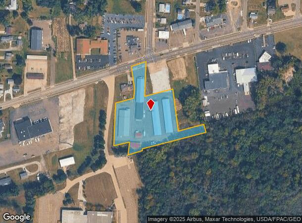
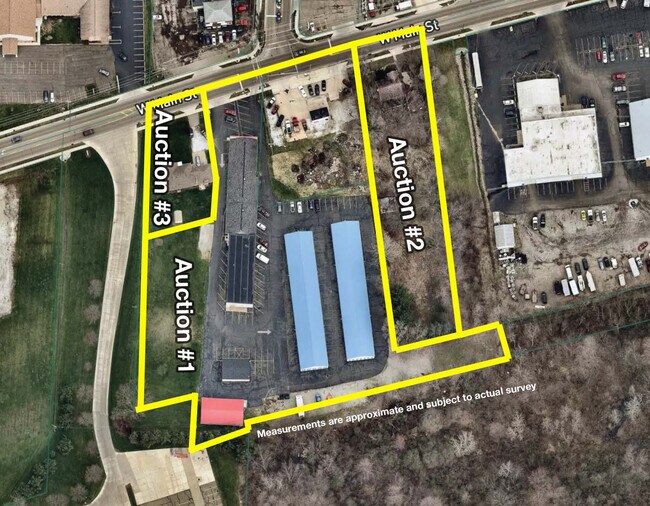
Property Record
1904 W Main St, Louisville, OH 44641

NEARBY LISTINGS FOR SALE OR LEASE
-
-
View all Louisville listings for sale on LoopNet.com
Property Detail
1904 W Main St
10001827
OL 370 3.04A
Warehouse
Stark
X
Ohio
39151C0234E
3.04 AC
0
Stark County
2025
Cleveland
712601
Canton-Massillon, OH
36,202 SF
DEMOGRAPHICS near 1904 W Main St
1 Mile
3 Mile
5 Mile
2024 Total Population
2,890
24,438
67,361
2029 Population
2,862
24,258
67,017
Pop Growth 2024-2029
(0.97%)
(0.74%)
(0.51%)
Average Age
40
41
41
2024 Total Households
1,190
9,988
27,627
HH Growth 2024-2029
(1.01%)
(0.75%)
(0.57%)
Median Household Inc
$67,449
$55,685
$55,610
Avg Household Size
2.40
2.40
2.30
2024 Avg HH Vehicles
2.00
2.00
2.00
Median Home Value
$157,596
$149,500
$148,431
Median Year Built
1965
1965
1962
Nearby Places
Map Layers
Map Styles
 Street
 Aerial
- Restaurants
- Banks
- Shops
- Fitness
- Groceries
PUBLIC TRANSPORTATION
AIRPORT
Akron-Canton Regional
DRIVE
WALK
Distance
Akron-Canton Regional
23 min
15.1 mi
SALE & LEASE HISTORY
LISTING DATE
SALE/LEASE

Apr 06, 2021
For Sale
Nearby Properties
Address
Land Use
TOTAL SIZE
Lot Size
Zoning
Address
Land Use
TOTAL SIZE
Lot Size
Zoning
91.83 AC
Address
Land Use
TOTAL SIZE
Lot Size
Zoning
125,619 SF
13.15 AC
Address
Land Use
TOTAL SIZE
Lot Size
Zoning
272,327 SF
23.62 AC
Address
Land Use
TOTAL SIZE
Lot Size
Zoning
129,374 SF
63.36 AC
Address
Land Use
TOTAL SIZE
Lot Size
Zoning
141,077 SF
21.73 AC
Address
Land Use
TOTAL SIZE
Lot Size
Zoning
109,663 SF
4.26 AC
Address
Land Use
TOTAL SIZE
Lot Size
Zoning
476,634 SF
15.08 AC
Address
Land Use
TOTAL SIZE
Lot Size
Zoning
681,718 SF
35.20 AC
Address
Land Use
TOTAL SIZE
Lot Size
Zoning
202,684 SF
40.97 AC
Address
Land Use
TOTAL SIZE
Lot Size
Zoning
133,991 SF
24.51 AC
Address
Land Use
TOTAL SIZE
Lot Size
Zoning
153,834 SF
20.21 AC
Address
Land Use
TOTAL SIZE
Lot Size
Zoning
217,695 SF
19.46 AC
Address
Land Use
TOTAL SIZE
Lot Size
Zoning
52,876 SF
4.96 AC
Address
Land Use
TOTAL SIZE
Lot Size
Zoning
118,052 SF
12.52 AC
Address
Land Use
TOTAL SIZE
Lot Size
Zoning
81,369 SF
3 AC
Address
Land Use
TOTAL SIZE
Lot Size
Zoning
124,064 SF
3.52 AC
Address
Land Use
TOTAL SIZE
Lot Size
Zoning
1,083,703 SF
91.83 AC
Address
Land Use
TOTAL SIZE
Lot Size
Zoning
101,463 SF
8.85 AC
Address
Land Use
TOTAL SIZE
Lot Size
Zoning
68,419 SF
8.93 AC
Address
Land Use
TOTAL SIZE
Lot Size
Zoning
51,131 SF
9.73 AC
Address
Land Use
TOTAL SIZE
Lot Size
Zoning
187,797 SF
20.29 AC
Address
Land Use
TOTAL SIZE
Lot Size
Zoning
14,070 SF
10.04 AC
Address
Land Use
TOTAL SIZE
Lot Size
Zoning
49,900 SF
1.31 AC
Address
Land Use
TOTAL SIZE
Lot Size
Zoning
54,593 SF
10.66 AC
Address
Land Use
TOTAL SIZE
Lot Size
Zoning
52,324 SF
8.52 AC
Address
Land Use
TOTAL SIZE
Lot Size
Zoning
11,179 SF
79.99 AC
Address
Land Use
TOTAL SIZE
Lot Size
Zoning
28,777 SF
3.24 AC
Address
Land Use
TOTAL SIZE
Lot Size
Zoning
86,331 SF
3.67 AC
Address
Land Use
TOTAL SIZE
Lot Size
Zoning
120,000 SF
6.53 AC
Address
Land Use
TOTAL SIZE
Lot Size
Zoning
22,341 SF
11.09 AC
The World's #1 Commercial Real Estate Marketplace
Connect with us
© 2026 CoStar Group
The information above has been obtained from sources believed reliable. While we do not doubt its accuracy we have not verified it and make no guarantee, warranty or representation about it. It is your responsibility to independently confirm its accuracy and completeness. Any projections, opinions, assumptions, or estimates used are for example only and do not represent the current or future performance of the property. The value of this transaction to you depends on tax and other factors which should be evaluated by your tax, financial, and legal advisors. You and your advisors should conduct a careful, independent investigation of the property to determine to your satisfaction the suitability of the property for your needs.