Property Record
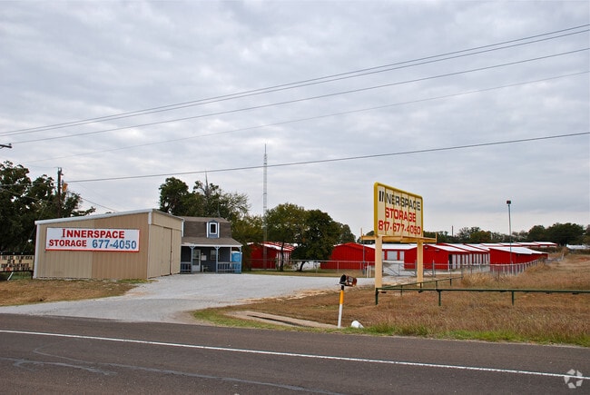
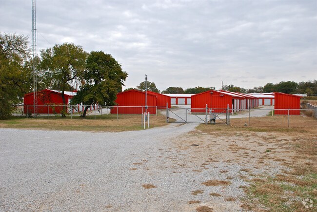
1905 E Highway 199, Springtown, TX 76082

Property Detail
1905 E Highway 199
R000047342
ACRES: 2.000 ABST: 899,
Commercialnec
PARKER
B and X Area of moderate flood hazard, usually the area between the limits of the 100-year and 500-year floods.
Texas
2024
2 AC
2025
Parker County
140403
Dallas/Ft Worth
20,500 SF
Dallas-Fort Worth-Arlington, TX
NEARBY LISTINGS FOR SALE OR LEASE
-
-
View all Springtown listings for sale on LoopNet.com
DEMOGRAPHICS near 1905 E Highway 199
1 mile
3 mile
5 mile
2025 Total Population
1,201
14,000
29,142
2030 Population
1,403
16,334
34,083
Pop Growth 2025-2030
+ 16.82%
+ 16.67%
+ 16.95%
Average Age
40
39
40
2025 Total Households
432
4,924
10,305
HH Growth 2025-2030
+ 15.97%
+ 15.88%
+ 16.20%
Median Household Inc
$97,530
$90,425
$91,594
Avg Household Size
2.70
2.80
2.70
2025 Avg HH Vehicles
2.00
2.00
2.00
Median Home Value
$333,654
$290,859
$337,771
Median Year Built
2004
2002
2001
Nearby Places
Map Layers
Map Styles
 Street
 Aerial
Transit
 Traffic
 Biking
Places
Listings with unknown addresses are not visible on the map
- Restaurants
- Banks
- Shops
- Fitness
- Groceries
Nearby Properties
Address
Land Use
TOTAL SIZE
Lot Size
Zoning
Address
Land Use
TOTAL SIZE
Lot Size
Zoning
65,806 SF
5.83 AC
Address
Land Use
TOTAL SIZE
Lot Size
Zoning
41,629 SF
4.66 AC
Address
Land Use
TOTAL SIZE
Lot Size
Zoning
49,110 SF
6.13 AC
Address
Land Use
TOTAL SIZE
Lot Size
Zoning
585 SF
7.25 AC
Address
Land Use
TOTAL SIZE
Lot Size
Zoning
21,544 SF
2 AC
Address
Land Use
TOTAL SIZE
Lot Size
Zoning
16,200 SF
9.28 AC
Address
Land Use
TOTAL SIZE
Lot Size
Zoning
28,300 SF
2.10 AC
Address
Land Use
TOTAL SIZE
Lot Size
Zoning
Address
Land Use
TOTAL SIZE
Lot Size
Zoning
17,748 SF
5.55 AC
Address
Land Use
TOTAL SIZE
Lot Size
Zoning
20,628 SF
2 AC
Address
Land Use
TOTAL SIZE
Lot Size
Zoning
5,000 SF
7.73 AC
Address
Land Use
TOTAL SIZE
Lot Size
Zoning
900 SF
11.21 AC
Address
Land Use
TOTAL SIZE
Lot Size
Zoning
5,600 SF
1.98 AC
Address
Land Use
TOTAL SIZE
Lot Size
Zoning
15,354 SF
3 AC
Address
Land Use
TOTAL SIZE
Lot Size
Zoning
19,712 SF
0.28 AC
Address
Land Use
TOTAL SIZE
Lot Size
Zoning
4,000 SF
5.03 AC
Address
Land Use
TOTAL SIZE
Lot Size
Zoning
6,378 SF
9.16 AC
Address
Land Use
TOTAL SIZE
Lot Size
Zoning
14,300 SF
1.45 AC
Address
Land Use
TOTAL SIZE
Lot Size
Zoning
9,000 SF
9.99 AC
Address
Land Use
TOTAL SIZE
Lot Size
Zoning
4,000 SF
3 AC
Address
Land Use
TOTAL SIZE
Lot Size
Zoning
15,000 SF
2.28 AC
Address
Land Use
TOTAL SIZE
Lot Size
Zoning
4,640 SF
1.68 AC
Address
Land Use
TOTAL SIZE
Lot Size
Zoning
9,142 SF
3.07 AC
Address
Land Use
TOTAL SIZE
Lot Size
Zoning
45,000 SF
9.88 AC
Address
Land Use
TOTAL SIZE
Lot Size
Zoning
5,001 SF
1.01 AC
Address
Land Use
TOTAL SIZE
Lot Size
Zoning
9,900 SF
0.68 AC
Address
Land Use
TOTAL SIZE
Lot Size
Zoning
9,100 SF
1.32 AC
Address
Land Use
TOTAL SIZE
Lot Size
Zoning
7,360 SF
1.28 AC
Address
Land Use
TOTAL SIZE
Lot Size
Zoning
7,200 SF
1.03 AC
The World's #1 Commercial Real Estate Marketplace
Connect with us
© 2026 CoStar Group
The information above has been obtained from sources believed reliable. While we do not doubt its accuracy we have not verified it and make no guarantee, warranty or representation about it. It is your responsibility to independently confirm its accuracy and completeness. Any projections, opinions, assumptions, or estimates used are for example only and do not represent the current or future performance of the property. The value of this transaction to you depends on tax and other factors which should be evaluated by your tax, financial, and legal advisors. You and your advisors should conduct a careful, independent investigation of the property to determine to your satisfaction the suitability of the property for your needs.