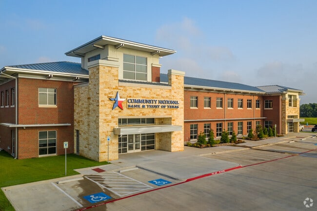
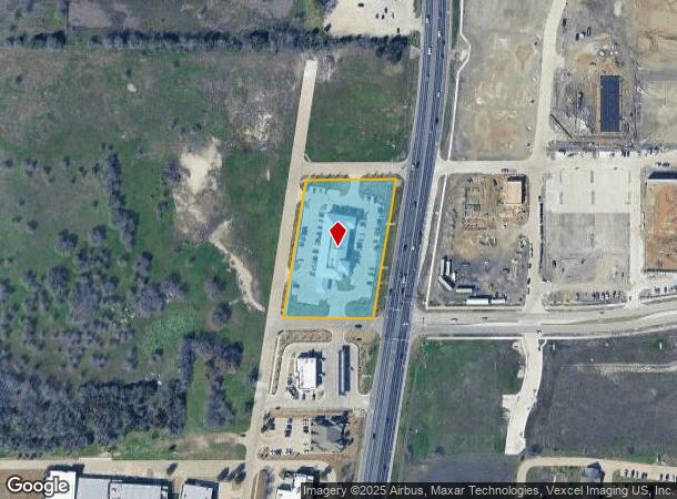
Property Record
1905 N Highway 77, Waxahachie, TX 75165

NEARBY LISTINGS FOR SALE OR LEASE
-
-
View all Waxahachie listings for lease on LoopNet.com
Property Detail
1905 N Highway 77
Dallas-Fort Worth-Arlington, TX
Victory Park Rev
262426
LOT 1R BLK B VICTORY PARK REV 2.4699 AC
Commercialnec
Ellis
X
Texas
48139C0190G
1r
2024
2.47 AC
2025
Ellis County
060212
Dallas/Ft Worth
28,514 SF
DEMOGRAPHICS near 1905 N Highway 77
1 Mile
3 Mile
5 Mile
2024 Total Population
5,215
40,678
63,213
2029 Population
6,747
51,508
80,036
Pop Growth 2024-2029
+ 29.38%
+ 26.62%
+ 26.61%
Average Age
34
37
37
2024 Total Households
1,751
14,333
21,982
HH Growth 2024-2029
+ 29.35%
+ 26.74%
+ 26.83%
Median Household Inc
$82,915
$91,275
$86,838
Avg Household Size
2.90
2.70
2.80
2024 Avg HH Vehicles
2.00
2.00
2.00
Median Home Value
$260,192
$265,178
$271,904
Median Year Built
2011
2002
2000
Nearby Places
Map Layers
Map Styles
 Street
 Aerial
- Restaurants
- Banks
- Shops
- Fitness
- Groceries
PUBLIC TRANSPORTATION
AIRPORT
Dallas Love Field
DRIVE
WALK
Distance
Dallas Love Field
43 min
30.5 mi
Freight Ports
Port of Shreveport
DRIVE
WALK
Distance
Port of Shreveport
229 min
211.7 mi
SALE & LEASE HISTORY
LISTING DATE
SALE/LEASE

Jan 15, 2020
For Lease
Nearby Properties
Address
Land Use
TOTAL SIZE
Lot Size
Zoning
Address
Land Use
TOTAL SIZE
Lot Size
Zoning
488,705 SF
43.76 AC
Address
Land Use
TOTAL SIZE
Lot Size
Zoning
630,460 SF
71.82 AC
Address
Land Use
TOTAL SIZE
Lot Size
Zoning
146,074 SF
42.83 AC
Address
Land Use
TOTAL SIZE
Lot Size
Zoning
448,643 SF
8.93 AC
Address
Land Use
TOTAL SIZE
Lot Size
Zoning
643,064 SF
42.15 AC
Address
Land Use
TOTAL SIZE
Lot Size
Zoning
408,068 SF
7.42 AC
Address
Land Use
TOTAL SIZE
Lot Size
Zoning
259,166 SF
11.07 AC
Address
Land Use
TOTAL SIZE
Lot Size
Zoning
675,375 SF
59.26 AC
Address
Land Use
TOTAL SIZE
Lot Size
Zoning
424,436 SF
11.87 AC
Address
Land Use
TOTAL SIZE
Lot Size
Zoning
285,936 SF
12.66 AC
Address
Land Use
TOTAL SIZE
Lot Size
Zoning
258,147 SF
12.40 AC
Address
Land Use
TOTAL SIZE
Lot Size
Zoning
177,000 SF
20.25 AC
Address
Land Use
TOTAL SIZE
Lot Size
Zoning
708,800 SF
149.18 AC
Address
Land Use
TOTAL SIZE
Lot Size
Zoning
198,180 SF
11.48 AC
Address
Land Use
TOTAL SIZE
Lot Size
Zoning
1,123,347 SF
74.97 AC
Address
Land Use
TOTAL SIZE
Lot Size
Zoning
182,574 SF
7.79 AC
Address
Land Use
TOTAL SIZE
Lot Size
Zoning
413,050 SF
54.30 AC
Address
Land Use
TOTAL SIZE
Lot Size
Zoning
134,530 SF
12.11 AC
Address
Land Use
TOTAL SIZE
Lot Size
Zoning
107,800 SF
18.46 AC
Address
Land Use
TOTAL SIZE
Lot Size
Zoning
178,880 SF
5.51 AC
Address
Land Use
TOTAL SIZE
Lot Size
Zoning
150,886 SF
11.02 AC
Address
Land Use
TOTAL SIZE
Lot Size
Zoning
63,720 SF
17.38 AC
Address
Land Use
TOTAL SIZE
Lot Size
Zoning
85,823 SF
56.24 AC
Address
Land Use
TOTAL SIZE
Lot Size
Zoning
118,782 SF
5.11 AC
Address
Land Use
TOTAL SIZE
Lot Size
Zoning
326,740 SF
23.01 AC
Address
Land Use
TOTAL SIZE
Lot Size
Zoning
352,350 SF
18.78 AC
Address
Land Use
TOTAL SIZE
Lot Size
Zoning
568,234 SF
65.79 AC
Address
Land Use
TOTAL SIZE
Lot Size
Zoning
886,858 SF
8.60 AC
Address
Land Use
TOTAL SIZE
Lot Size
Zoning
68,564 SF
11.14 AC
Address
Land Use
TOTAL SIZE
Lot Size
Zoning
109,978 SF
28.14 AC
The World's #1 Commercial Real Estate Marketplace
Connect with us
© 2026 CoStar Group
The information above has been obtained from sources believed reliable. While we do not doubt its accuracy we have not verified it and make no guarantee, warranty or representation about it. It is your responsibility to independently confirm its accuracy and completeness. Any projections, opinions, assumptions, or estimates used are for example only and do not represent the current or future performance of the property. The value of this transaction to you depends on tax and other factors which should be evaluated by your tax, financial, and legal advisors. You and your advisors should conduct a careful, independent investigation of the property to determine to your satisfaction the suitability of the property for your needs.