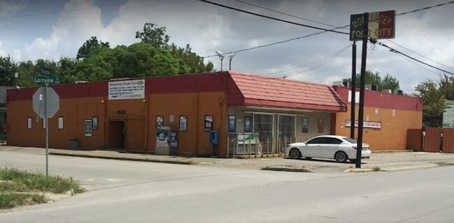
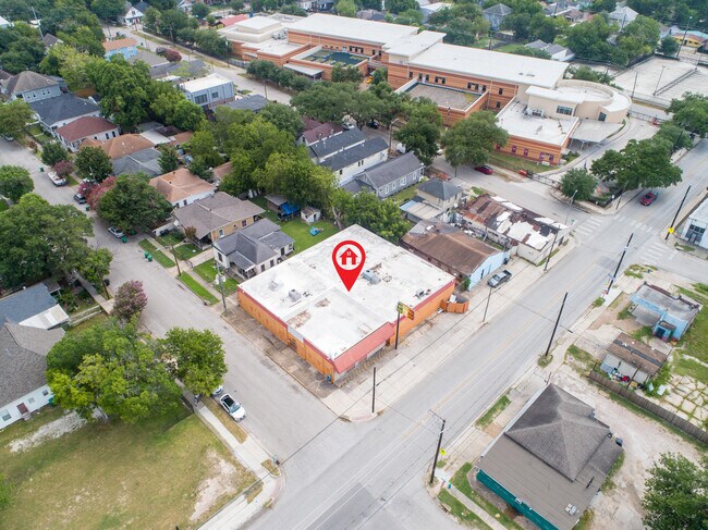
Property Record
1906 Chapman St, Houston, TX 77009
NEARBY LISTINGS FOR SALE OR LEASE
Property Detail
1906 Chapman St
Houston-The Woodlands-Sugar Land, TX
Cascara
0090470000025
LTS 25 & 26 BLK 5 CASCARA
Supermarket
Harris
X
Texas
48201C0690N
25,26
2024
0.11 AC
2025
North Inner Loop
212300
Houston
7,656 SF
DEMOGRAPHICS near 1906 Chapman St
1 Mile
3 Mile
5 Mile
2024 Total Population
23,011
176,840
439,890
2029 Population
23,713
184,346
457,348
Pop Growth 2024-2029
+ 3.05%
+ 4.24%
+ 3.97%
Average Age
37
37
37
2024 Total Households
5,651
77,642
189,324
HH Growth 2024-2029
+ 5.10%
+ 4.59%
+ 4.24%
Median Household Inc
$36,787
$72,304
$70,803
Avg Household Size
2.50
2.10
2.20
2024 Avg HH Vehicles
1.00
2.00
2.00
Median Home Value
$213,049
$347,129
$374,648
Median Year Built
1960
1995
1989
Nearby Places
Map Layers
Map Styles
 Street
 Aerial
- Restaurants
- Banks
- Shops
- Fitness
- Groceries
PUBLIC TRANSPORTATION
TRANSIT/SUBWAY
Burnett Transit Center/Casa De Amigos (Redline - Harris County Metropolitan Transit Authority METRO Rail (METRORail))
DRIVE
WALK
Distance
Burnett Transit Center/Casa De Amigos (Redline - Harris County Metropolitan Transit Authority METRO Rail (METRORail))
1 min
13 min
0.7 mi
Fulton / North Central (METRORAIL RED LINE - Metropolitan Transit Authority of Harris County, Redline - Metropolitan Transit Authority of Harris County)
DRIVE
WALK
Distance
Fulton / North Central (METRORAIL RED LINE - Metropolitan Transit Authority of Harris County, Redline - Metropolitan Transit Authority of Harris County)
2 min
16 min
0.8 mi
Quitman / Near Northside (METRORAIL RED LINE - Metropolitan Transit Authority of Harris County, Redline - Metropolitan Transit Authority of Harris County)
DRIVE
WALK
Distance
Quitman / Near Northside (METRORAIL RED LINE - Metropolitan Transit Authority of Harris County, Redline - Metropolitan Transit Authority of Harris County)
1 min
16 min
0.8 mi
Quitman Near Northside Nb (METRORAIL RED LINE - Metropolitan Transit Authority of Harris County)
DRIVE
WALK
Distance
Quitman Near Northside Nb (METRORAIL RED LINE - Metropolitan Transit Authority of Harris County)
1 min
16 min
0.9 mi
COMMUTER RAIL
Houston (Sunset Limited - Amtrak)
DRIVE
WALK
Distance
Houston (Sunset Limited - Amtrak)
4 min
2.0 mi
AIRPORT
William P Hobby
DRIVE
WALK
Distance
William P Hobby
26 min
14.6 mi
George Bush Intcntl/Houston
DRIVE
WALK
Distance
George Bush Intcntl/Houston
23 min
18.0 mi
Freight Ports
Port of Houston
DRIVE
WALK
Distance
Port of Houston
18 min
8.4 mi
SALE & LEASE HISTORY
LISTING DATE
SALE/LEASE

Sep 06, 2023
For Sale
Jun 27, 2022
For Sale
Jul 24, 2023
For Lease
Jul 21, 2022
For Sale
Nearby Properties
Address
Land Use
TOTAL SIZE
Lot Size
Zoning
Address
Land Use
TOTAL SIZE
Lot Size
Zoning
1,383,720 SF
1.47 AC
Address
Land Use
TOTAL SIZE
Lot Size
Zoning
1,101,686 SF
1.45 AC
Address
Land Use
TOTAL SIZE
Lot Size
Zoning
973,861 SF
1.18 AC
Address
Land Use
TOTAL SIZE
Lot Size
Zoning
899,279 SF
1.18 AC
Address
Land Use
TOTAL SIZE
Lot Size
Zoning
797,208 SF
1.46 AC
Address
Land Use
TOTAL SIZE
Lot Size
Zoning
1,916,394 SF
1.46 AC
Address
Land Use
TOTAL SIZE
Lot Size
Zoning
1,871,418 SF
1.44 AC
Address
Land Use
TOTAL SIZE
Lot Size
Zoning
1,091,726 SF
2.60 AC
Address
Land Use
TOTAL SIZE
Lot Size
Zoning
1,232,364 SF
1.49 AC
Address
Land Use
TOTAL SIZE
Lot Size
Zoning
1,436,400 SF
1.44 AC
Address
Land Use
TOTAL SIZE
Lot Size
Zoning
1,321,033 SF
1.46 AC
Address
Land Use
TOTAL SIZE
Lot Size
Zoning
4,169,721 SF
31.23 AC
Address
Land Use
TOTAL SIZE
Lot Size
Zoning
2,005,097 SF
1.44 AC
Address
Land Use
TOTAL SIZE
Lot Size
Zoning
1,374,271 SF
1.44 AC
Address
Land Use
TOTAL SIZE
Lot Size
Zoning
1,150,681 SF
1.17 AC
Address
Land Use
TOTAL SIZE
Lot Size
Zoning
515,025 SF
1.50 AC
Address
Land Use
TOTAL SIZE
Lot Size
Zoning
1,657,484 SF
1.44 AC
Address
Land Use
TOTAL SIZE
Lot Size
Zoning
1,282,908 SF
2.74 AC
Address
Land Use
TOTAL SIZE
Lot Size
Zoning
1,311,133 SF
1.44 AC
Address
Land Use
TOTAL SIZE
Lot Size
Zoning
1,181,384 SF
1.47 AC
Address
Land Use
TOTAL SIZE
Lot Size
Zoning
1,162,204 SF
1.44 AC
Address
Land Use
TOTAL SIZE
Lot Size
Zoning
934,258 SF
1.45 AC
Address
Land Use
TOTAL SIZE
Lot Size
Zoning
1,103,424 SF
1.44 AC
Address
Land Use
TOTAL SIZE
Lot Size
Zoning
1,365,801 SF
1.44 AC
Address
Land Use
TOTAL SIZE
Lot Size
Zoning
1,017,783 SF
1.44 AC
Address
Land Use
TOTAL SIZE
Lot Size
Zoning
1,182,525 SF
1.11 AC
Address
Land Use
TOTAL SIZE
Lot Size
Zoning
608,233 SF
2.23 AC
Address
Land Use
TOTAL SIZE
Lot Size
Zoning
930,730 SF
1.89 AC
Address
Land Use
TOTAL SIZE
Lot Size
Zoning
612,078 SF
1.44 AC
Address
Land Use
TOTAL SIZE
Lot Size
Zoning
468,513 SF
0.86 AC
The World's #1 Commercial Real Estate Marketplace
Connect with us
© 2025 CoStar Group
The information above has been obtained from sources believed reliable. While we do not doubt its accuracy we have not verified it and make no guarantee, warranty or representation about it. It is your responsibility to independently confirm its accuracy and completeness. Any projections, opinions, assumptions, or estimates used are for example only and do not represent the current or future performance of the property. The value of this transaction to you depends on tax and other factors which should be evaluated by your tax, financial, and legal advisors. You and your advisors should conduct a careful, independent investigation of the property to determine to your satisfaction the suitability of the property for your needs.