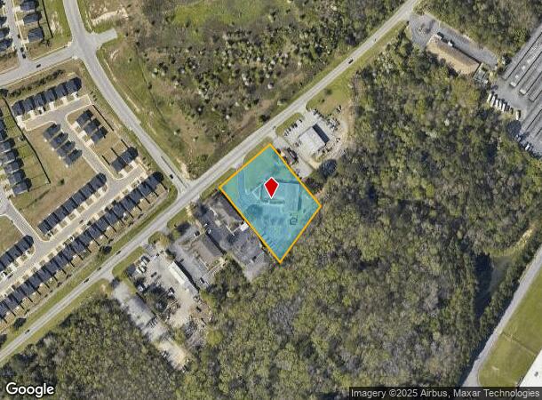
Property Record
1900 Pineview Dr, Columbia, SC 29209

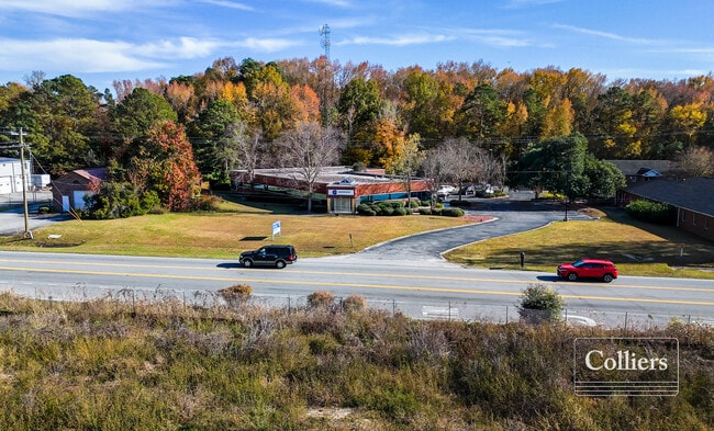
This Property Is For Sale
NEARBY LISTINGS FOR SALE OR LEASE
-
-
View all Columbia listings for sale on LoopNet.com
Property Detail
1900 Pineview Dr
19000-01-02
Garners Ferry
Commercialnec
245.1X326.9X215.5X384.7 #SU #PR 53-161 RB2270-2667
X
Richland
45079C0383L
South Carolina
2025
2 AC
2024
Southeast Columbia
011607
Columbia
10,248 SF
Columbia, SC
DEMOGRAPHICS near 1900 Pineview Dr
1 mile
3 mile
5 mile
2024 Total Population
5,351
30,834
71,039
2029 Population
5,455
31,146
72,069
Pop Growth 2024-2029
+ 1.94%
+ 1.01%
+ 1.45%
Average Age
36
39
36
2024 Total Households
2,340
12,721
26,814
HH Growth 2024-2029
+ 1.97%
+ 1.07%
+ 1.55%
Median Household Inc
$50,442
$59,427
$56,970
Avg Household Size
2.20
2.30
2.30
2024 Avg HH Vehicles
1.00
2.00
2.00
Median Home Value
$150,328
$178,125
$194,198
Median Year Built
1990
1986
1981
Nearby Places
Map Layers
Map Styles
 Street
 Aerial
Transit
 Traffic
 Biking
Places
Listings with unknown addresses are not visible on the map
- Restaurants
- Banks
- Shops
- Fitness
- Groceries
PUBLIC TRANSPORTATION
COMMUTER RAIL
Drive
Walk
Distance
17 min
8.7 mi
AIRPORT
Columbia Metro
Drive
Walk
Distance
Columbia Metro
30 min
17.9 mi
Nearby Properties
Address
Land Use
TOTAL SIZE
Lot Size
Zoning
Address
Land Use
TOTAL SIZE
Lot Size
Zoning
460,078 SF
42.80 AC
M-1
Address
Land Use
TOTAL SIZE
Lot Size
Zoning
241,878 SF
14.03 AC
C-3
Address
Land Use
TOTAL SIZE
Lot Size
Zoning
3,000 SF
52.49 AC
O-I
Address
Land Use
TOTAL SIZE
Lot Size
Zoning
95.26 AC
C-1
Address
Land Use
TOTAL SIZE
Lot Size
Zoning
230,053 SF
18.35 AC
C-3
Address
Land Use
TOTAL SIZE
Lot Size
Zoning
32,640 SF
23.73 AC
RSF-2
Address
Land Use
TOTAL SIZE
Lot Size
Zoning
294,105 SF
19 AC
RG-2
Address
Land Use
TOTAL SIZE
Lot Size
Zoning
114,225 SF
14.84 AC
PDD
Address
Land Use
TOTAL SIZE
Lot Size
Zoning
212,787 SF
26.93 AC
C-3
Address
Land Use
TOTAL SIZE
Lot Size
Zoning
281,304 SF
22.86 AC
RG-2
Address
Land Use
TOTAL SIZE
Lot Size
Zoning
285,760 SF
16.12 AC
RG-2
Address
Land Use
TOTAL SIZE
Lot Size
Zoning
62,250 SF
8.15 AC
GC
Address
Land Use
TOTAL SIZE
Lot Size
Zoning
199,263 SF
18.29 AC
C-3
Address
Land Use
TOTAL SIZE
Lot Size
Zoning
160,954 SF
24.03 AC
C-3
Address
Land Use
TOTAL SIZE
Lot Size
Zoning
247,744 SF
15.32 AC
RM-HD
Address
Land Use
TOTAL SIZE
Lot Size
Zoning
68,216 SF
1.84 AC
C-3
Address
Land Use
TOTAL SIZE
Lot Size
Zoning
297,892 SF
10.99 AC
M-2
Address
Land Use
TOTAL SIZE
Lot Size
Zoning
68,012 SF
13.18 AC
M-1
Address
Land Use
TOTAL SIZE
Lot Size
Zoning
140,100 SF
7.12 AC
M-2
Address
Land Use
TOTAL SIZE
Lot Size
Zoning
180,828 SF
17.24 AC
RSF-3
Address
Land Use
TOTAL SIZE
Lot Size
Zoning
65,107 SF
1.67 AC
C-3
Address
Land Use
TOTAL SIZE
Lot Size
Zoning
45,530 SF
4.72 AC
D-1
Address
Land Use
TOTAL SIZE
Lot Size
Zoning
26,427 SF
2.27 AC
PUD-C
Address
Land Use
TOTAL SIZE
Lot Size
Zoning
45,883 SF
5.11 AC
GC
Address
Land Use
TOTAL SIZE
Lot Size
Zoning
194,172 SF
15.51 AC
GC
Address
Land Use
TOTAL SIZE
Lot Size
Zoning
56.15 AC
PDD
Address
Land Use
TOTAL SIZE
Lot Size
Zoning
1,676 SF
8.03 AC
RG-2
Address
Land Use
TOTAL SIZE
Lot Size
Zoning
55,828 SF
2.68 AC
C-3
Address
Land Use
TOTAL SIZE
Lot Size
Zoning
75,034 SF
2.46 AC
GC
Address
Land Use
TOTAL SIZE
Lot Size
Zoning
16,140 SF
1.84 AC
PD
The World's #1 Commercial Real Estate Marketplace
Connect with us
© 2026 CoStar Group
The information above has been obtained from sources believed reliable. While we do not doubt its accuracy we have not verified it and make no guarantee, warranty or representation about it. It is your responsibility to independently confirm its accuracy and completeness. Any projections, opinions, assumptions, or estimates used are for example only and do not represent the current or future performance of the property. The value of this transaction to you depends on tax and other factors which should be evaluated by your tax, financial, and legal advisors. You and your advisors should conduct a careful, independent investigation of the property to determine to your satisfaction the suitability of the property for your needs.