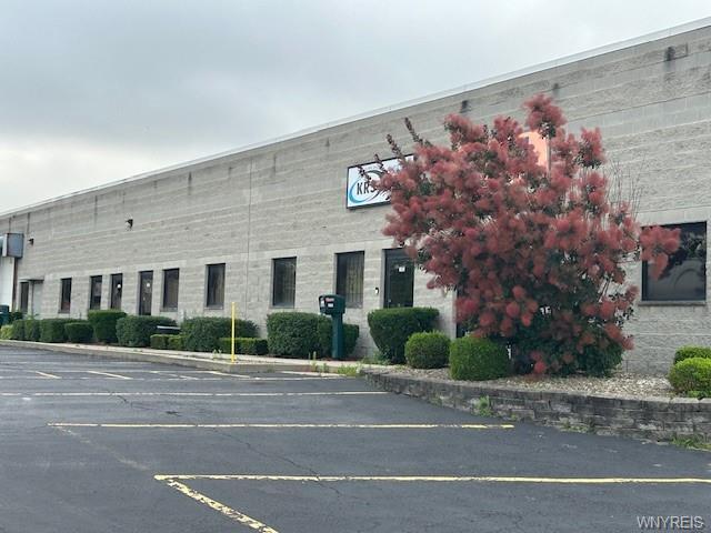
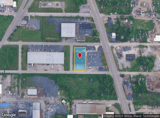
Property Record
1901 Maryland Ave, Niagara Falls, NY 14305
NEARBY LISTINGS FOR SALE OR LEASE
Property Detail
1901 Maryland Ave
291100-130-015-0001-005-112
TM 105 BL K PT 31 MR
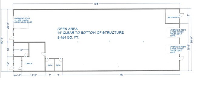
Warehouse
Niagara
X
New York
36029C0010J
5.112
2025
0.73 AC
2024
Niagara Falls
020200
Buffalo/Niagara Falls
16,875 SF
Buffalo-Cheektowaga-Niagara Falls, NY
DEMOGRAPHICS near 1901 Maryland Ave
1 Mile
3 Mile
5 Mile
2024 Total Population
6,893
40,201
66,322
2029 Population
6,912
40,132
66,054
Pop Growth 2024-2029
+ 0.28%
(0.17%)
(0.40%)
Average Age
36
40
42
2024 Total Households
2,714
17,130
29,064
HH Growth 2024-2029
+ 0.22%
(0.22%)
(0.41%)
Median Household Inc
$41,858
$40,099
$47,243
Avg Household Size
2.30
2.20
2.20
2024 Avg HH Vehicles
1.00
1.00
1.00
Median Home Value
$125,865
$89,371
$125,839
Median Year Built
1955
1948
1951
Nearby Places
Map Layers
Map Styles
 Street
 Aerial
- Restaurants
- Banks
- Shops
- Fitness
- Groceries
PUBLIC TRANSPORTATION
COMMUTER RAIL
DRIVE
WALK
Distance
4 min
1.9 mi
DRIVE
WALK
Distance
4 min
1.9 mi
AIRPORT
Niagara Falls International
DRIVE
WALK
Distance
Niagara Falls International
12 min
6.3 mi
Buffalo Niagara International
DRIVE
WALK
Distance
Buffalo Niagara International
39 min
26.3 mi
SALE & LEASE HISTORY
LISTING DATE
SALE/LEASE

Jun 20, 2024
For Lease
Nearby Properties
Address
Land Use
TOTAL SIZE
Lot Size
Zoning
Address
Land Use
TOTAL SIZE
Lot Size
Zoning
28,080 SF
2,888.10 AC
Address
Land Use
TOTAL SIZE
Lot Size
Zoning
137,958 SF
1 AC
Address
Land Use
TOTAL SIZE
Lot Size
Zoning
305,119 SF
11.80 AC
D1-D
Address
Land Use
TOTAL SIZE
Lot Size
Zoning
34.59 AC
I2
Address
Land Use
TOTAL SIZE
Lot Size
Zoning
23,280 SF
163.20 AC
Address
Land Use
TOTAL SIZE
Lot Size
Zoning
95,628 SF
5.10 AC
C2-A
Address
Land Use
TOTAL SIZE
Lot Size
Zoning
441,749 SF
20.54 AC
I2
Address
Land Use
TOTAL SIZE
Lot Size
Zoning
375,735 SF
6.90 AC
OS
Address
Land Use
TOTAL SIZE
Lot Size
Zoning
61.20 AC
02 - SINGL
Address
Land Use
TOTAL SIZE
Lot Size
Zoning
7.50 AC
05 - COMME
Address
Land Use
TOTAL SIZE
Lot Size
Zoning
18,829 SF
2.76 AC
OS
Address
Land Use
TOTAL SIZE
Lot Size
Zoning
64,006 SF
447.28 AC
OS
Address
Land Use
TOTAL SIZE
Lot Size
Zoning
167,976 SF
18.60 AC
Address
Land Use
TOTAL SIZE
Lot Size
Zoning
48.80 AC
Address
Land Use
TOTAL SIZE
Lot Size
Zoning
270,580 SF
2.10 AC
D1-A
Address
Land Use
TOTAL SIZE
Lot Size
Zoning
250,062 SF
2.60 AC
INS
Address
Land Use
TOTAL SIZE
Lot Size
Zoning
35.80 AC
Address
Land Use
TOTAL SIZE
Lot Size
Zoning
74,558 SF
1.90 AC
INS
Address
Land Use
TOTAL SIZE
Lot Size
Zoning
247.60 AC
Address
Land Use
TOTAL SIZE
Lot Size
Zoning
59,474 SF
10.14 AC
06 - INDUS
Address
Land Use
TOTAL SIZE
Lot Size
Zoning
3.30 AC
D1-D
Address
Land Use
TOTAL SIZE
Lot Size
Zoning
628,572 SF
4.22 AC
D1-B
Address
Land Use
TOTAL SIZE
Lot Size
Zoning
2,000 SF
4.90 AC
D2
Address
Land Use
TOTAL SIZE
Lot Size
Zoning
Address
Land Use
TOTAL SIZE
Lot Size
Zoning
106,800 SF
3.15 AC
D1-A
Address
Land Use
TOTAL SIZE
Lot Size
Zoning
296.91 AC
OS
Address
Land Use
TOTAL SIZE
Lot Size
Zoning
129,664 SF
5 AC
INS
Address
Land Use
TOTAL SIZE
Lot Size
Zoning
36,120 SF
83.58 AC
I1
Address
Land Use
TOTAL SIZE
Lot Size
Zoning
123,682 SF
3.30 AC
Address
Land Use
TOTAL SIZE
Lot Size
Zoning
336 SF
15.90 AC
D1-D
The World's #1 Commercial Real Estate Marketplace
Connect with us
© 2025 CoStar Group
The information above has been obtained from sources believed reliable. While we do not doubt its accuracy we have not verified it and make no guarantee, warranty or representation about it. It is your responsibility to independently confirm its accuracy and completeness. Any projections, opinions, assumptions, or estimates used are for example only and do not represent the current or future performance of the property. The value of this transaction to you depends on tax and other factors which should be evaluated by your tax, financial, and legal advisors. You and your advisors should conduct a careful, independent investigation of the property to determine to your satisfaction the suitability of the property for your needs.